ORH_wxman
-
Posts
90,902 -
Joined
-
Last visited
Content Type
Profiles
Blogs
Forums
American Weather
Media Demo
Store
Gallery
Everything posted by ORH_wxman
-
Doesn’t look like we’re getting a +PNA again any time soon but a bit of Rockies ridging would help. Looks like that happens the last several days of the month which may help those threats a little more after the 1/26 one. The 1/26 threat itself is still on the table but the upside seems somewhat limited due to a lack of ridging in the Rockies. Not that most people here would even turn down an advisory event if offered, lol.
-
January 16 2021 - Inland runner Rain/Snow/Wind
ORH_wxman replied to Baroclinic Zone's topic in New England
I’ve always wondered how much snow would be measured if someone was up in the Glastonbury wilderness NNW of Woodford in those 3000+ foot peaks. Like that would be an amazing spot for a ski resort. The terrain there looks insane for upslope. I feel like they’d easily get over 200” per year there but there is nobody there to measure it. Lol. -
I’d take Feb 63 and Feb 64...’60 was meh (though I’d gladly take it if it meant a we get a 3/3/60 repeat) and Feb ‘87 was an absolute nightmare.
-
Looks a lot like late January ‘69/early Feb ‘69. We got abused for like 3 weeks before the Lindsay Storm finally happened even though the pattern never really changed that much. I feel like one of those late month threats will pan out but maybe we just get tortured for another week or two.
-
Weeklies went wild with the -AO/NAO well into February. If that is correct, we’re either in for more torture or a lot of fun. Can’t punt with that look. (Well I guess you can but it’s like punting on 4th and 2 at your opponent 40 down by 7 with 4 min to go)
-
Yep. We get to keep rolling the dice...as long as you are rolling you have a chance. As I mentioned earlier, frustrating to keep missing recently but can’t fold the tent yet with that look.
-
Man, that looked like a carbon copy of 1/12/11 in the making. Almost identical shortwave setup. Would’ve been nice to see another panel or two just for the eye candy.
-
Future yellowjackets nest.
-
Niña is fast flow gradient with shortwaves getting sheared. Thats happening in the upcoming pattern but December and first half of this month had a lot of slow blocky flow...we actually had too many shortwaves at times starting to pile up on each other causing destructive interference which screwed us out of a couple events.
-
January 16 2021 - Inland runner Rain/Snow/Wind
ORH_wxman replied to Baroclinic Zone's topic in New England
Woodford def gets smoked but that report was pretty weenie-ish even in that context. I think Mitch (wxmanmitch who lives in Woodford) was a bit skeptical of it. -
Usually cold FL happens in El Niño though there are exceptions like 2010-2011. We talked about how much this past 6 weeks has looked like El Niño and not La Niña so the cold FL makes sense in that regard.
-
This is actually what keeps me somewhat skeptical of the resignation by many that February will be bad for snow lovers. Sure, I admit it might, but this SSW hasn’t manifested yet in the troposphere and it still could throw a wrench into February. Some of the longer term guidance shows the AO/NAO region starting to act a bit stubborn as we head deeper into February so maybe we we get something like a -WPO/+EPO/-PNA/-NAO/-AO pattern....those can be good (See February 1969) or they could still suck but I think we still have to wait and see what happens with that SSW impact.
-
There’s the longwave pattern and there’s the shortwaves embedded in it. We know what favorable longwave patterns look like. We have a good history of them. Longwave patterns are more predictable in advance. We have no idea what shortwaves will do until we get closer. There are examples of favorable longwave patterns that didn’t deliver (See January 1985). There are also examples of unfavorable longwave patterns that did. (See January 2006 for interior SNE) When meta discuss the “pattern”, they are almost always talking about the hemispheric long wave pattern. Usually we will specify when we’re talking scales smaller than that.
-
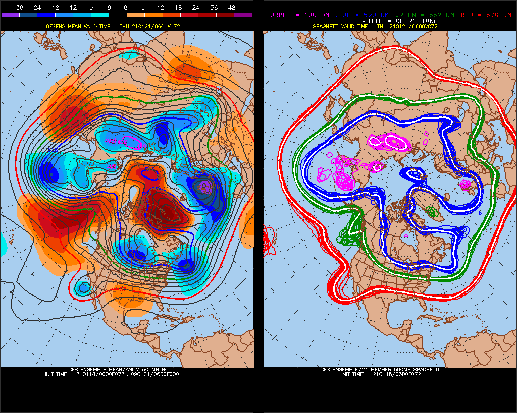
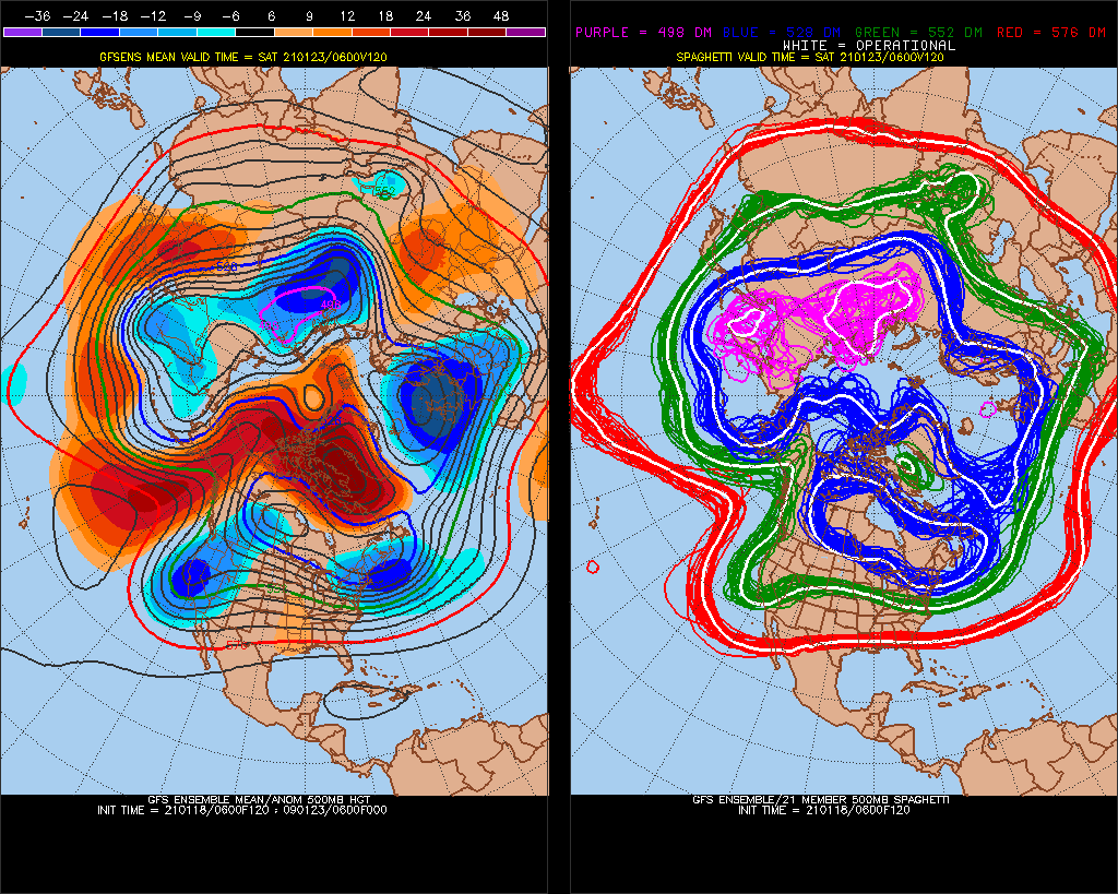
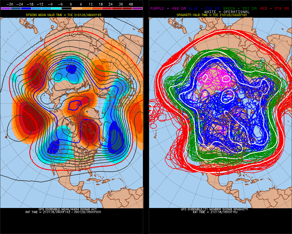
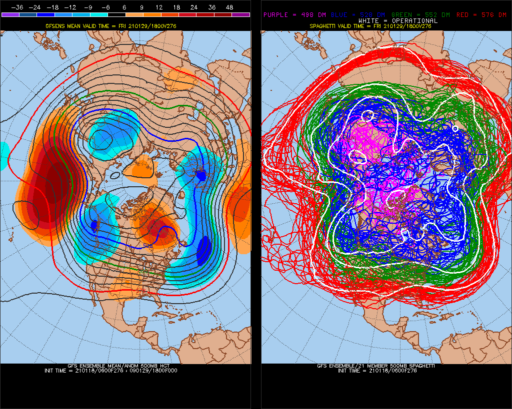
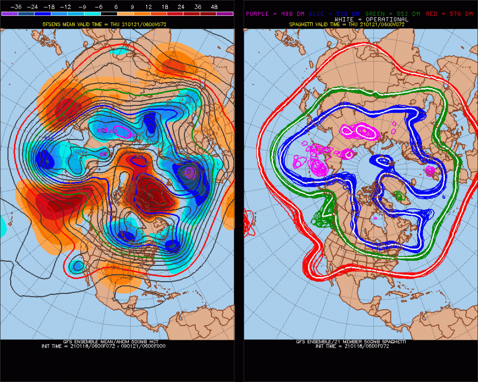
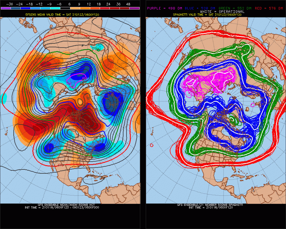
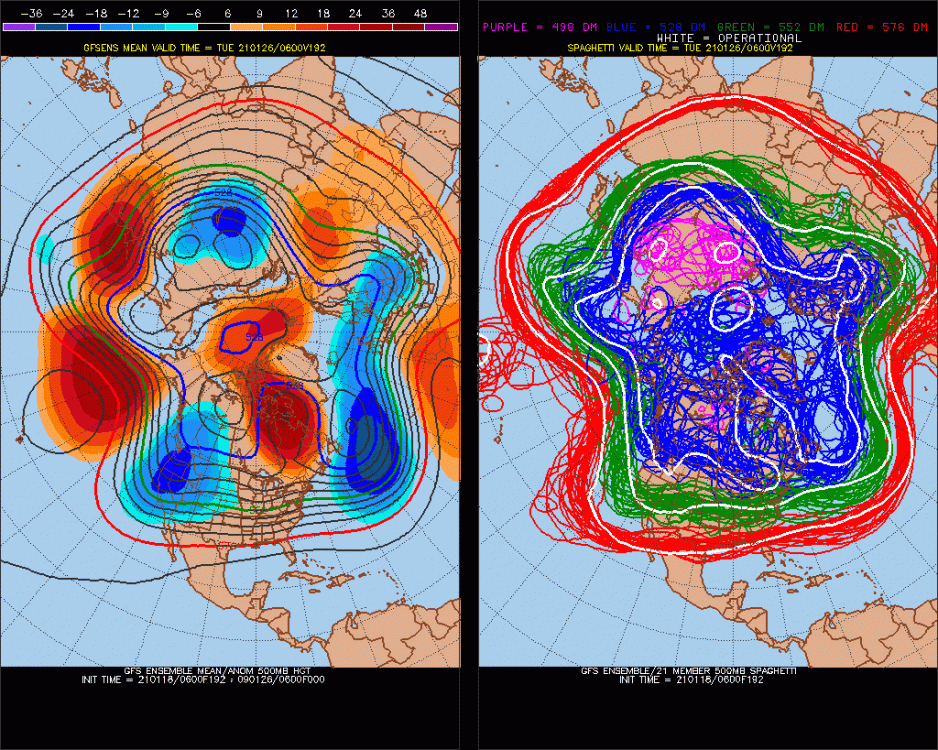
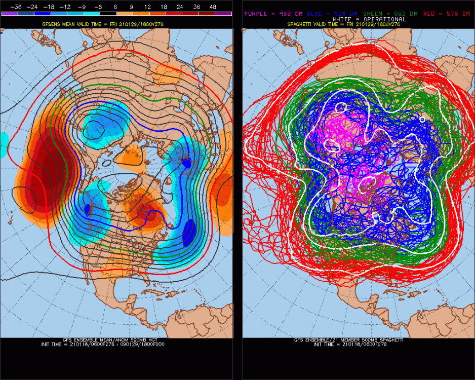
We’re in it this week. I mean, this isn’t a model phantom like last January. It’s going to occur. Here is the D3, D5, D8 and D11 N Hemisphere map H5 anomalies. You can see smaller scale problems on the closer maps inside of a week...smaller scale is obviously unpredictable at longer time ranges...but the -EPO/-NAO pattern is happening
-
Agreed that we’re not static, however I’d push back on assuming that CC means less snow here, at least in terms of where we are now on the timeline. The empirical evidence thus far actually points to the opposite conclusion. Eventually the warming would reach a point where it becomes more dominant than the “higher precipitation” signal which is driving the increased snowfall in the past couple decades.
-
One of the least snowiest Januarys on record....pattern wasn’t even that bad either kind of like this year. It wasn’t as torchy but slightly above average temps. Of course we all know that things turned around in Feb ‘69.
-
Without the -NAO we would have had an epic winter heat wave. Some of the objective analogs for the hemispheric pattern earlier this month were early January 2007....people might remember many spots hit 70F during that one. The only thing different this time was a west based NAO block that kept us in the 30s for the most part with well above average low temps. It was actually not a bad snow pattern, we just couldn’t get any of the shortwaves to cooperate....very narrowly missed a good one on 1/3-1/4 and then missed another chance on 1/12.
-
Nah, canceling would mean we suspend or ban or 5-post them.
-
I’m anointing Bob as the new Lenin....don’t worry, I’m his understudy Stalin lurking in the shadows waiting to take over.
-
It’s tough because the pattern looks good going forward...so as each threat fails, you get the urge to punt but if you are looking objectively at the pattern, you know you can’t because it is still favorable going into early February.
-
There hasn’t been a signature torch like you’d normally see with that type of departure over a half-month period. It’s been consistently pseudo-winter like with highs in the 30s but lows even more above normal. Very monotonous in the spread.
-
Amazing how much Jan ‘69 is showing up on the objective analogs these days...you hate to see it. Lets hope the season follows the same progression as that one did.
-
You are definitely being censored right now. I would agree genuinely as a person who really hates censorship. It’s also a weather forum so not a lot of sympathy from me. We used to never allow even financial talk in here...only started when covid happened. We always told people to go to off topic. We’ve historically been fine with marginally related wx stuff ala “what do people think of this type of snow blower, lawn mower, etc, etc”.
-
Yep. I’d ask this question first....how many times have you had 3 subpar seasons in a row? I’ll bet the answer is very few. For ORH I can only think of 4 times going back to 1950. (Btw I defined “subpar” as anything below the 40th percentile...so if ORH had 64” in a season, that is considered “normal” in my classification...even though technically it is slightly below the long term mean of 69”) 1. ‘97-98 through ‘99-‘00 2 ‘88-89 through ‘91-‘92 (this is 4 consecutive...the only time) 4. ‘78-‘79 through ‘80-‘81 3. ‘52-‘53 through ‘54-‘55 So our sample size here is actually 4. If you took it at face value, that means we’d have a 1 in 4 chance of getting 4 in a row. However, we know small sample sizes aren’t representative of the longer term probability, and the chances of getting 4 in a row are actually close to 50/50 unless there is some meteorological reason to believe that the 4th season is biased toward above normal snowfall after 3 subpar seasons. I certainly cannot come to that conclusion statistically with a mere sample size of 4 trials. We first need to reach 3 seasons in a row. That’s far from a done deal considering many spots are actually above normal still.
-
January 16 2021 - Inland runner Rain/Snow/Wind
ORH_wxman replied to Baroclinic Zone's topic in New England
Saw that. Looked like they were ground zero for yesterday/early today. Now the best upslope shifting north but even the southern/central greens should get some for the next few days. Great pattern there coming up too as next week will feature a lot of upslope while we whine about lack of synoptic snow everywhere else.