

ORH_wxman
-
Posts
90,902 -
Joined
-
Last visited
Content Type
Profiles
Blogs
Forums
American Weather
Media Demo
Store
Gallery
Everything posted by ORH_wxman
-
Starting this thread for obs on the snow showers today. Pretty good WINDEX parameters, but the one ingredient missing is a really sharp zone of lift. However, big LI spike and some PVA should help. Lapse rates are about as high as you will ever see them in winter with the column near saturation so if some squalls can develop, they will get quite heavy I think. TTs are near 60 this afternoon before falling. Best chance for heavy squalls will be mid afternoon for central/western areas and late afternoon for eastern areas.
-
RAP/HRRR are actually pretty nice looking later on for eastern areas....yes, I know some of you don't give a crap.....but for those who do, worth watching for some decent squalls. TTs near 60 are no joke. Obscene lapse rates.
-
South definitely favored. Still a lot of time though being 6+ days out.
-
06z EPS came pretty far north with 1/26.....should be noted that the 00z Ukie was wayyy north. Can't sell that one yet.
-
Our little 3 bedroom in Holliston built in 1966 has gone up like 100k+ in 4 years since we bought it. We bought it for 345k and most appraisals would put it at 450 now. It’s insane. All the new construction single family homes around here are going for 700+ and most of them over 800.
-
The snowpack around ORH after that storm was near 2 feet and high water content as there was a lot of sleet in a previous storm a few days before the 1/20/78 storm. If the Cleveland superbomb hasn’t knocked the pack down about a foot or more, the blizzard of ‘78 would have been even more disastrous for snow removal issues.
-
Tomorrow is the real WINDEX look but mostly south of you.
-
Someone's gonna grab at least that much I think....wouldn't surprise me if a few lucky peeps got 2-3".
-
Oh its the original Lundstedt paper. Just search his name and "wintertime instability index" and I'm sure you'll find it. But from what I remember, you want 1. T1 RH above 50% (preferably above 75%) 2. T1-T5 layer lapse rate of more than 10C (more than 14C was huge signal for squalls provided other parameters were good) 3. LI spike of more than 8 in a 12h period Some other "factors" to consider, but they tie into the above....big PVA (usually associated with the LI spike) and TTs over 50 (associated with very steep lase rates)
-
I remember that one...late March 2013. I think it may have been 3/21-22. Tomorrow isn't really a norlun per say...it's not stationary long enough, but it's more of a WINDEX look for a good chunk of the region south of the pike. It looks best closer to the south coast but can't rule out some decent squalls as far north as pike region. Your area may get something if lucky.
-
Total Totals in the low 60s tomorrow....that is really impressive. I definitely wouldn't be shocked to see someone get lucky down south with a couple inches. Max DGZ is around 800mb too, so that is going to help too. There's actually a lot of WINDEX parameters satisfied in this...big time TTs, huge LI spike, LL moisture, good PVA, etc.
-
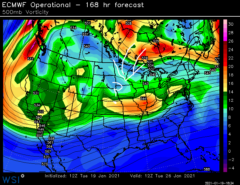
PV lobe is pretty far west this run on 1/26....lets get that involved and make it more interesting. Doesn't do it on this run, but that's not far off. Get it a bit southwest and that give us more upside in the 1/26 storm than there was previously. Also this is a D7 prog so take it FWIW....I know I shouldn't have to mention this, but we have some short-tempered whiners recently with the boring weather
-
Here's the high temps for ORH....the only day that remotel sniffed 50F was the 47F high in the warm sector briefly on Saturday thi past weekend. Otherwise......total snoozefest way to run a torch month.
-
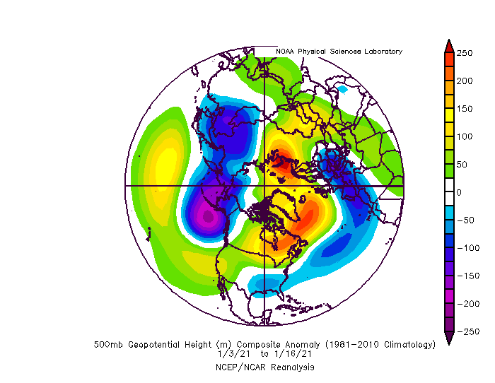
I feel the exact opposite actually....the temp gradient between NNE and SNE has been very low....hence the +9 to +10 anomalies up north and the +6 to +7 anomalies in ORH and BOS. We've lacked good baroclinicity most of the month. Thought he last 2 or 3 days that hasn't been the case as there was a frontal boundary that cooled off NNE while we were still torching a bit down here.
-
1956 was a pretty good Feb, esp north of pike....but not blockbuster. Obviously March was a blockbuster.
-
Yeah it’s still mind blowing to me too. There was easily over 100” in that same period just south or south-southwest of BOS.
-
January 16 2021 - Inland runner Rain/Snow/Wind
ORH_wxman replied to Baroclinic Zone's topic in New England
They must have gotten some kind of waiver. Check out “west ridge road” up on Stratton. The entire thing is above 2500 feet with some spots above 2600.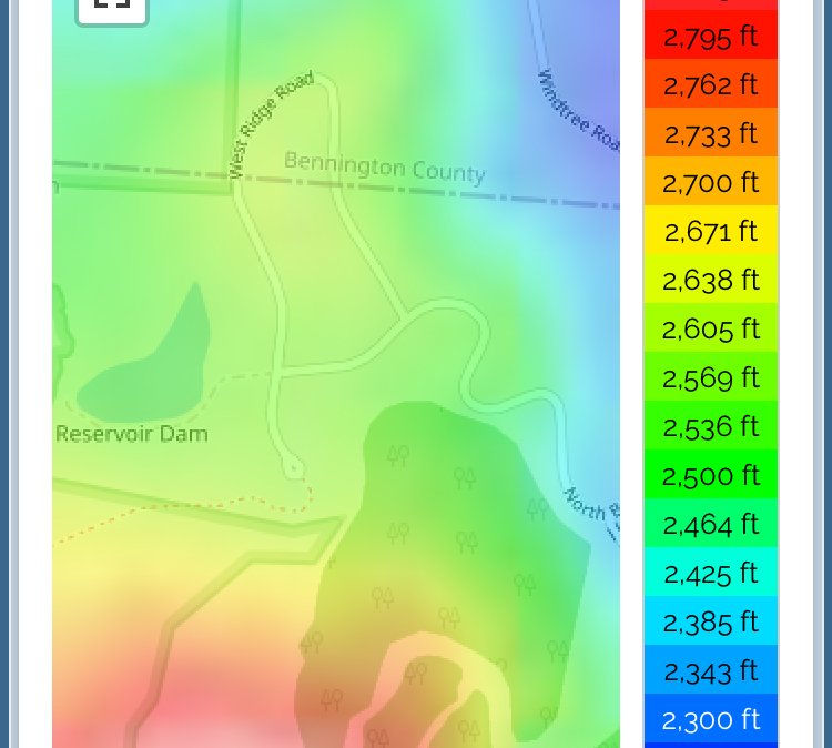
-
January 16 2021 - Inland runner Rain/Snow/Wind
ORH_wxman replied to Baroclinic Zone's topic in New England
Yeah I think we need to investigate the man-made snow contamination aspect of the W.E maps. I’ve been looking at several maps this evening from different dates and notice the peak itself really sticks out like a sore thumb....I know that any elevation is going to stick out but it seems pretty zonked. -
January 16 2021 - Inland runner Rain/Snow/Wind
ORH_wxman replied to Baroclinic Zone's topic in New England
They have them up around 2600 actually. I think they are more like million dollar houses, lol...but they are really high. I’ve looked before. -
Yeah it def favors storms staying south of us...of course the irony being when we needed it most (Friday night and early Saturday), we couldn’t get it to squeeze south of us and keep us snow. Usually you’ll get a storm or two that will try to run up into that block and produce for us...instead we just got skunked a few different ways.
-
January 16 2021 - Inland runner Rain/Snow/Wind
ORH_wxman replied to Baroclinic Zone's topic in New England
That’s interesting that Stratton might be similar or even better for W.E. I wonder if Stratton really rakes it in more in synoptic storms and then is only marginally worse in upslope? That would help explain the W.E. differences. One thing to keep a note in...Stratton has trails going around a good portion of the mountain so I wonder how much snow making contamination is in the NORHC maps? Something to consider too. -
You would’ve thought we could score at least 1 or 2 half-decent events out of this. I’ll consider us fortunate that the NAO isn’t going away any time soon and we’ll get to take some more hacks at it with a better cold source.
-
Ahh ok makes sense...yeah that’s how ridiculous that winter was, lol...we already had smashed 30 day snowfall records just over 2 weeks into the blitz and another major storm was on the way.
-
What’s the reference point on those dates? They definitely aren’t the “max snow in a 30 day period” that winter because BOS had 90.2” between 1/24 and 2/15 which is just over 3 weeks.


