

ORH_wxman
-
Posts
90,902 -
Joined
-
Last visited
Content Type
Profiles
Blogs
Forums
American Weather
Media Demo
Store
Gallery
Everything posted by ORH_wxman
-
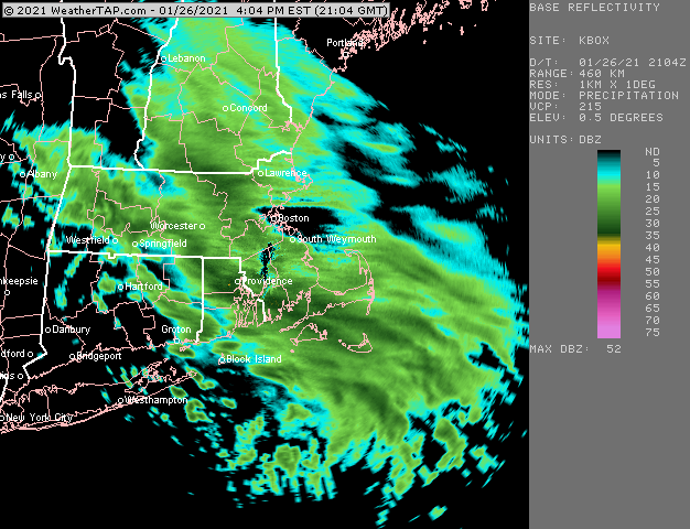
Getting some decent back building now in ORH county and just west along the pike toward CEF.
-
You can def see the snow shield kind of slow down in eastern MA/RI....hopefully that helps with some backbuilding later. ALmost all short term guidance shows it happening across CT this evening. Esp 5-7pm.
-
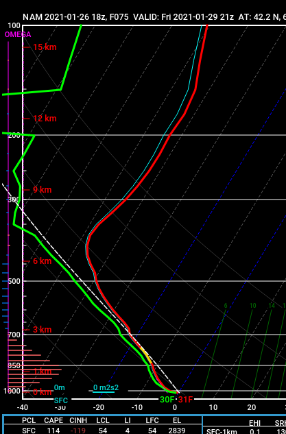
18z NAM sounding near PVC on Cape on Friday.....Dawn Awakening,
-
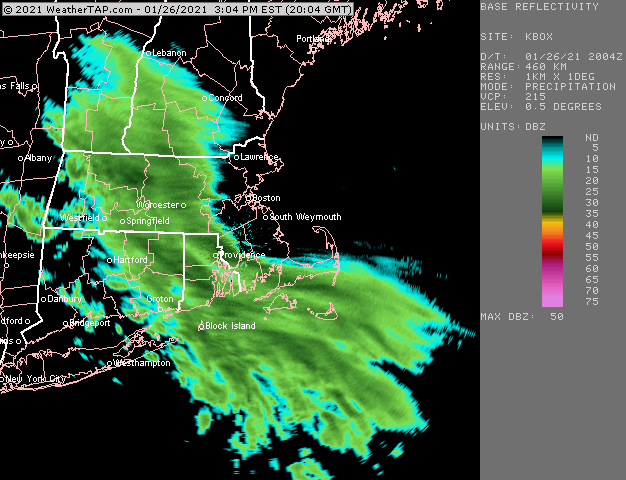
New 18z HRRR agrees with it filling in south and weakening north....but yeah, just looking at radar right now it looks like Ray's area would do better than my backyard.
-
Looks pretty nice actually on radar...hopefully we see some filling in where the front of the dryslot is
-
Nice job HFD KHFD 261853Z 17004KT 1/4SM +SN VV012 M02/M05 A2999 RMK AO2 SNB20 SLP155 P0001 T10221050
-
I dunno, that's a pretty crushing look for ORH to Ray's area on GFS...they basically stay on the NW side of the stalled bent back mid-level WF for like 18 straight hours. That's why it's like 1.5-2 inches of QPF in 24 hours. Doesn't matter at this range obviousl on details....but you'd want to hit that if you were there....all the way back to western CT.
-
2/19/93 redux?
-
It's giving you really good ratios on that map....you get like 4 tenths of QPF through 42 hours....but that map is spitting out 15 to 1 to give you 6" of snow.
-
I think we'll want that 2/1-2/2 event to really take its time moving out....that will help shove the next one south.
-
I think much of SNE will have a break tomorrow during the day...there may be some periodic flurries or spits of snow/snizzle, but we may have a 12-18 hour gap of very little before it tries to blossom again tomorrow night.
-
Deep snow pack seems to help more for things like coastal fronts. If you have an arctic airmass over deep pack, a CF usually has a much harder time penetrating inland....that low level molasses just provides more resistance with a deep pack. But yeah, it's not gonna help us if there is a deep H5 low ripping a low into BUF.
-
At least you are in the best possible spot save downeast ME if anything happens Thursday night....can't get much further east than Rockport. edit: Actually reminds me of an event in the mid/late 1990s...I can't remember if it was 1996 or 1997 since I didn't experience the event. But Rockport/Gloucester got clipped with an IVT/OES piece and got like 6-7" while 10 miles west had nada.
-
We need to make a Tshirt for you now that you have been at this for 25 years. We'll call it a 25th anniversary gift. "Ray's Kryptonite: Harping on ORH always being far enough in one direction since December 1996"
-
I'd watch it there too...you might be too far southwest, but it's close on some models.
-
Yeah it's like the lowest 2-3k feet of the atmosphere it's struggling with. But that can often be overplayed....esp near the coast. If the lowest levels are more like N aroudn Cape Ann, then that's where something could go nuts. Obviously digging that ULL further southwest will help the tug the sfc IVT further west too....so they are all connected.
-
You may be a little on the warm side for the first IVT tomorrow night with 34-35F slop....but you also might get a 32-33F paster. We'll have to see. The 2nd IVT Thursday night is in the arctic airmass and that is where there could be a surprise on Cape Ann. That could be a true Norlun type setup if it broke right.
-
The omega is actually half-decent back to like ORH.....that definitely has a little bit of bust potential. I wouldn't forecast accumulations right now for Thursday night, but that's kind of a red flag. Several parameters in place. Models don;t like to spit out QPF in the arctic airmasses like that and often screw it up.
-
Still gotta watch Thursday night too for extreme eastern zones...esp downeast ME to Cape Ann and maybe Cape Cod...but even NAM is trying to get a little finger of precip inland a little ways. That's a pretty unstable sounding so something to keep an eye on. 900mb winds almost turn N to NNE around there....so in addition to the LL convergence, there's a chance of an OES band or two to develop for time on Cape Ann and Cape Cod.
-
Tomorrow might not even precipitate for a chunk of the day....might be like 37F and overcast with spitting drizzle or a few cruddy flakes before it reignites tomorrow night under the IVT.
-
The IVT tomorrow night in E MA and SE NH is pretty impressive on the NAM and 3km....it's several tenths of QPF with the low level lift intersecting at about -8C to -10C. That could potentially be pretty nice with the salt nuclei.
-
Whoa....that ramped up. Borderline warning for the pike or just north. Meso short terms like it too (HRRR/RAP) but wasn't sure if they were just being their usual overzealous selves more than 6-8 hours out.
-
Avg highs of 40F aren't reached in SNE until late February (have to wait until 1 week into March for places like ORH)
-
Could be really intense too...but it looks like it might be too far east....downeast maine could actually be in a good spot. Acadia FTW....could clip the Cape too. But yeah, if that ULL trends a little SW, it could get pretty interesting.
-
Go ahead and start a thread tomorrow if we’re still looking good. You mentioned this system a few days ago in a lengthy post...so take it home. I doubt the threat is going anywhere as I agree with the reasons you have brought forth. It’s the strongest signal we’ve seen since the 12/17 storm which we tracked from 8-9 days out...this one has that type of look that produces the staying power on guidance.


