ORH_wxman
-
Posts
90,902 -
Joined
-
Last visited
Content Type
Profiles
Blogs
Forums
American Weather
Media Demo
Store
Gallery
Everything posted by ORH_wxman
-
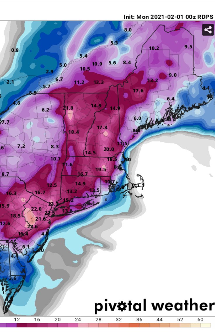
Yeah I’ve seen that on some guidance. But even if we rip from say 1pm to 11pm...that’s 10 hours in the firehose overlayed on the WCB dynamics. I’m not counting the light crap before 1pm which may add up to an inch or two. But yeah, there’s always “something” that makes it really hard to get 18”+ without being in the ML/CCB goodies.
-
That was a sick run on the firehose. I’ve been really really impressed with the look. The residence time is the only thing holding me back from going more than I am. But it’s actually a pretty long residence for that type of setup. We usually get WCB thumps and they rarely last more than 8 hours. This one looks to be a little longer than that in the meat of it and it’s got the fetch (firehose aspect) overlaying the typical WCB thermal/lift layout....so like Tip, part of me wants to just go ahead and chuck some 20-burgers in the east facing hills from 495 to ORH county... Of course, once I do that, then we get the almost-too-predictable 14.5” totals and I’ll smack myself saying “why did you ignore every other impressive looking WCB thump that gave you between 12-16” and decided to weenie out this time?” Though as has already been mentioned, we could weasel our way to higher totals anyway if we get several inches from Tuesday night/Wednesday ULL shenanigans.
-
I assume you mean 00z RGEM

-
00z rgem just gave me 2 feet. Lol Thanks to the storm going nuts again as it passes near CHH adding another 8-10”
-
What in the blue f*** is that model doing?
-
Yeah the 2” of qpf IMBY on the 18z run wasn’t happening...lol. Even the 1.5”+ on the 00z NAM is likely overdone, but we’ll see. The way the WCB sets up is pretty efficient for this area, so I feel 12-18 is a solid forecast.
-
Yeah I might extend the 12-18 closer to the coast though a few ticks but that is pretty good. I also don’t think the MA hole in the CT valley will be quite that bad.
-
LOL just saw Ryan’s map...it sounded like I was describing it giving Kevin my thoughts on CT. I hadn’t seen it previously. Glad they line up though. Something about great minds?
-
If I was still forecasting for union, I’d go 10-16” for you and prob most of CT except maybe like GON over to old Lyme and then it ramps back up near HVN on the south coast. I’ll go 12-18” for me/ORH area and 495 belt up toward Ray. Prob 8-12” for interior SE MA...including up into BOS though west side toward Jerry would add a few inches to that range. 6-10” of absolute slime for Scooter on the south shore. I admit that I’m not hugely confident in the CT forecast or the coastline of E MA. Seems to be more variance there on the models than a place like ORH or interior E MA. I could see things breaking heavier too for CT...there’s a chance western parts could get in on the ML goodies though it feels like to me the main benefit will be more out in the Catskills and NNJ/NE PA..but even if they get clipped or it keeps the WCB a little slower to depart, then maybe we see some 16-20+ numbers there . Im really hoping the 00z runs iron out some of the variance we’ve seen. At least one exciting thing about this system is there are several unknown factors going into it.
-
If that rejuvenation is real, then that would make me increase the numbers up there not cut them back.
-
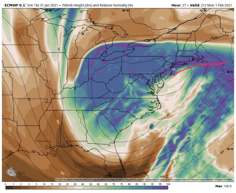
As long as you are north of the H7 warm front, you are usually going to be getting smoked. In this image it is easy to see as the height lines are bent back...that’s when we say “bent back warm front”....I marked the front in red
-
You’re prob getting better than 10 to 1 ratios back that way anyway. You’ll get more than 8-9”.
-
I’m expecting QPF to start toning down a bit as we get closer. They usually do in the final 18-24 hours. If we were actually going to get 1.5 to 2 inches of qpf, I’d be forecasting like 16-24 inches of snow here. I’ll acknowledge there’s a chance we end up going absolutely nuts for 10+ hours on the easterly firehose and still make or even exceed high end of the ranges, but more often than not, it’s hard to get those 20-burgers without midlevel goodies rotting over you. I’ll really be trying to parse the 00z data to see if there is any sign we are going to have the higher amounts.
-
18z euro looks a bit northeast through 24h
-
I think BOX’s 12-18 is a good forecast for here. 20-burger is hard to get unless you get stuck in ML banding which I don’t really see anywhere until out in Catskills down to NNJ. Only wrench is if the currier and ives stuff Tuesday night and Wednesday decides to add a few inches.
-
Whenever we have really good easterly flow in that 900-700 layer, you usually want to be bullish from about a Foxborough/Sharon back through 495/Hopkinton to ORH line. This is assuming your thermals are good which they should be west of 128. The QPF seems to go nuts on that type of setup...good orographics prob help on that direction...it hits 300-500 foot hills earlier then if it’s going from BVY to Harvard MA.
-
There will be some light stuff tonight in far southern and southwest areas. Doesn’t make much progress though until late overnight/early tomorrow. There could be some really light stuff that tries to sneak into western/central areas of SNE late this evening but the accumulating stuff is probably confined to the southwest coast until early tomorrow. Wouldn’t be surprised though if an inch or two fell though on the south coast before daybreak. Esp southwest.
-
My guess is a little further west between 128 and 495. Though I’ll admit I have pretty low certainty on this one. This is a pretty cold airmass sitting near ground level ahead of this storm.
-
Yeah that sounds right. Early on it may be more than that. Always kind of tough in these but sometimes that molasses arctic air will hold pretty tough and I could see something like 18-20F on the left side of it early on.
-
It’s there on the EPS. Obviously in muted fashion at 7 days out but there nonetheless.
-
Based on what? One storm on dec 17th, lol? We haven’t had any other biggies...Dec 2019 he was actually one of the BETTER totals in SNE.
-
You’re gonna have a lot of failures in the chase aiming for the jackpot all time. You’ll feel like Wily Mo Pena a lot...tons of Ks but then you get the high of him hitting one 490 feet when you finally hit the jack.
-
Maybe on Friday. Euro actually comes close to keeping that frozen here (it does for NNE)...might actually give an inch or two before it flips to RA- and then FROPA.
-
Our Davis Strait friend is back and saves our bacon on that run. That thing prob rips through SYR otherwise
-
It definitely could do that. Model guidance has the firehose the strongest down in the southern half of SNE and it slowly weakens as it moves north. The way you could get lucky though is the CF. This is gonna have a tight CF I think and you might spend a decent amount of time barely on the cold side of it which enhances the snowfall. So that’s what I’d be rooting for there (obviously in addition to hoping the firehose doesn’t weaken much up there).