ORH_wxman
-
Posts
90,892 -
Joined
-
Last visited
Content Type
Profiles
Blogs
Forums
American Weather
Media Demo
Store
Gallery
Everything posted by ORH_wxman
-
Euro was still pretty warm. But other guidance has definitely cooled a good bit in the last 24-36 hours.
-
Yeah that was a legit epic storm for NNE. I’d prob reserve the weenie terms like BECS as storms that are just utterly crushing for a really large area. 1888 comes to mind. Maybe 1978 as well. Feb 2013 was honestly not too far off but I think the forecast was pretty good on that storm and it mostly occurred on a Friday night/early Saturday so the societal impact was not quite as large as some of those others.
-
I haven’t had one in ORH either. Highest I’ve seen was Dec 1992 in Holden MA where we had 35”. There were legit 36-40” amounts in a narrow band in CT surrounded by a somewhat wider area of 30-36” in Feb 2013. But it’s a mesoscale band kind of similar to what happened in Dec 2020 when some narrow spots saw 36-42”. I think Xmas 2002 west of Albany had a narrow band of 36-42” also.
-
Yeah still out in clown range but it’s been semi-consistent on ensembles the last 2 days. I’d def classify 1/6-7 at the first widespread “chance”…hopefully it actually becomes a legit threat once we get into the middle of next week.
-
DT had 3 terms: SECS MECS HECS They were in that order too. Weenies added other ones over the years and they may have changed rankings but the original 3 were above and they went in that order. This is like circa 2000-2001
-
December 2024 - Best look to an early December pattern in many a year!
ORH_wxman replied to FXWX's topic in New England
I just looped the entire month of Dec 1989 on reanalysis and it's amazing. The first time the 850 0C line makes it north of MA is 12/31/89 the entire month. Most of the month is spent double digit negatives at 850mb. -
I think we'd want for 12/30 to phase more and be a deeper system as it cuts inalnd and that would push the boundary further south for 1/1. I think SNE is pretty cooked on 1/1, but NNE has a shot maybe. I suppose if it trended hard enough, we couldn't rule out rain changing to snow over the interior in SNE, but it's a long shot.
-
Honestly prob since Jan 2022 is the last time we saw something like that....and if you want to get specific on the more frigid look, it's prob been since 1/4/18 since we saw that look. Obviously those were both KU storms, and it's irresponsible to say we'll repeat, but that's the type of longwave flow you want to see for that type of higher end potential. But all of us would even take a run-of-the-mill 6-12" coastal right now. Hopefully we see some specific threats become more coherent on guidance as we get closer. It would suck if we can't time anything and end up cold/dry.
-
EPS seems to focus on Jan 1-2 (warm storm except maybe NNE) and then wait until 1/6 for the next event. GFS suite tries to maybe amplify 1/3 a bit on the heels of the Jan 1 storm. EPS still looks pretty active in that 1/6-1/10 period.
-
Yeah there’s definitely a difference between getting like 20-27” and 30”+. It’s really hard to break 30. There’s a reason you see so few of those numbers at first order sites.
-
30” storms are exceptionally rare for a single spot but there’s some climo favored areas and then climo disfavored areas. East slope of the northern Berkshires is prob the most climo-favored area in SNE. Next would prob be N ORH county. Both regions can do really well on deep layer easterly flow events. Next is prob interior SE MA. The one thing those 3 areas have in common is they can often be big QPF maximums in coastal storms. The first two are due to orographics and SE MA can wring out a bit extra due to the frictional low-level convergence of sticking out into the ocean. You’re not far displaced from the moisture source as a bonus. But I think the 2010s prob set the bar unrealistically high on the expectations of frequency on these storms. It’s still very hard to get…even in the climo favored areas.
-
It was really two events back to back but somehow got classified as one. I had nearly a foot of paste in ORH in the first one on Feb 23-24 and then almost all rain in the Feb 25-26 system. Berkshires got slammed with 2+ feet in the first one but had some ptype issues in the second but managed to grab a foot of sludge before grabbing additional snow after the storm occluded. Where it stayed all snow just west of Berkshires in the Helderbergs and Catskills they got 4 feet plus out of the two systems.
-
Ray might start posting blog updates while in the hospital right after new years. First a kind of classic SWFE on 18z gfs and then a longitude coastal (favoring eastern areas) after that.
-
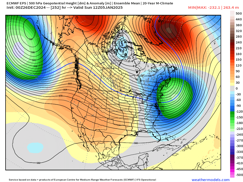
Pattern Verification matters too. We had some excellent looks fail to materialize over the past couple years. So the great pattern never came. We did get a pretty favorable pattern (but not as good as what’s progged right now) in December 2022 for about 10-12 day period but we mostly struck out in SNE save for a light event on 12/11/22 I think it was…that was the infamous phase of the PV out west which turned a D6 snowstorm into the Buffalo blizzard. Last year we had many head fakes…WPO/EPO region always seemed to deteriorate as we got closer. That isn’t the case this time I don’t think. It’s been pretty consistent and we’ve already verified some favorable pacific look this cold season.
-
December 2024 - Best look to an early December pattern in many a year!
ORH_wxman replied to FXWX's topic in New England
Ludlow is a really good spot. The old coop (now defunct) used to average almost 100” per year iirc. Can vary a bit depending on elevation there but generally that’s a solid spot in the middle of the greens. Most of the town is above 1,000 feet already. -
I looped the EPS individual storm tracks from 06z on the 6th onwards until the 10th and you can def see how the chances look to become more numerous as time goes on that pattern…it’s obviously a bit buckshot and diffuse being so far out but there’s definitely a pattern of more chances deeper into the run

-
That’s a decent way to look at it. When the pattern is not favorable, then we have to thread the needle to get a system. A good pattern gives us wiggle room on the track of a shortwave and as a cherry on top, favorable patterns are often stormier too, so in addition to not needing a perfect track, you also have more chances in general. (This isn’t the case every time. Sometimes we get too dry and suppressed)
-
Nobody likes waiting…esp when we haven’t had a major (double digits) event yet this year and some peeps here haven’t had one since 2022. So I can understand the impatience. But in this case, I don’t feel anything has been can-kicked. It’s always been the first week of January for a while. Originally weeks ago we were hoping for late December after Xmas looked like shit but then our cold period got extended into Xmas and the shit period decided to happen the week after Xmas before the big reload. But for at least the past week or so, it’s looked like first week of January to flip.
-
Yeah first legit shot for SNE is prob after 1/3-ish. Timeline has been pretty similar for almost a week now: 1. Pure crap for everyone until New Years 2. NNE might sneak something from Jan 1-2, but iffy even for them. 3. Maybe something smaller in Jan 3-4 time range (scraper or clipper) 4. Larger potential beyond Jan 5th
-
Pattern does get a lot more active after the 3rd/4th it seems. I think most people have a hard time conceptually understanding good pattern/bad pattern discourse from a probabilistic standpoint. A good pattern doesn’t guarantee anything but it loads the dice in our favor. A bad pattern doesn’t exclude snowfall either but it loads the dice against us. But I’d say about 75% of the forum posters don’t care for probabilistic discourse. They want guarantees. If the storms aren’t showing up in the short/medium term guidance inside of 5-6 days, then its going to be negative talk from them regardless of what the longer range shows…if the LR looks excellent, they will roll their eyes and say wake me up when it’s closer. If it looks like crap, they will assume it’s correct and bitch about that…I always found that part funny.
-
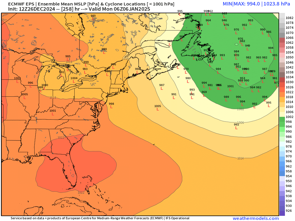
EPS:
-
I’d say the two dates to watch in the next couple weeks for snow potential are 1/3 and 1/8. The earlier system around new years looks too warm…maybe NNE can grab something from that. 1/3 isn’t supported by euro suite but GFS has been trying to amplify a wave behind the NY system. 1/8 is a more supported longwave look. But obviously too far out to really have a strong signal yet but there’s been a weak one for a couple days.
-
Be sure to tell RIC weenies that they can lock in their entire seasonal snowfall climo in one storm these next couple weeks.
-
Think we had about 15-17” or so in 1995 in ORH. But we had some extra snow OTG from 12/9 which made it a glacier base whereas closer to the coast didn’t do as well in that one.
-
The “falling on Christmas” was always made up at least as far back from when I was a kid. All the Mets used to say a white Xmas meant 1” or more OTG at 12z Xmas morning. Maybe there was some other definition back during the days of snow up to thy knickers. Merry Christmas and Happy Hanukkuh weenies.