

ORH_wxman
-
Posts
90,902 -
Joined
-
Last visited
Content Type
Profiles
Blogs
Forums
American Weather
Media Demo
Store
Gallery
Everything posted by ORH_wxman
-
That one would give PTSD to anyone in SNE who remembers it....I think it gave LI a foot and even croaked ACK but basically whiffed everyone else (maybe like 1-3" for far southern areas)
-
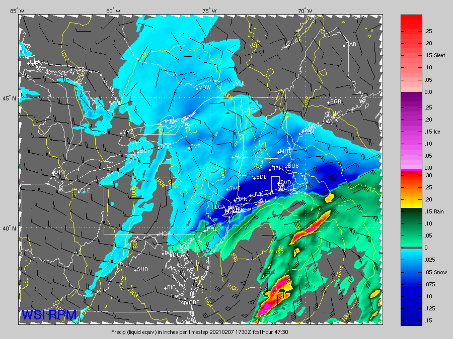
RPM and 3km NAM agree...that's an unbeatable combo
-
LOL at 3km NAM....that is ridiuclous. Like trying to pull a 12/9/05 or something with a 6 hour nuclear detonation
-
Northern stream is fighting it a bit on the 18z NAM but southern stream is going wild, so it might overcome it.
-
-
Euro was kind of the last hold out on a major system for 2/9 last night but finally went flatter at 12z today. Given the fast flow and multiple vortmaxima, we definitely cannot rule out a quick change back to more amplified on future guidance, but just looking at the pattern, it seems like the one behind it is probably more favorable for a larger QPF dump as the PV retrogrades west a bit.
-
That thing is getting more and more sheared out every run....I am starting to agree with Tip that we punt that one in favor of 2/12-2/13. We might still get something light out of 2/9, but I am doubting a major QPF producer from that one.
-
Prob pretty good up into TAN too.
-
This run is going to be good at least for SE areas...might get central SNE good too.
-
Yes it is. You can already see it at 30 hours.
-
Yeah I'd never want to make changes just based on the GFS/NAM/Canadian suites....I'd want to see Ukie and of course most importantly the Euro before making a big change that will potentially affect many people's plans.
-
They'll bump them up if the Euro jumps on board with bigger amounts.
-
Look at the wind flags on that map...you'll see they are SE at 50-60 knots over LI sound but by the time you get into NW CT, they are southwest at 40 knots. There will be a pretty good cutoff in the heavier stuff with that type of look.
-
Yeah in this event you sort of want to be right on the nose of that 700mb low that is pointing toward S RI there....maybe just a hair north of it. There's where you're gonna find some intense banding.
-
One things also in the 2/7/03 event was that the QPF wasn't a huge bust, I think BOS had under a half inch of QPF and even blue hill wasn't much more than that. It was that there was an absolute perfect cross-hair sig in that with a deep SGZ so it was basically 20 or 25 to 1 blower powder.
-
I think BOX had upgraded to advisory late in the game in the overnight package for the pike region. I remember the advisory being out (the old snow advisory), but nobody saw the obscene mesoband coming. Obviously back in those days, the model guidance was a little harder to parse for that kind of thing.
-
Yes there are a few similarities to that one....but it's not as robust of a shortwave and the orientations will be more NE to SW rather than the bands tilting more vertical in that 2/9/17 event. Both occurred in a very fast flow environment and assuming the modeling is correct on this one, both have excellent ML fronto features.
-
ORH is prob better than CON by a couple ticks, but I think where dendrite is does better than ORH by a few ticks and his area up there is also better for retention. That is that start of big time CAD land. ORH is a good spot for retention overall but not as good as getting up north of CON. ORH is sort of where the CAD starts in earnest in a lot of messier events, but it hits a new tier when you get north of CON and then it goes into nuclear bunker mode once into W ME. If you like monster 18"+ synoptic storms, then ORH is one of the best spots due to the elevation and proximity to the ocean. There is really no terrain that screws with it during ocean storms....easterly flow or northerly or northeasterly flow are all going to work there.
-
The flow is really fast and there is a stout NAO block up in Davis Strait/Baffin island area....there's not much room to come west. I'm considering it fortunate if it is far enough NW to hit SNE.
-
Always possible. Though this isn't really a "stealing the snow" setup for ORH, it is more likely the type of setup that ORH will be just far enough southeast to get into the really good stuff and then Ray will complain how they are always "just far enough in one direction" to get the goods.
-
Nice move on the GFS. Big fronto-sig over SE MA/RI that run. Someone is going to get a good band in this.
-
Reggie is a pretty big hit. Widespread warning amounts for SNE except far NW MA.
-
Have a solid coating new but the band is already moving out. That'll probabyl do it...mostly disorganized stuff behind it and BL warming too throughout midday.
-
Actually ripping pretty good here now too. Band looks thin though, so prob won't last long.
-
It's basically a 6-8 hour storm. We're not counting a few stray flurries that might pass by at 10pm hours after the real snow stops.


