ORH_wxman
-
Posts
90,902 -
Joined
-
Last visited
Content Type
Profiles
Blogs
Forums
American Weather
Media Demo
Store
Gallery
Everything posted by ORH_wxman
-
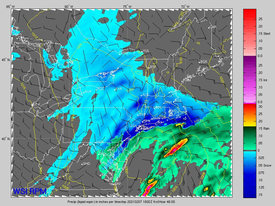
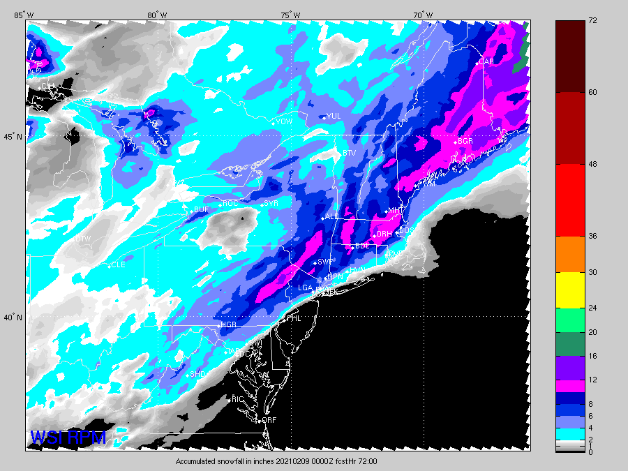
I’m not down...I think we all at least see an advisory event which is nice on top of a big pack in the interior. I’m just a little leery on the warning snowfall amounts outside of SE MA and RI because these things can easily tickle a little further southeast. We’re all of the sudden spoiled as we have two more events inside of 7 days after this one. But not every event is going to turn into 10” of snow and this one could end up as one of those that slips a little SE. We’ll see though. I think 12z will be telling.
-
Tuesday seems to have stabilized in model guidance. I was worried it would just getting weaker and weaker from sheared fast flow but most guidance seems to agree on an advisory type event for SNE and that probably extends into CNE/NNE as well. Then the end of the week has legs for something bigger.
-
I feel like there are more arguments for a SE tick...really fast flow, no phase, big NAO block, etc. That’s definitely the worry. That said, hopefully this southern stream vort beefs up a little in the final 24h and that could overcome some of those other issues.
-
Most of us can’t really afford another tickle SE so the 12z runs are pretty big.
-
Looks like this: 00z: All models SE except Euro which tickled NW 06z: GFS/NAM SE again, but ICON/RGEM bump back NW Hopefully we get another bump NW on the 06z euro.
-
Prob too soon. Usually it’s inside 24 that happens. But who knows. These aren’t large moves. But obviously being on the edge of the goods makes small moves seem much larger.
-
GFS is looking more subdued through 30 hours.
-
Yeah that gets a massive part of the entire forum...though I think our far SE posters would start lobbing grenades at us if that verified.
-
Yeah it was slightly SE of 18z but still a huge hit for a large chunk of posters. Minor differences.
-
-
RPM zonked up again. RGEM looks slightly SE of 18z.
-
Yeah 3k was actually less impressive than 18z which says more about 18z than the 00z run. The 00z run was still ridiculous but didn’t quite match 18z. Regardless. Someone is gonna get croaked in some banding with this.
-
Still a huge hit for many. Just not quite as crazy as 18z
-
NAM is gonna be SE of 18z
-
Yeah I think it would actually hit eastern areas harder than the qpf showed. H5 looked a little better.
-
I honestly thought that big CCB at 48h was gonna destroy E MA but then it slid just east. It got lighter stuff a little further inland. But this was kind of a wash with 12z.
-
End result is pretty close to 12z. Maybe just a tick better in getting precip further inland. Incremental changes.
-
18z euro looks a smidge more amped through 36.
-
Yeah you’d basically have to double that for 90th percentile imho. Maybe not quite double it further east but close.
-
1/27/11...different type of system though. That was the one where Ginxy to Kevin was getting 4” per hour for a couple hours straight and Kevin slept through it.
-
Also make sure we specify that it could have been pre-local on the 8s. I think that was sometime in 1996 they implemented that schedule. Prior to that, the local forecast was sometimes played within 5 minutes of the previous one.
-
That was a nice little move on the GFS. That’s probably double digits for SE MA that run but it extends some pretty good snows well inland.
-
This feels like the classic tickle back SE storm in the final 12-18 hours. Tonight and tomorrow there will be some more zonked runs that start spooking the southeast crew and then it will settle back to reality a little bit in the final run or two.
-
Yeah it might have actually been better up your way..it doesn't turn east quick as quick as the NAM

-
This is prob the best frame for Philly