ORH_wxman
-
Posts
90,902 -
Joined
-
Last visited
Content Type
Profiles
Blogs
Forums
American Weather
Media Demo
Store
Gallery
Everything posted by ORH_wxman
-
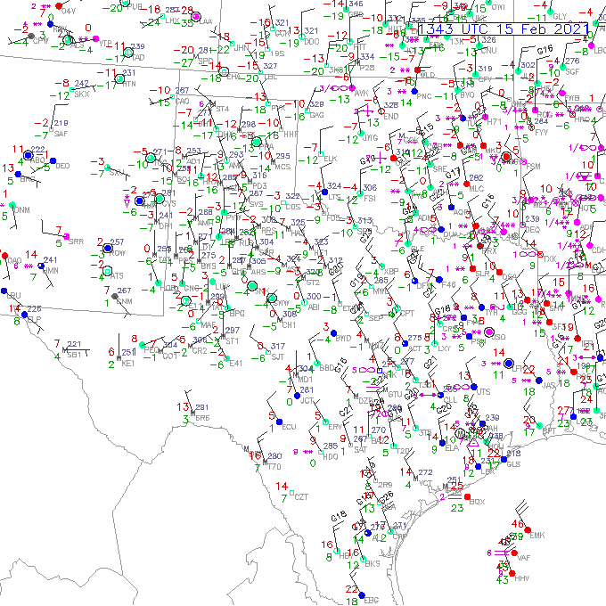
Even in the 12/2008 event in ORH, I had trouble accreting during the day on 12/11/08...we were icing up on trees and stuff but my car windshield and even the grass was kind of meh until dark. Obviously that was marginal temps, but even near the winter solstice, the time of day made a difference.
-
Interesting...the ZR is now starting to glaze the deck whereas a couple hours ago it was just wet. We’ve dropped a degree or so since then and also lost peak insulation. That was enough to make the difference.
-
We’ve dropped a degree in the past hour or so. Down below 29F now. Freezing drizzle for the past 30-45 min.
-
2/22 still showing up on euro/eps. Get that one to dig just a little more and it would prob be a nice miller B Tip-NJ model storm.
-
Noticed some new small icicles hanging off the step ladder outside from the recent round of ZR. Funny, because the part of the deck that had been cleared was just wet. Temp is hovering just below 30F but peak insolation combined with the slightly darker color of the stained wood didn’t allow freezing there but the silver metal step ladder was iced over.
-
Definitely a much colder look on Euro than yesterday. Maybe we can grab a nice little fronto band for a time.
-
They are assuming this one will trend the same way as 2/16 did. Not sure the meteorological reasoning, but that’s been posted a few times already.
-
2nd best scoring model.
-
Had a mix of sleet and ZR earlier. I think this current batch is straight ZR though it’s pretty marginal given time of day and temp. Temp is 30F.
-
We’re actually getting some pellets here mixed with ZR with this little batch of precip moving through.
-
The grinch storm had no CAD at all. It was literally southerly flow at the surface hundreds of miles into Quebec. It was ridiculous. Like maybe Jan ‘96 rivals or exceeds it in my own memory...not much else. 1/31/13 was pretty impressive too but prob not quite on par....12/17/00 as well. This is a dime a dozen CAD event we see in winter with a “cutter”. Primary dies in NY state.l with strong CAD sig over most of interior New England where the warmest temps occur when the cold front passes and briefly mixes out the warm layer.
-
Yeah it’s not that far from trying to be all snow synoptically. My guess is we still taint, but if we get a big thump first, I’m fine with some pellets/FZDZ to finish in the slot. I just don’t want one of these 2-4” deals followed by prolonged heavy IP/ZR and 35F rain before ending. Those are an abomination to clean up.
-
This shows you the true level of psychological damage the 2020 grinch storm caused. Now even a CAD storm is going to wipe out a deep pack...somehow in a window of like 6-8 hours.
-
V16 went colder/E as well.
-
You can toss 50s inland. SE CT to SE MA might get them but not 495 to 84.
-
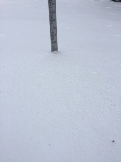
Current undisturbed pack depth...we’ll see how much is lost in 30 hours.
-
EPS looked nice too. Def showing a lot of redevelopment...it’s a good look for a heavy front end thump when you have that arctic high just north of CAR
-
What in the blue fook are you talking about? There is major CAD with this system even if it rains. You aren’t wiping out a double digit high-water content snowpack in central MA with ZR and then 34F rain. Even if it spiked to 45F for a few hours on FROPA that is basically meaningless. You’d have enough trouble wiping out that pack with a 12/25/20 redux.
-
It’s possible you go to rain for sure. But it would likely not happen until a lot of ZR first. Still a little skeptical of plain rain where you are though unless we’re talking some 33F drizzle in the dryslot. We’ll see if any trends stabilize or reverse by tomorrow.
-
I’d be surprised if we got any measurable snow at all before the ice (and then rain)...maybe a brief period of light snow tomorrow but even tomorrow looks more sleety if anything happens later in the day.
-
Absolutely. Not subtle...I’m already expecting a good chunk of liquid given these trends. But I’d rather get a few hours of raining at 37-39F in there to clear the ice dams at this point than have it be mostly 33F rain which is going to be largely useless.
-
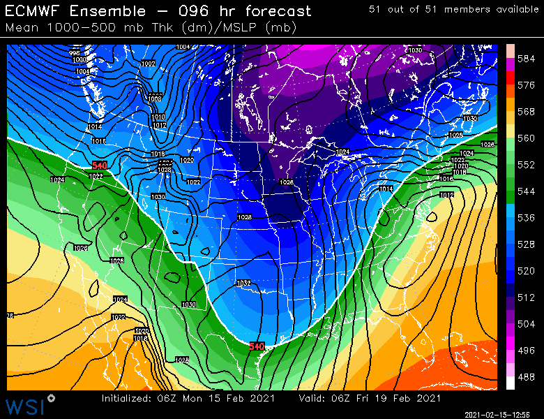
The difference is that arctic airmass advects in. If you remember, that same airmass was supposed to advect in ahead of this storm back when it was an SNE snowstorm. Here’s Euro H5 from a few days ago....check out that northern stream way ahead of the southern shortwave Now that airmass advects in behind Tuesday’s storm. We’re not getting the brunt of it, but it should produce an antecedent airmass colder than the one for this storm.
-
At this point I almost want it to be more like 37-39F rain to try and melt off some of this ice damming on my roof. A few hours of ZR and then 34F rain will be mostly useless. The pack here is already decent water content, it’s going to be able to withstand a grenade launcher after this debacle. Better be worth it for Thursday...lol.
-
Not this time. Coming in furnace.