

ORH_wxman
-
Posts
90,902 -
Joined
-
Last visited
Content Type
Profiles
Blogs
Forums
American Weather
Media Demo
Store
Gallery
Everything posted by ORH_wxman
-
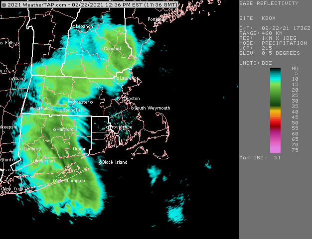
Mostly RA- here....some hideous flakes mixing in at times. Down to 36F....not sure we're going to flip to straight snow. Maybe int he next hour or so if we can get some better lift.
-
RA/SN mix right now at 37F....went outside and it's barely precipitating.
-
Started off as flakes here
-
38F here too....but it's going to try and wetbulb.
-
About to commence here....we'll see what ptype it is
-
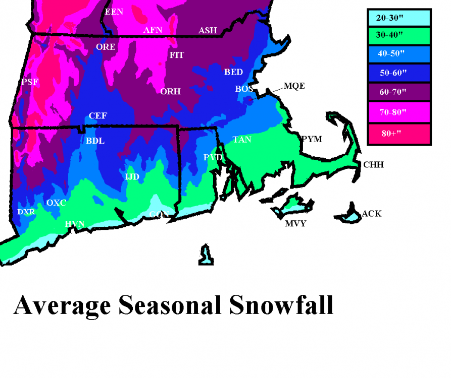
Long term BTV is like 74" or something...but I think more recently it is much higher. I remember noticing that their avg since 1970 is closer to 84". Some of that may be measuring techniques which would affect them up there more than a place down here. They get a lot of fluffier clipper/LES/blocked upslope type events where if you don't measure right away, you may underestimate it quite a bit. On the flip side, compaction is really only a huge deal on large snowfalls. But if they used to be a once per day type measuring spot prior to the mid-20th century, even the little ones may add up after a while.
-
I have such a good snow pack here that I'm hoping to grab an inch or two of slop to make it look even more impressive, but even if it's rain, it's prob not melting much of anything in the mid 30s....it will just put more water in the pack as the powder on top absorbs it. It's too bad we couldn't keep that high holding a little tougher to the northeast, because that would have made this a really good injection low type event....prob widespread high end advisory to low end warning if that happened because not only would we all be a little colder, a high holding tougher would increase fronto and wring out extra moisture on this sucker.
-
Up to 37.5F here now...just torching. I was 27F not even 2 hours ago. Obviously things could wetbulb back down as dewpoints are still in the 20s, but I have a feeling even if it does, it would be a lot of white rain type snow.
-
The ORH to MQE corridor has been another local jackpot area in SNE....that band like 10 miles either side of that zone. Though today prob won't do much east of ORH, but we'll see.
-
I haven't looked that closely since it didn't look that great here. SW CT looks like a decent spot since the sfc trough will try and focus the LL moisture there.
-
1-3 for you....3 if lucky and you really crank for 3 hours or so. Litchfield county may get some 4+ lollis
-
Up to 34F here....was 27F like an hour ago.
-
You'll get a few inches...nothing big. But there's enough push north to get at least 2-3 well into NNE.
-
Latest HRRR actually gets snow pretty close to Boston late this afternoon.
-
There's prob 2 chances to try and time something perfect in early March....first attempt is around 3/1 and then maybe another a couple days later. The pattern has been swinging a lot on each run though with multiple shortwaves, so these could change and I expect a lot of volatile model runs until we get closer.
-
Had some weenie flakes here about 15 min ago. Not sure what to expect here....not much accumulation is my thinking but we may get some aggregates at 34F later....might be just far enough west though for an inch or two. I'd bet winter hill in ORH grabs a couple though.
-
-
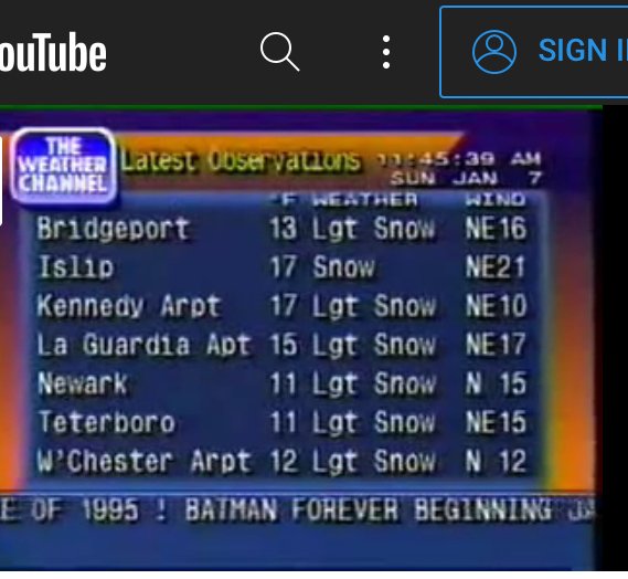
That’s awesome. Little nitpick but didn’t wxStar 4000 not have all caps on the latest observations station list?
-
All about the rates in this one. Gonna need 3 hours of ripping S+ or near S+ to grab 2-3”.
-
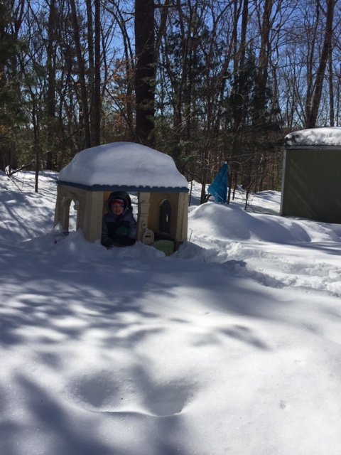
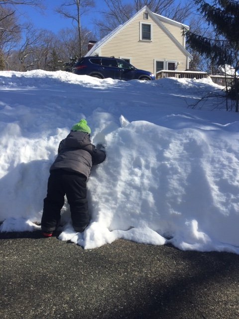
Perfect snow day for the kids to play in. Bluebird skies and temps not terribly cold. But not warm enough to make the snow all mushy. Still powder on that top layer My youngest was unable to climb the snow bank on our driveway. Lol. At least the Feb sun angle has melted it down and dried it out to bare pavement. It was like that by sunset yesterday.
-
There will be more snow after early March. Almost unheard of if there was literally nothing...at least over interior SNE. Might just be a couple nuisance scraps though, that’s the main question. If there another good sized storm left in this season or not....
-
Need another year or so of this to offset the previous warm bias, then we can fix it for real.
-
I have about 61-62” in Holliston. I only did significantly worse than ORH in the 12/5 storm. I actually did slightly better than them in the 12/17, 2/7, and yesterday storms. They did a little better in a few other smaller ones. Basically a draw in the 2/1 storm. What did Sherborn get in the 2/1 storm? There was a ridiculous cutoff just east of here. Millis center had about 7-8” of slime while we got destroyed up here. Prob depends where in Sherborn too. Did you notice a difference between Southborough and Sherborn in that one? Southborough obviously got crushed.
-
BOS was 0.52....MQE was at least 0.60, but we’re missing QPF from 2/18 there. Yesterday was 0.57 there.
-
68.8”


