ORH_wxman
-
Posts
90,902 -
Joined
-
Last visited
Content Type
Profiles
Blogs
Forums
American Weather
Media Demo
Store
Gallery
Everything posted by ORH_wxman
-
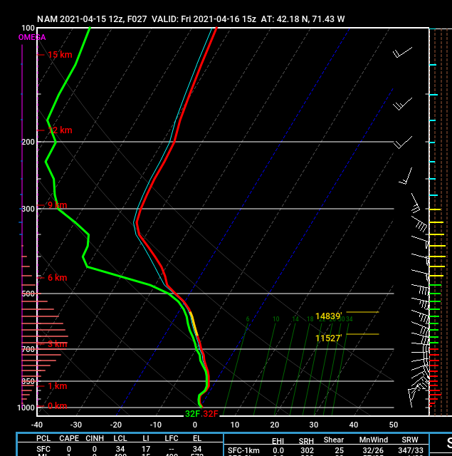
LOL, this isthe NAM sounding over me at 15z tomorrow. Look at that cross-hair sig
-
Just make sure you move into those areas I highlighted for you on the north and west sides of the city. There can sometimes be a big difference between them and the south or southeast side at lower elevation. Although since you are moving from near Philly, it will all seem a lot snowier regardless.
-
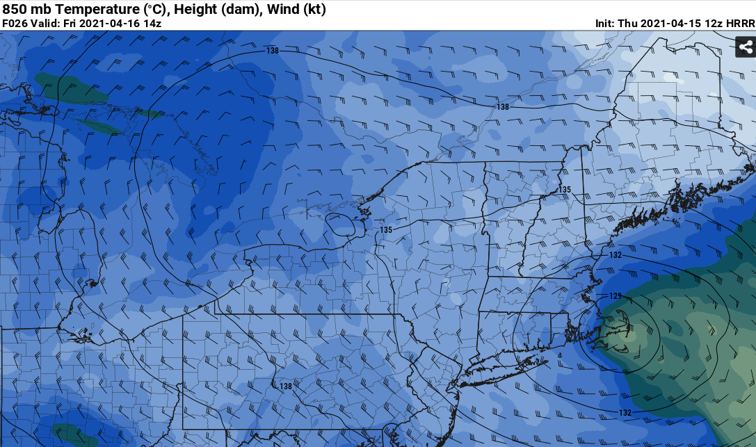
Yeah getting 495 zone pretty good this run whereas previous runs were more confined to the farther interior hills.
-
12z HRRR is pretty awesome looking tomorrow morning.
-
Prob get some decent convection right near the edge of the dryslot.
-
Yeah the 06z run looks a lot more favorable for snows over 128-495 than the 00z run did.
-
Yeah I thought it might paste 128 with like 12-15" based on everything I saw in the midlevels and QPF fields. That is still ridiuclous though for 4/16.
-
Jackpot might be Monads or N ORH county above 1000 feet. You can prob find a parking spot at 1300-1500 feet in New Ipswich and get smoked.
-
RPM trying to come around but not quite there yet. Gets ORH county though.
-
Ray ripping RA+ at 40F while Holliston is parachuting a foot of snow at 32F?
-
Ginxy needs to post the clown map of that one just to save for the archives
-
That is just a ridiculous solution. The rate of deepening on the midlevels is insane. It's like a cross between 12/9/05 and May 1977.
-
Oh my god....I just saw the 06z Euro. That is a total grid collapser across a large swath of MA/RI/E CT
-
Yes. My worry is actually we get the initial band of precip around 00z to 09z late Thursday/early Friday and then it shuts off because the main stuff is offshore and then it backs in from the east but it does so up north because it whiffs us with the wide turn. The initial dryslot is going to punch in from the southwest and then it will try and stall as the precip starts moving in from the east with the upper low closing off south of us. But if that happens too late, then you miss out on the goodies. That’s why I was telling Kevin yesterday that I was worried about slotting down in CT and not wanting to trade too much latitude.
-
RGEM didn’t move too much. It tickled SE but not enough for a big dog solution over most of SNE. It is still an impressive solution for ORH county up into S VT and Monads.
-
Yeah no doubt. If that same storm happened 12 hours difference, it prob dumps 20-30% more snow due to better ratios. But it’s still pound town even during the day on a NAM setup. And 1987 shows that when you get the omega, it doesn’t matter that much when it happens.
-
I’ve mentioned this before but the bulk of April 28-29, 1987 was between noon and 6pm. Peak heating time. ORH still had 17” and like 8-12” all through BOS suburbs.
-
That’s where Scooter should be looking this run...his grid will be collapsed for weeks if that happened.
-
The 3km is a piece of work too this run.
-
There’s actually several SREF members that look similar to the NAM. There was a notable shift SE on the 21z run.
-
A Blue Hill birch bender.
-
LOL it might even crush BOS itself midday Friday this run. Gonna have to save this run.
-
Wow that hammers E MA even (at least BOS suburbs) Friday morning.
-
NAM is coming in a solid tick SE. we’ll see what it does in the next panel or two.
-
I just fired up a thread before the 00z runs. We know at least some people in this forum will get hit hard so it’s time to have a thread for it.