ORH_wxman
-
Posts
90,902 -
Joined
-
Last visited
Content Type
Profiles
Blogs
Forums
American Weather
Media Demo
Store
Gallery
Everything posted by ORH_wxman
-
September Discussion Thread: Bring the frost; kill the bugs.
ORH_wxman replied to moneypitmike's topic in New England
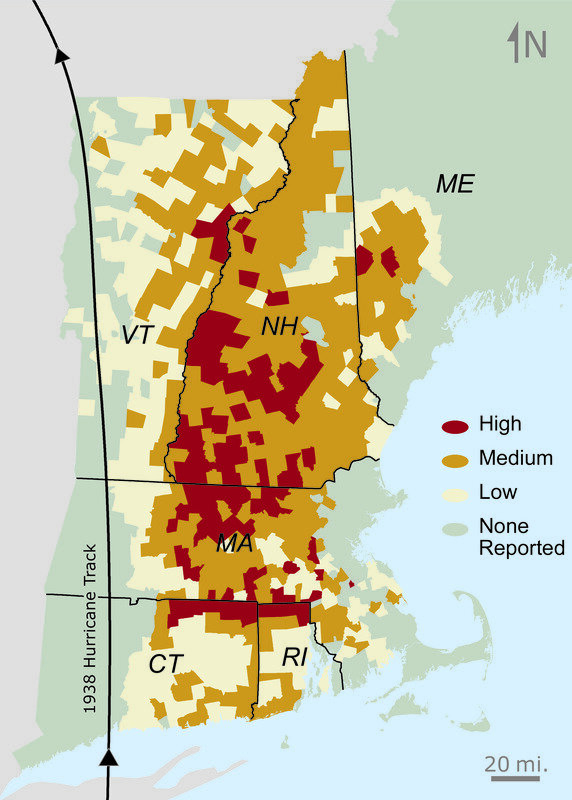
That's a pretty cool image, but it's modeled, so I try and stay with empirical obs. Here's another from Harvard....it shows damage by town...obviously there's some gaps in this analysis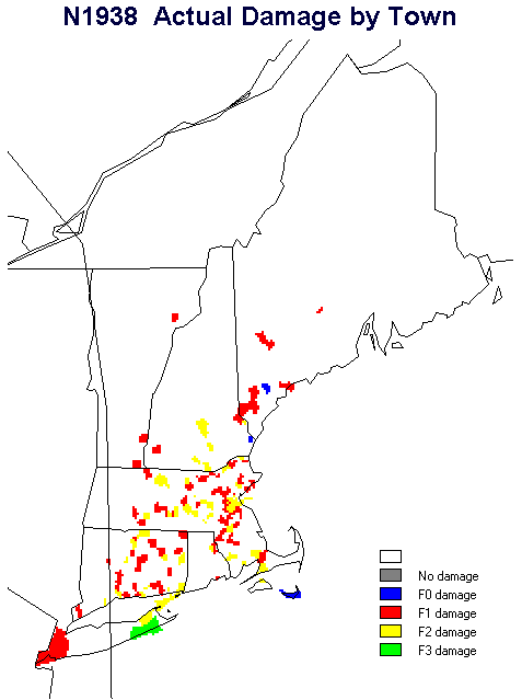
-
September Discussion Thread: Bring the frost; kill the bugs.
ORH_wxman replied to moneypitmike's topic in New England
This image is from the harvard forest archives...the max damage definitely is a little west of, say, BOS, but it is focused over E CT/RI/C MA/E-central MA. It seems to taper some back near the CT river in MA (but not in NH)
-
September Discussion Thread: Bring the frost; kill the bugs.
ORH_wxman replied to moneypitmike's topic in New England
Well even west of ORH got in on the wind core...so I should probably say "central MA" too...so places like Palmer/Ware would have been in it....but typically the worst winds on a more tropical system would have been over the CT river but in this case it was over central/east-central MA and E CT/RI. -
September Discussion Thread: Bring the frost; kill the bugs.
ORH_wxman replied to moneypitmike's topic in New England
Yes it was...it was a minimal cat 3 at landfall in RI. -
September Discussion Thread: Bring the frost; kill the bugs.
ORH_wxman replied to moneypitmike's topic in New England
Carol was smaller than '38 too...it was more tropical and had an intact eyewall at landfall whereas the '38 storm was going extratropical with baroclinic assist....which why the worst winds in 1938 were over eastern MA/E CT/RI even though the center actually tracked over western CT and western MA near the NY border. -
My guess is we finish around 10th or 11th lowest on extent, but there is an outside chance we finish 13th with only 2009 and 2013 being above 2021 since the 2007 event if the weather cooperates enough and more of Beaufort ice hangs on.
-
That's for extent, but for area, we've seen August minimums. I believe 1992 was 8/31 and 2005 used to have an 8/30 min but recent revisions to the NSIDC database now has 9/3 as barely edging out 8/30 for the min. But 8/23 is ridiculous for a min....if an August minimum on area would occur, it would be around the last day or two of the month.
-
September Discussion Thread: Bring the frost; kill the bugs.
ORH_wxman replied to moneypitmike's topic in New England
The cool shot on the Euro next week looks nice. Gonna feel like fall. -
We've fallen below the 8/23 value on NSIDC area. The 8/23 value was 3.38 million sq km and today we are at 3.26 million sq km. 8/23 wasn't a very realistic minimum date.
-
Maybe KGAO can catch the eastern eyewall. That’s prob the station to watch going forward. Too bad there isn’t one right on Grand Isle. They h e an airport but no obs come out of there.
-
DLP obs is over 30 min old though...wonder if they croaked too.
-
KDLP 291310Z AUTO 12075G96KT M1/4SM FG 25/25 A2917 RMK A01
-
This is even more impressive. On the west side of the storm KMDJ 291150Z AUTO 02083G102KT M1/4SM FG BKN002 OVC019 26/26 A2858 RMK A01
-
KDLP 291135Z AUTO 09067G85KT 3/4SM BR SCT003 BKN014 BKN021 25/25 A2930 RMK A01
-
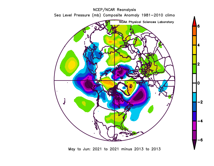
You can't get a meaningful ice recovery on the Siberian side without being able to hold the multi-year ice in the Beaufort first. The Beaufort Gyre circulates the ice up toward the Chukchi and East Siberian Sea, but if the MYI is melting out in the Beaufort during the summer, then it makes any type of longer term recovery impossible. As for the ice retention patterns......2013 was probably the best ice retention pattern we've seen in the past decade. If you subtract 2013 pressure anomalies from 2021 for the crucial pre-conditioning months of May/June, you can see how 2021 had higher pressures over the CAB (esp the PAC/Beaufort side) while having lower pressures over the Kara....a worse pattern than 2013.
-
I don't think we've reached the NSIDC area min....that would be like a week earlier than the previous earliest min. There is still plenty of low concentration ice in the Beaufort/Chukchi that should bring us down a bit further. That said, I don't expect a very big drop like 2010 had....the weather looks really cold up there on the models over the next week.
-
The Cleveland superstorm was a bust too...was originally going to be eastward and be a lot of snow up here.
-
Finally got a little gust that caused some damage
- 713 replies
-
- 11
-

-

-
This is really lame. Not much up on the hill here either for wind. It’s now or never for gusts....really between now and 3-4pm. We’re seeing temps/dews rise a bit into the low 70s so that may try to help the good 925 winds mix down, but the clock is ticking.
-
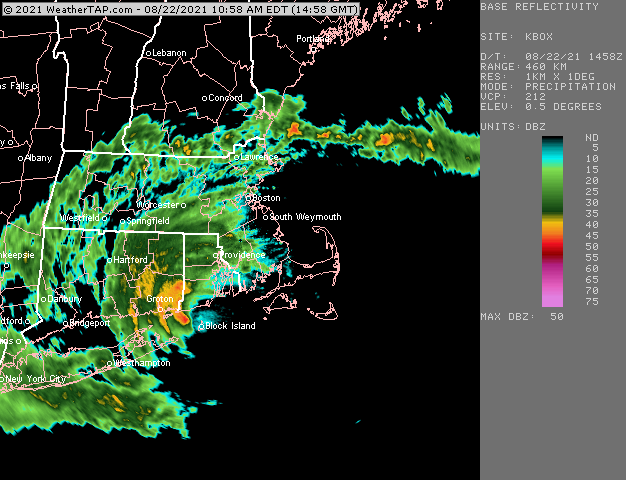
Hard to say, the center is kind of broad. It certainly came close enough to say it basically crossed BID.
-
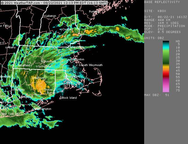
Almost looks like there are two centers, lol...Looks like low level circulation there coming onshore east of WST and then another near GON
-
Looks like the center is just N of BID but still offshore the mainland.
-
Looks like BID might be getting grazed by the west side of the center.
-
Yeah 40-50 will bring down a decent number of limbs with the wet foliage all over them. A few trees being uprooted with the soggy ground are likely too. I'm just hoping to keep power, but the grid on this hill is about as good as the CT grid.
-
I'm thinking like 40-50mph gusts here. Best window looks like about noontime to 3ish. That's when the best combo of LLJ and weak inversion trying to break occur. Can't rule out some higher gusts if we get a good squall to mix the winds down, but I don't think 60+ would be widespread around here.