

ORH_wxman
-
Posts
90,902 -
Joined
-
Last visited
Content Type
Profiles
Blogs
Forums
American Weather
Media Demo
Store
Gallery
Everything posted by ORH_wxman
-
October Discussion: Bring the Frost-Hold the Snow
ORH_wxman replied to 40/70 Benchmark's topic in New England
My only quibble with this month. I love these types of days but it would have been nice to sneak in a quick cold shot a week or two ago that kills the bugs. But otherwise let’s keep the party going. I got no use for 52/27 type days unless I’m doing yard cleanup or something. -
Looks like their maximum snow depth was 100 inches in 2011-2012....they reached 107 inches in the 1989-1990 winter. Yeah most of their epic years aren't good here, though there are some exceptions. 2012-2013 was their 5th snowiest winter on record and it was very snowy in New England (not so much in the mid-atlantic though). 2000-2001 and 1976-1977 were also top 10 snowiest winters in Valdez which were prolific in New England.
-
Valdez had 438" of snow that season. 4th snowiest on record. 1989-1990 had 550" (!!)
-
I was in elementary school....it wasn't a huge deal over the interior, but it was windy and rainy for several days. I do remember all the news footage of the coastline though getting smoked with the huge tides and surf. The Perfect Storm actually did quite a bit of damage to the outer sand bank at Chatham which had first been breached in the '78 storm. But that '91 damage set the stage for the December 1992 storm to rip it open much more a little over a year later.....the rest is history as the erosion has really increased without that outer sand bar protecting it.
- 13 replies
-
- 1
-

-
- perfect storm
- halloween gale
- (and 1 more)
-
Yes...agree. We've had plenty of fairly snowy winters with temps above normal. Most notable was probably 2012-2013....but even last year (at least over the interior of SNE) had pretty good snows even though temps came out to slightly above average. BOS would have too if they didn't get the epic shaft on the 2/1 storm. But just a gut feeling that this year is gonna have some really cold airmasses in Canada that get us every now and then....I'm feeling a cold La Nina profile.
-
We're due for a cold winter....even in the context of CC (the 30 year moving averages offset some of the longer term difficulty in attaining normal temps). If we go by DJFM, the last one was 2017-2018 (though NNE was below normal for temps in 2018-2019....but not SNE which was average), and then you have to go back to 2014-2015 to get another.
-
October Discussion: Bring the Frost-Hold the Snow
ORH_wxman replied to 40/70 Benchmark's topic in New England
Something happened with their high temps back in 2019. Look at how the yellow dots (high temps) have a step-change in late 2019...the low temps don't seem affected too much: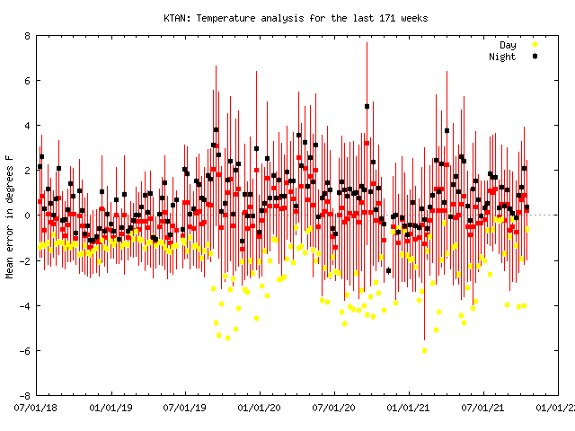
-
October Discussion: Bring the Frost-Hold the Snow
ORH_wxman replied to 40/70 Benchmark's topic in New England
ORH only got down to 31F during that October stretch, so I don't think BOS was wrong in 2009. We know both BOS and ORH don't radiate, so if ORH only managed 31F, then BOS didn't get below freezing. -
October Discussion: Bring the Frost-Hold the Snow
ORH_wxman replied to 40/70 Benchmark's topic in New England
The whole point of the shield and fans is to remove that bias. ASOS temps are taken in the shade too...the thermometer is inside a little box. The entire bias will never be totally removed because the ambient air is probably affected too much by the sun hitting darker surfaces near the ASOS, but it shouldn't be more than a degree or so even taking that into account if it is properly sited away from the pavement. -
EPS are starting to show it too near the end of the run...you can see how the N PAC is definitely shuffling. It could be rushed, but I'm leaning toward the change....it fits a lot of La Nina climo anyway.
-
October Discussion: Bring the Frost-Hold the Snow
ORH_wxman replied to 40/70 Benchmark's topic in New England
Latest 32F by station: BOS: 12/6 (2009) ORH: 11/12 (1977) BDL: 11/11 (1920) PVD: 11/19 (1935) -
October Discussion: Bring the Frost-Hold the Snow
ORH_wxman replied to 40/70 Benchmark's topic in New England
Do you mean 36F? Official frosts are not tracked...they use 36F as the marker, but we all know 36F comes in many different flavors and many won't produce frost. Freeze is a lot easier...it's just first date of 32F -
October Discussion: Bring the Frost-Hold the Snow
ORH_wxman replied to 40/70 Benchmark's topic in New England
Growing season is over in all of NNE and it's over in most of MA too....so they won't issue any advisories in those spots going forward. -
Pretty decent displacement of the stratosphereic vortex looks progged....toward Siberia. That should be very good for enhancing cryospheric generation there. As for pattern change in November? Not sure when that might happen, but the weeklies do have a noticeable change around the 2nd week of November.
-
Recency bias.
-
October Discussion: Bring the Frost-Hold the Snow
ORH_wxman replied to 40/70 Benchmark's topic in New England
I think the 70s are done after tomorrow. At least for a while....next week doesn't look warm at all on the Euro. GFS tries to cut the late week storm to our west which would warm sector us for a day or so, so we'll see what happens there. Euro CADs New England though with high pressure nosing down. -
October Discussion: Bring the Frost-Hold the Snow
ORH_wxman replied to 40/70 Benchmark's topic in New England
Yeah there’s a lot of years down there where it’s almost a shutout. Maybe a couple 1-4” events and that’s it. It can be brutal for snow lovers. That said, it probably makes you appreciate the snow more. There’s plenty of people here who bitch at 8” snowstorms because they didn’t get 17”. -
2pm Saturday, 11/20 @ Funky Murphy's ORH
ORH_wxman replied to 40/70 Benchmark's topic in New England
I might be able to make this one. No guarantees, but optimistic. -
October Discussion: Bring the Frost-Hold the Snow
ORH_wxman replied to 40/70 Benchmark's topic in New England
Next week will definitely have some chillier days. Might be two cold pushes....one Sunday through Tuesday....then maybe a relaxation Wed/Thu and then another next weekend. We'll see how it plays out. I wish Sunday's cold push was a little stronger....ideally we'd get a hard freeze either Sun night or Mon night to kill the bugs and then go back to above normal temps, but it looks more like lows in the 30s and not quite a freeze except for the typical rad spots. -
2009-2010 wasn't "Cold" here...it was slightly above average. But 2015-2016 was an absolute furnace. '09-'10 was cold though over a large portion of the country that does not include New England. December 2009 was quite cold. Like for ORH, December was about -1.5 departure, January was almost dead average, and Feb was +2 so it averages out to a pinch above normal but 2015-2016 was +12 (all time warmest December), +2.5, and +3.5....which makes the entire winter 6 degrees warmer than 2009-2010.
-
The 2009-2010 and 2015-2016 winters were not alike at all. 2009-2010 was cold across most of the conus including into the mid-Atlantic and southeast...even if where we were was a bit above normal. It was a lot snowier than 2015-2016 too across most of New England. The patterns were completely different.
-
October Discussion: Bring the Frost-Hold the Snow
ORH_wxman replied to 40/70 Benchmark's topic in New England
No, all the stations with longer periods have record highs of 85+ for today. -
October Discussion: Bring the Frost-Hold the Snow
ORH_wxman replied to 40/70 Benchmark's topic in New England
Correct. PEople need to distinguish between what "They think" and what the official thresholds are. For NWS tracking, 33-36F is a frost. -
October Discussion: Bring the Frost-Hold the Snow
ORH_wxman replied to 40/70 Benchmark's topic in New England
12/16/07. That storm will live in infamy. I had a 3-6” forecast back then (and I was a little more bullish than other outlets)...only took about 3 hours to get obliterated. -
October Discussion: Bring the Frost-Hold the Snow
ORH_wxman replied to 40/70 Benchmark's topic in New England
Huge December and then it faded somewhat...esp south of pike. Same winter where we had the epic traffic disaster in the December 13th storm that came in like a wall mid/late morning.
