ORH_wxman
-
Posts
90,902 -
Joined
-
Last visited
Content Type
Profiles
Blogs
Forums
American Weather
Media Demo
Store
Gallery
Everything posted by ORH_wxman
-
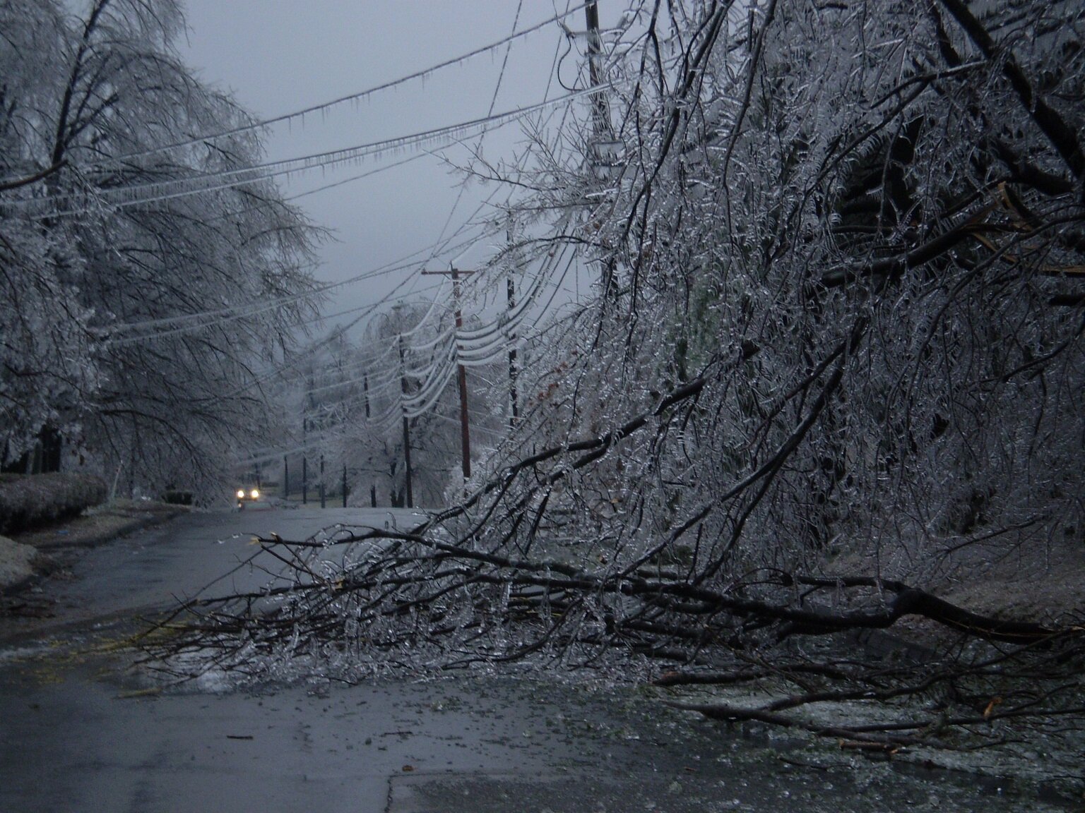
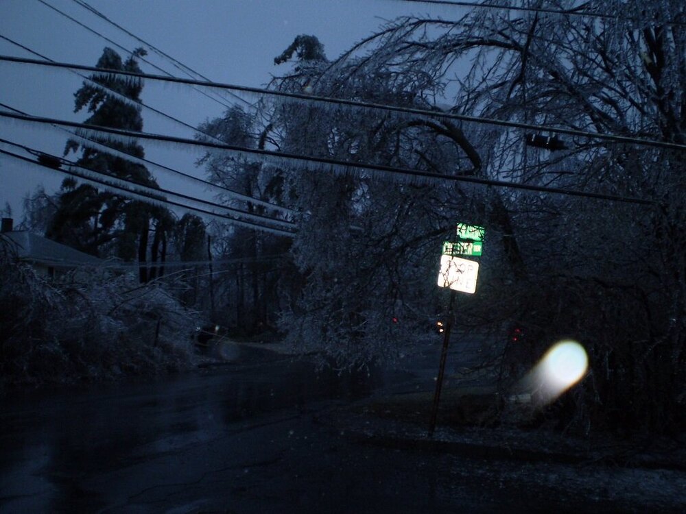
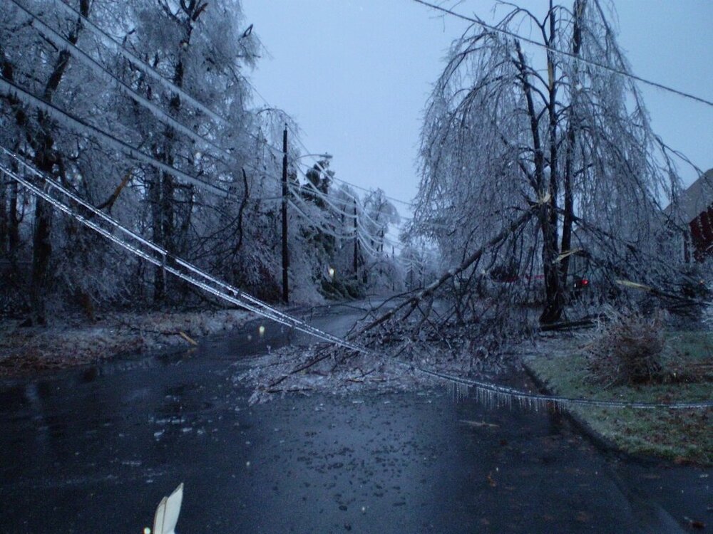
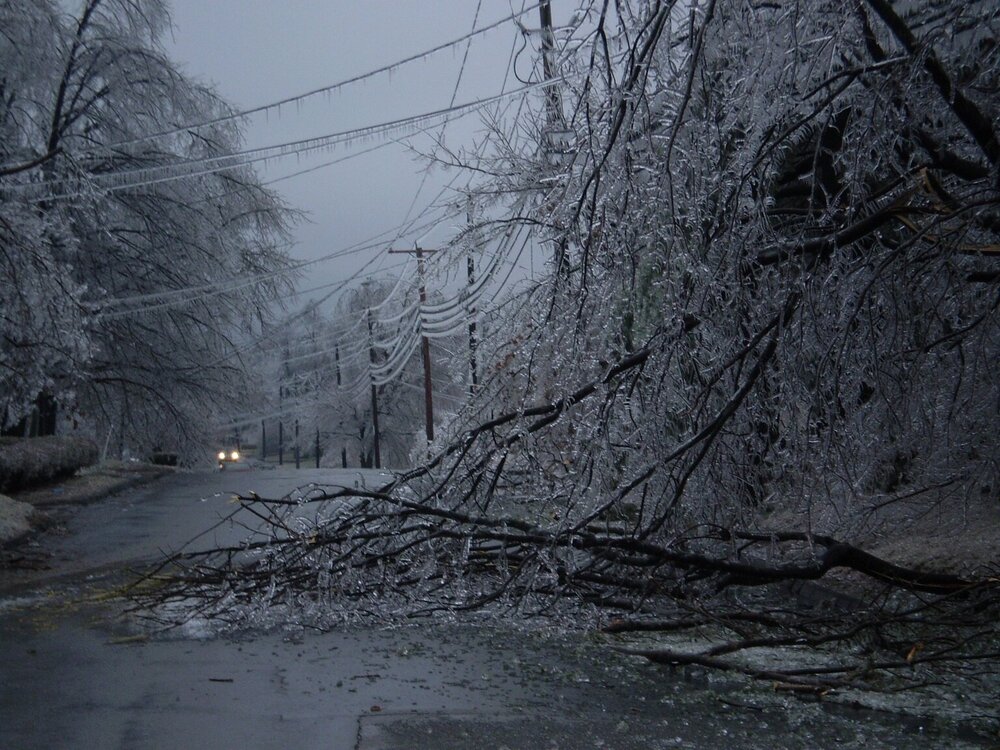
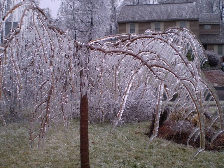
The damage line was amazing. It literally sliced ORH in half....the south side of the city had very little icing except the hills above about 600 feet there. But up on the north side of the city, the icing damage was pretty bad all the way down to 500-550 feet. Most of the north side of the city is 600+ feet anyway, but even the lower parts were bad..and of course as you went up 190 it was awful even down to 300-350 feet in the lowest parts of Fitchburg/Leominster.
-
14F up on MWN....good indicator of the airmass. Solid cold for this time of the year....nothing extreme, but a good cold shot....like 5 to 8F below normal for highs.
-
"I'm only asking for a once in 50 to 100 year event"
-
Yep, the funny part about that was about an hour or two earlier, i had gone for a walk and noticed the ice accreting decently, but still a decent amount of runoff of the water. I made the comment on the forum "I think we dodged a bullet"....but then all hell started breaking loose not long after that....LOL. I lost power like 20 minutes after that post, and then another hour or so after that the shotgun blasts started. Here's a couple more from that one....I'll have to go back and post all of them again at some point since the old forum is where they used to be and it doesn't exist anymore.
-
Yep, this is always my favorite pic I took during the storm....look at the icicles....they are not pointing straight down. The wind ripping from 20 knots out of the northeast did that
-
It's possible it was was 11/13/04 too, but that one didn't have much, if any, ice north of the CT/MA border. There was a little down in CT I think.
-
Massive juiced southern stream system slamming up into a marginal polar high in Quebec. It had very solid ageo flow. The only reason it wasn't way worse for areas closer to Boston and down into CT/NRI was the airmass was just a little too marginal. The synoptic setup was good though...and we even had a mesolow that forms to the east of BOS and went into the gulf of Maine....if the airmass had been like 2-3F colder, then even into metro Boston prob would have had a lot of ice and the 128 belt would have been decimated....and certainly your area to Kevin's too....but both of you missed out by like 0.5-1F....razor thin margin. Here is the loop: http://www.meteo.psu.edu/fxg1/NARR/2008/us1212.php
-
Prob Nov 16, 2002. That was actually a pretty big ice storm for the elevations of N CT and far S MA. We had some ZR in ORH but a lot of sleet too so it wasn't as icy as just a bit south.
-
I remember going outside on Winter Hill during that one and seeing it immediately when I went outside. Didn't even have to wait for my eyes to adjust to the dark.
-
You already know this....but for those that don't: Unfortunately very rare in New England....you almost need one of those "due south wind" type events where everything is eroding but someone like Chris up in Greenfield rots at 30F for several hours with ZR and a place like ORH is 40F. But usually those type of events are very transitory....the ZR changes to rain within a few hours. The longer duration ZR events up here all require strong ageostrophic northerly flow and usually that means it's going to be strong through the lower 2000-2500 feet in the atmosphere, so we end up with higher elevations actually doing better until you reach like 2500-3000 feet or so when the temp starts rising again.
-
Really heavy frost here.
-
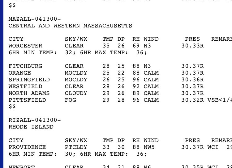
6 hourly shows 32
-
I think it’s 11/12/77. Maybe the 13th. Can’t remember now. The weaseled a 32 on the nose last night so this year won’t break that record. ORH is running a bit warm right now too.
-
You had like 15-18" in 3/13/18
-
Maybe the tip of Cape Ann isn't. But most of it would be in the 50 zone. They can be kind of boom or bust there. There's also no way you didn't break 30" in 2017-2018. The 1/4/18 and 3/13/18 events alone almost get you there....then add events like Xmas 2017, Feb 17-18, Mar 7-8 and then other random 2-4" type events
-
I'd prob draw SNE to look more like this (I rushed this just now, so I didn't put in as many obsessive details as usual)

-
Yeah it's all bogus north of BOS....those north shore towns should be over 50....unless maybe you are literally out in the ocean like the tip of Cape Ann or maybe some of those communities near Marblehead. The 75+ should also extend down to far NW CT in Litchfield county and you could prob put a 100-spot or two in the northern Berkshires on the crest there over 2000-2500 feet.
-
Also the sub-25 zone on the Cape is fake. The only place that may come close to not averaging 25" in SNE is near GON....but even there is suspect for 1991-2020 since that region had a really good run recently.
-
Agreed....the 75" should come down to almost ORH airport (they were 72.8" on the latest 1991-2020 avg) along the spine there in Princeton/Rutland. Also, prob shouldn't have that sub-50" zone in 495...that is totally fake. Prob a bad coop or two affecting that plot in there.
-
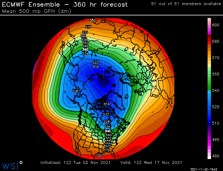
Can see the signs of change near the end of the EPS for later in the month, we'll have to see how this tracks....whether it starts amplifying or getting pushed back some. Often, a pattern change can be rushed a bit by guidance so we'll see.
-
March really throws it off...but most of us in New England already know that March is a big part of our snow climo. Those 1991-2020 April numbers almost certainly too low too since they aren't including April 1996 and 1997 (both over 20") as those were part of the ASOS blackout years.
-
ORH 1991-2020 averages: Oct: 1.1" Nov: 1.9" Dec: 14.9" Jan: 18.2" Feb: 21.1" Mar: 13.7" Apr: 1.9" Total: 72.8" DJF: 54.2"
-
There's a weak inverted trough trying to set up for Thursday night, so it's possible some folks could see their first flakes if there's enough moisture/lift to squeeze out some flurries or a snow shower. Other than that, pretty boring through mid-month, gets mild again before perhaps a change in the final 1-2 weeks of the month. Ensembles and the weeklies still showing this.
-
BOS went back to being biased warm in their ASOS. Not sure what the issue is. ORH would prob be closer to 5th if the siting didn’t change in 1948. Several of the warmer autumns were at the old site which was warmer than the airport.
-
MQE - #4 ORH - #9 PVD - #2 BDL - #6 BDR - #2