ORH_wxman
-
Posts
90,902 -
Joined
-
Last visited
Content Type
Profiles
Blogs
Forums
American Weather
Media Demo
Store
Gallery
Everything posted by ORH_wxman
-
I just wait and then blow them all into the woods. I might do one refresher Tday weekend to get the stragglers but I’m not blowing leaves when the oaks are still clinging to 30-50% of their foliage.
-
10-18-09
-
I think the GSM went out to 4 or 5 says but the LFM was 48 hours. Or maybe 60. Not sure.
-
There were computer models but they weren’t very good. There was the GSM (global spectral model) and then in the 1970s they added the LFM (precursor to the NGM/ETA)
-
Why is modellab stuck on 06z
-
Accumulating snow for SE MA while Kevin gets rain in CT?
-
I'd actually probably take Dec 1970 over both. The first 4 or 5 days torched and then all hell broke loose and it never stopped. March 2001 is also prob better than either 1993 or 2018 if we're talking about Methuen.
-
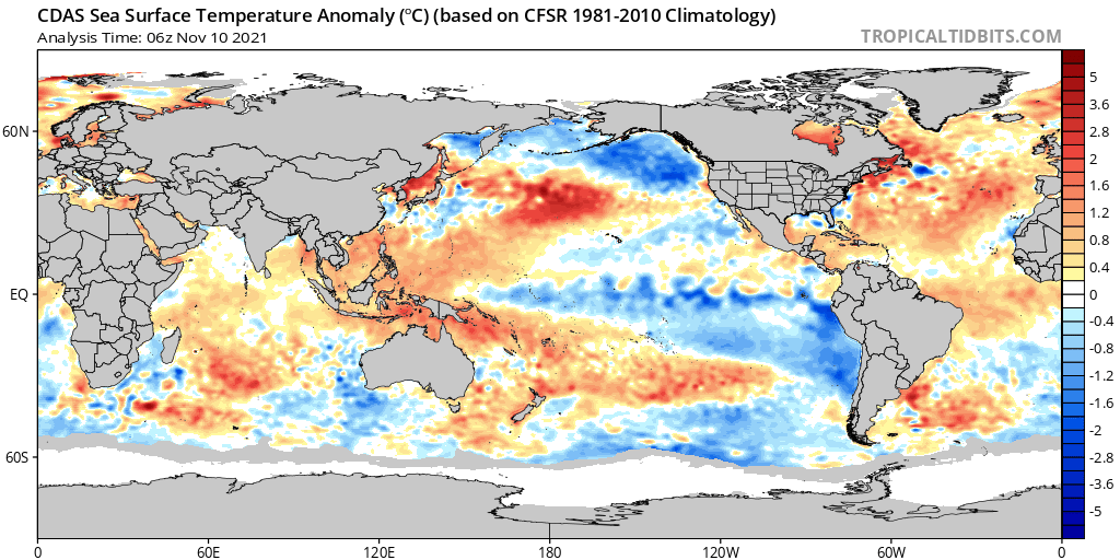
This looks more like a La Nina than any of the other previous ones we've had since 2011.
-
If the winter is not a combination of December 1995, January 2011, February 2015, and March 1993, it's a failure.
-
I didn't see any real changes overnight to the D6 threat. As for late November, the guidance has been slowly warming because of eroding blocking up in the WPO/EPO region, but I wouldn't sweat it too much. It's not like there is a death vortex up there.
-
You prob had snow OTG in 1989? We basically didn’t go above freezing for like 3 weeks straight that month, lol...it wasn’t a very snowy month, but the snow that did fall didn’t go anywhere. The coast did get a little tainted in 12/15/89 event but I still think you got 3-4”. The interior managed snow pack on Xmas in both 1991 and 1992 as well. 1992 was the glaciated remains of the Dec 1992 storm but it was bulletproof, lol.
-
Yeah we were spoiled for a while there. Paying the piper a bit recently. I noticed Hingham had a rough stretch between 1976-1988. 11 out of 13 brown Xmas and 16 out of 19 between 1976-1994.
-
Hingham technically snuck in with 1" at obs time. But maybe they had 8am obs time...id have to look up their specs.
-
I may have officially still had an inch or two of slush at 7am last year....but it was so disgusting I'm not even counting that as a white Xmas. It was funny because Xmas eve was amazing....like 50-55 but still a foot of snow OTG and filtered sun. My boys were outside most of the day playing in it and we had a fire going in the fire pit outside. It was quite festive....almost a Reggae-fest atmosphere you see at ski areas in late March on those warmish days. If it weren't for the horrific rainstorm that started later that night, it probably would have just been a typical warm day that melts 3 inches of pack but not much else.
-
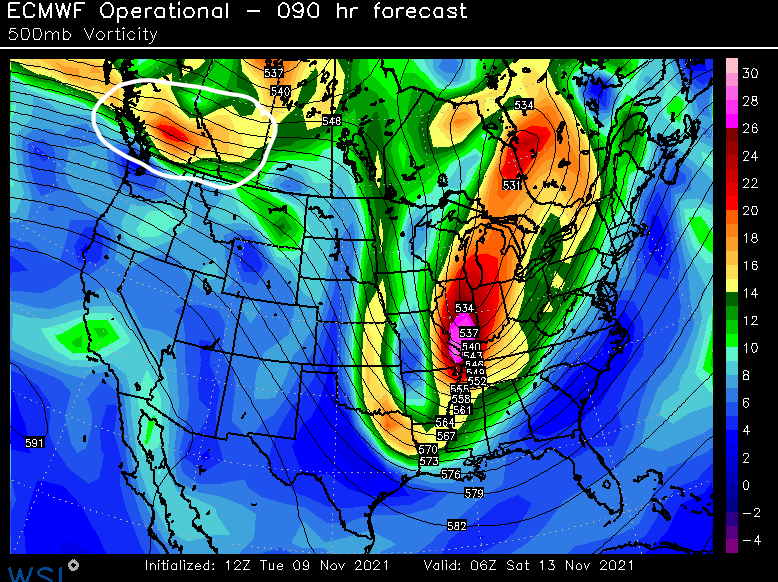
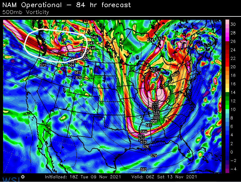
Getting back to the "threat" next week....as Tip said, this wave is probably going to cause some model waffling. It comes in screaming on kind of a "flat" flow. You can see it here at 90 hours on the Euro And even now the 84 hour NAM at 18z "sees" the wave as well. This is the one to watch....you have the lead deep trough out ahead of it and that wave will try to amplify into the back side of that large trough. That's kind of what you are looking for this early in the season because you typically want some fresh CAA to put a decent antecedent airmas in place. It's not the greatest airmass, but might be enough for interior and esp elevations. Something to watch at least....we'll see if it is still there in another 48 hours.
-
On the flip side, there were some places (mostly S of pike) that did not get a white Xmas in 2002 because they had bare ground and the snow didn't start accumulating until about 8-9am in spots. So that was deceptive too. I think some spots in far SE MA had this happen in 2017 too...the rain flipped to snow there around 7am but they didn't have an inch yet...so it officially goes down as a brown Xmas even though they prob were snowing 2" per hour between 7-9am.
-
For ORH, White Xmas happened in 2000, 2002, 2005, 2007, 2008, 2009, 2010, 2012, 2013, 2017, 2019. That's 11 out of 21...so a little over 50%. if we use the Hingham coop in place of BOS since BOS doesn't keep snow depth data any longer, then we have white Xmas in 2000, 2002, 2007, 2008, 2009, 2010, 2012, and 2017. That's 8 out of 21 or just under 40%.
-
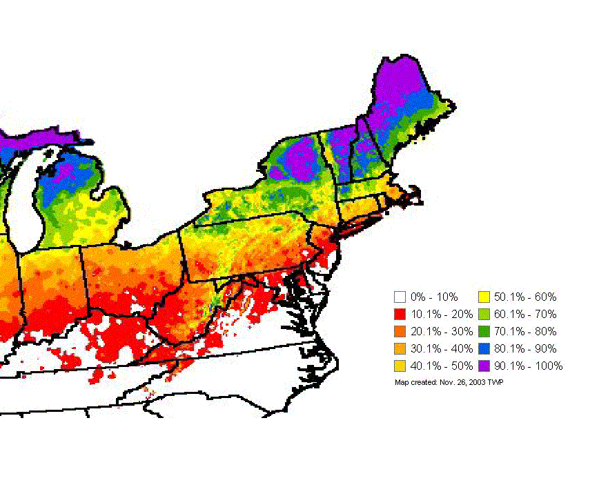
Old climo map I had on my files:
-
ORH is about 60-65%....BOS (keep in mind that is logan in the harbor) is about 20-25%. Most of metro-west like 128 to 495 is prob closer to the 40-50% range.
-
Something cooking on the Euro at D6....GGEM showed this too but the GGEM was more for NNE elevations. Euro might be for SNE too.
-
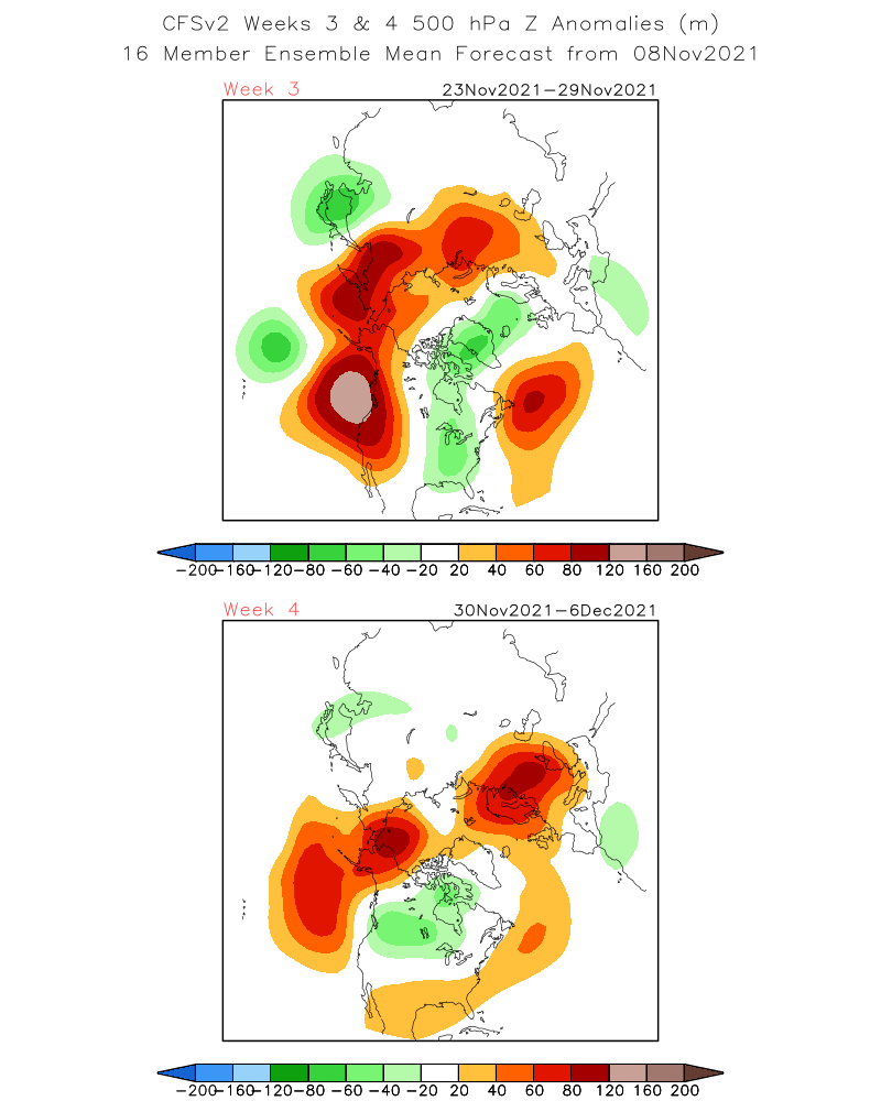
The week 4 map has the WPO block little bit west of ideal, but given the time frame, it’s prob fine for now. You shift that a touch East and we’re in business for December. Also, Atlantic doesn’t look terrible...get that a little more blocky and we’d have more wiggle room. And goes without saying...things could shift in a less favorable direction too. But most of the guidance is definitely going with the theme of dumping some frigid air into Canada...CFSv2 likes it too...has the higher heights up north further east which is what we’d want.

-
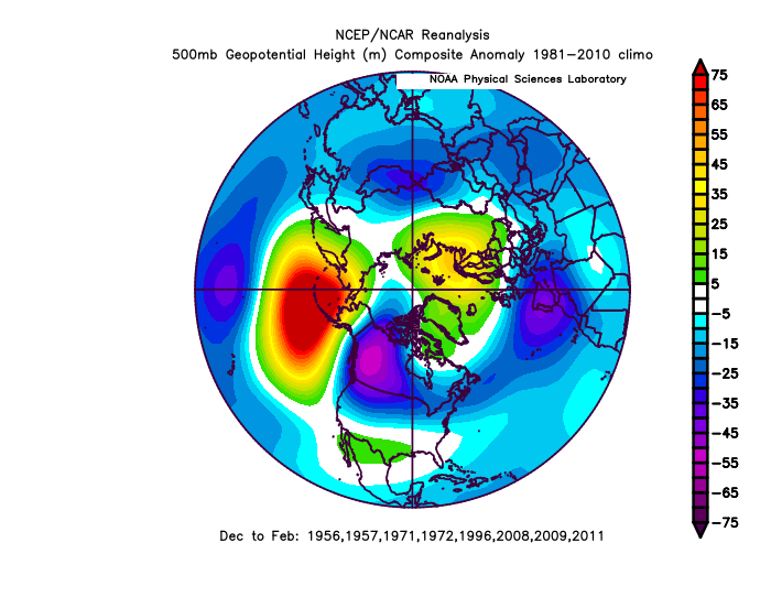
If you have a La Nina winter with a severe -PNA where the core of the low height anomalies is over the PNA region in western Canada, the key to having it still be a very good winter is the WPO region to the west and also not having a hostile Atlantic. I made a composite below of the "good" La Ninas that had this general PNA pattern:
-
Gonna freeze there again. Amazing.
-
It would be worth it if you were preserving a snow pack. But it’s the worst when there’s no tangible benefit to the cold.
-
Those temp anomaly maps look like a crappy El Niño. Lol.