ORH_wxman
-
Posts
90,902 -
Joined
-
Last visited
Content Type
Profiles
Blogs
Forums
American Weather
Media Demo
Store
Gallery
Everything posted by ORH_wxman
-
December 2021 Obs/Disco...Dreaming of a White-Weenie Xmas
ORH_wxman replied to 40/70 Benchmark's topic in New England
Still not liking the EPS in the 11-15....need a little more ridge amplification in the PAC to press that cold down. It's not far away from being good...central and western Canada are frigid....this isn't like a 2011 or 2015 furnace across the entire continent where the source is gone and on the other side of the pole...it's lurking, but we don't want to get stuck on the wrong side of the gradient. -
December 2021 Obs/Disco...Dreaming of a White-Weenie Xmas
ORH_wxman replied to 40/70 Benchmark's topic in New England
Another chance D10....pretty active pattern. -
December 2021 Obs/Disco...Dreaming of a White-Weenie Xmas
ORH_wxman replied to 40/70 Benchmark's topic in New England
You'll want that high to hang on a little longer than shown....which it might. Way too far out for details. The thing could be hundreds of miles different by next week. But verbatim, that high sliding east starts to turn the BL into a problem inside 128/I-95. -
December 2021 Obs/Disco...Dreaming of a White-Weenie Xmas
ORH_wxman replied to 40/70 Benchmark's topic in New England
Pretty classic SWFE on Euro. High end advisory to low end warning for much of MA and into NH/VT and S ME...N CT may be ok too on that run. -
December 2021 Obs/Disco...Dreaming of a White-Weenie Xmas
ORH_wxman replied to 40/70 Benchmark's topic in New England
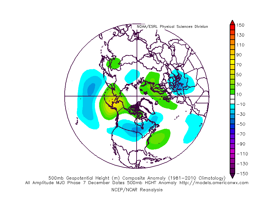
Yeah I'm hoping we see a trend more toward the -EPO look that the MJO composite phase 7 maps have as we move closer. It was especially strong on Ray's Nina composite. If that does happen, then we really just have to deal with the turd pattern for a week or less. -
December 2021 Obs/Disco...Dreaming of a White-Weenie Xmas
ORH_wxman replied to 40/70 Benchmark's topic in New England
Oh nice...mine wasn't Nina-specific, but yeah, its the same idea. That's a very storng signal N of AK which would be good for us. That would shove the gradient south some compared to current guidance. If we can shove that gradient south about 1-2 degrees of latitude from current guidance, then we'd prob be in decent shape. The GEFS haven't been as bad in the LR as the EPS and the OP GFS. Feels like the OP GFS has been consistently ugly out in D11-15....but the GEFS are not. -
December 2021 Obs/Disco...Dreaming of a White-Weenie Xmas
ORH_wxman replied to 40/70 Benchmark's topic in New England
You can prob fold up the tent in NYC for a while....unless something lucky happens. It's going to be a gradient pattern....further north the better. Even SNE may struggle in this, but we'll see as we get closer to mid-month. -
December 2021 Obs/Disco...Dreaming of a White-Weenie Xmas
ORH_wxman replied to 40/70 Benchmark's topic in New England
MJO phase 6-7 for December is usually a decent look and it usually supports ridging in AK and not troughing. We'll see if that ridging trying to show up near EPO region mid-month becomes stronger as we get closer. Forecasts are for us to go from phase 6 to phase 7. Maybe scooter has some thoughts on the convection, but the two baseline December maps aren't bad....phase 7 does support some SE ridging but it's kind of weak.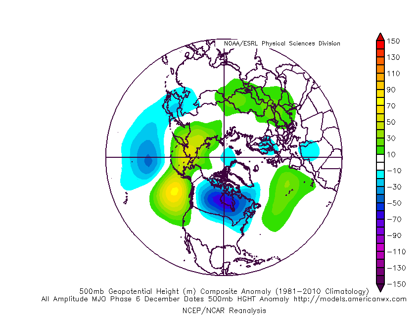
-
December 2021 Obs/Disco...Dreaming of a White-Weenie Xmas
ORH_wxman replied to 40/70 Benchmark's topic in New England
The weird part is as Scott said...it wasn't a warm November there. I assume BDR is the closest site to him and they were actually a -1.7 departure for the month. But being close to the shore definitely makes for a much longer growing season. -
December 2021 Obs/Disco...Dreaming of a White-Weenie Xmas
ORH_wxman replied to 40/70 Benchmark's topic in New England
His climate seems like Florida. He can run a fruit orchard in the winter. -
December 2021 Obs/Disco...Dreaming of a White-Weenie Xmas
ORH_wxman replied to 40/70 Benchmark's topic in New England
https://en-gb.topographic-map.com/ Just type any location in the search bar and then you can zoom in or out. I accidentally had the bar at the top set to (English - UK)....just change it to US and it will appear in feet and not meters. edit: here is the US link https://en-us.topographic-map.com/ -
December 2021 Obs/Disco...Dreaming of a White-Weenie Xmas
ORH_wxman replied to 40/70 Benchmark's topic in New England
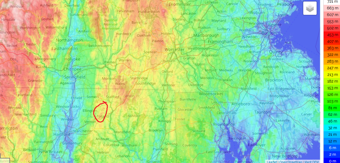
Yeah his area is W facing...but not all of the NE CT hills are....up in Union and over toward Woodstock, they are more favorable on easterly flow. -
December 2021 Obs/Disco...Dreaming of a White-Weenie Xmas
ORH_wxman replied to 40/70 Benchmark's topic in New England
I would say you are definitely more west-facing than anything....maybe WNW.
-
December 2021 Obs/Disco...Dreaming of a White-Weenie Xmas
ORH_wxman replied to 40/70 Benchmark's topic in New England
It's the terrain influence....west slopes will do better on those setups with the winds turning W behind the front. -
December 2021 Obs/Disco...Dreaming of a White-Weenie Xmas
ORH_wxman replied to 40/70 Benchmark's topic in New England
Kevin will be back on the badnwagon by Friday 12z at the latest. One of these next few cycles will start honing in on a threat. He will flip from dustings to 6-10" just like he flipped from "no snow through Xmas" to 4-8" for November 29th last week. -
December 2021 Obs/Disco...Dreaming of a White-Weenie Xmas
ORH_wxman replied to 40/70 Benchmark's topic in New England
18z NAM trying to make the clipper on Saturday more interesting. A lot of the SREFs did the same this run....still not much, but if that trend is real, then it wouldn't take much more to drop a couple of inches. -
VR better not f*ck Wildcat up....that's one of the few "pure skier's mountains" left in New England with that type of vertical.
-
December 2021 Obs/Disco...Dreaming of a White-Weenie Xmas
ORH_wxman replied to 40/70 Benchmark's topic in New England
Screaming winds -
December 2021 Obs/Disco...Dreaming of a White-Weenie Xmas
ORH_wxman replied to 40/70 Benchmark's topic in New England
Your mixing up 2017-2018 and 2018-2019....1/4/18 was the huge storm. In 2019, our one big one was 3/4/19 (esp for SE areas). We had several moderate events though in Jan/Feb that year but they favored more interior than where you are. -
December 2021 Obs/Disco...Dreaming of a White-Weenie Xmas
ORH_wxman replied to 40/70 Benchmark's topic in New England
No shortage of SWFE opportunities next week on the Euro. They might not work out but the chances are there. Beats something like the first 10-12 days of Dec 2018 IMHO....when we were sitting there in a cold pattern waiting for a single storm and watched central Virginia get 18" of snow and then the pattern flipped and we ran the table the rest of the month with nada. -
December 2021 Obs/Disco...Dreaming of a White-Weenie Xmas
ORH_wxman replied to 40/70 Benchmark's topic in New England
Hopefully we have a few more Quebec highs than that season. That is what really separated that year from something snowier like 2007-2008. -
December 2021 Obs/Disco...Dreaming of a White-Weenie Xmas
ORH_wxman replied to 40/70 Benchmark's topic in New England
Lot of western troughing though so that would make cutters a high risk...which this run has a lot of. On the flip side, there's some pretty good antecedent airmasses so there's some front enders and any of them could trend a lot colder...esp at the sfc. I think it could be pretty good for NNE....not sure on SNE though. -
December 2021 Obs/Disco...Dreaming of a White-Weenie Xmas
ORH_wxman replied to 40/70 Benchmark's topic in New England
Lol....dryslot took the bait -
December 2021 Obs/Disco...Dreaming of a White-Weenie Xmas
ORH_wxman replied to 40/70 Benchmark's topic in New England
Except in January when we needed more gradient.....lol -
December 2021 Obs/Disco...Dreaming of a White-Weenie Xmas
ORH_wxman replied to 40/70 Benchmark's topic in New England
Yeah it was really the 12/19 storm...you could count the ice storm on 12/11-12/12 if you wanted to but it only affected part of the interior and it torched a couple days later for a couple days. 2008 is actually an example of a marginal pattern with a ton of cold in Canada that ended up producing despite not a lot of cold down in New England in the means. We were like +2 that month IIRC. But it was very active and with cold lurking around we got 2 or 3 systems timed correctly.