

ORH_wxman
-
Posts
90,902 -
Joined
-
Last visited
Content Type
Profiles
Blogs
Forums
American Weather
Media Demo
Store
Gallery
Everything posted by ORH_wxman
-
December 2021 Obs/Disco...Dreaming of a White-Weenie Xmas
ORH_wxman replied to 40/70 Benchmark's topic in New England
Fast flow with no blocking is hard to get double digit totals. It can happen but it’s thread the needle. Advisory to low end warning much easier to obtain in fast flow. -
December 2021 Obs/Disco...Dreaming of a White-Weenie Xmas
ORH_wxman replied to 40/70 Benchmark's topic in New England
Nobody should be expecting a foot from this thing. Everything would have to go perfect. -
December 2021 Obs/Disco...Dreaming of a White-Weenie Xmas
ORH_wxman replied to 40/70 Benchmark's topic in New England
Yep it’s going to come back north. Even the crushed solutions show how much WAA is still happening with not very amplified energy. -
December 2021 Obs/Disco...Dreaming of a White-Weenie Xmas
ORH_wxman replied to 40/70 Benchmark's topic in New England
Helped us last year in February. -
December 2021 Obs/Disco...Dreaming of a White-Weenie Xmas
ORH_wxman replied to 40/70 Benchmark's topic in New England
A typical banana high classic for locking in cold to the coastline is an arc from N of Maine to the Great Lakes region.....not from N Maine to the Atlantic....the latter configuration will still lock in the CAD over the interior, but it will definitely set up a CF somewhere near or west of 128/95 and allow marine air to infiltrate a chunk of the CP. -
December 2021 Obs/Disco...Dreaming of a White-Weenie Xmas
ORH_wxman replied to 40/70 Benchmark's topic in New England

-
December 2021 Obs/Disco...Dreaming of a White-Weenie Xmas
ORH_wxman replied to 40/70 Benchmark's topic in New England
The pattern in clown range is totally different than 12 hours ago. Popping a temporary EPO ridge and flooding the CONUS with arctic air. -
December 2021 Obs/Disco...Dreaming of a White-Weenie Xmas
ORH_wxman replied to 40/70 Benchmark's topic in New England
Even more comical is the warmup between 12z Thu and 18z Thu...despite winds going almost due north on a trajectory from dendrite's fanny to ORH....it must think the diurnal heating over interior New England has the same enery per sq meter as Mercury or Venus. -
December 2021 Obs/Disco...Dreaming of a White-Weenie Xmas
ORH_wxman replied to 40/70 Benchmark's topic in New England
Yeah that ain't happening with that sfc low track. -
December 2021 Obs/Disco...Dreaming of a White-Weenie Xmas
ORH_wxman replied to 40/70 Benchmark's topic in New England
Yeah that banana needs to be rotated counter clockwise about 90 degrees. -
December 2021 Obs/Disco...Dreaming of a White-Weenie Xmas
ORH_wxman replied to 40/70 Benchmark's topic in New England
I love how embedded the N trend is in everyone's head for these events. -
December 2021 Obs/Disco...Dreaming of a White-Weenie Xmas
ORH_wxman replied to 40/70 Benchmark's topic in New England
Unless the high position drastically changes (which is still possible), the sfc will almost undoubtedly trend colder based on where it is N of CAR. Model bias 101....eroding the sfc cold too fast, esp when a stout arctic high straps its fanny into a row boat in the St LAwrence seaway near Quebec City. -
December 2021 Obs/Disco...Dreaming of a White-Weenie Xmas
ORH_wxman replied to 40/70 Benchmark's topic in New England
Too late...he's already sucked in. -
December 2021 Obs/Disco...Dreaming of a White-Weenie Xmas
ORH_wxman replied to 40/70 Benchmark's topic in New England
I'm looking at the flow around 108 hours and trying to figure out why this won't trend north. The energy on some of these flatter runs is more sheared, but all I can think of is when the energy inevitably comes in a little more organized on future runs, that downstream ridging is going to amp right up. There's no blocking to stop it or slow it down. The progressive nature of the flow is really the limiting factor. -
December 2021 Obs/Disco...Dreaming of a White-Weenie Xmas
ORH_wxman replied to 40/70 Benchmark's topic in New England
Sfc is too warm on the GFS which will definitely screw up the NARCAN maps. Sell the sfc warmth W of 128 with the high just N of CAR. -
December 2021 Obs/Disco...Dreaming of a White-Weenie Xmas
ORH_wxman replied to 40/70 Benchmark's topic in New England
I do like seeing some southerly solutions. This thing is prob gonna trend north with that pig SE ridge so we're prob gonna need some wiggle room. -
December 2021 Obs/Disco...Dreaming of a White-Weenie Xmas
ORH_wxman replied to 40/70 Benchmark's topic in New England
I'd take the GFS even....it's like 3-4" here. Obviously I'd like more, but I wouldn't complain with an advisory snowfall with some ZR mixed in there. -
December 2021 Obs/Disco...Dreaming of a White-Weenie Xmas
ORH_wxman replied to 40/70 Benchmark's topic in New England
A tiny bit of synoptic moisture with that...that's the clipper we were keeping half an eye on. Should be good for the upslope zones. -
December 2021 Obs/Disco...Dreaming of a White-Weenie Xmas
ORH_wxman replied to 40/70 Benchmark's topic in New England
We had like 3 inches of crud (snow changing to IP/ZR) on 12/30-12/31 and then the separate 1/1 event gave us about 3-4"....late bloomer though and got your area much harder. Even near Ray up by NH border I think had 6-8". -
December 2021 Obs/Disco...Dreaming of a White-Weenie Xmas
ORH_wxman replied to 40/70 Benchmark's topic in New England
Yeah and there's no guarantee the pattern is that great in the second half....obviously a lot of the time it comes down to timing. Both 2007 and 2008 weren't great patterns. They were serviceable though and because they were very active, we managed to hit a few events in close proximity when all the cold in Canada bled down over us. We also saw the downside as we had to withstand a cutter or two. Still, those types of patterns are way better than the death vortex over the Bering where there's no cold at all to tap into....ala 2011 and 2015. -
December 2021 Obs/Disco...Dreaming of a White-Weenie Xmas
ORH_wxman replied to 40/70 Benchmark's topic in New England
12/07 turned to shit after the norlun on 12/19-12/20....we got basically all of our snow in a 7-8 day period. We did get a smaller event on 12/31 that mixed plus those advisory amounts up near the NH border in 12/3 (more up in NNE), but the Lion's share of snow fell between 12/13-12/20. I agree we won't be as prolific, but just pointing out that if the pattern actually flips to more favorable sometime between 12/15 and 12/20, there's plenty of time to rack up pretty big numbers. It often only takes a couple events in close proximity (2008 also did this). -
December 2021 Obs/Disco...Dreaming of a White-Weenie Xmas
ORH_wxman replied to 40/70 Benchmark's topic in New England
Yeah I liked that trend. Still would like a tick or two more on beating down that ridge but the trend was there that run. More amplified AK/Aleutian ridge for sure that run. Hopefully we can get away with only a week or less of a junk pattern. If we sneak in a SWFE in 12/8-12/9 even better. -
December 2021 Obs/Disco...Dreaming of a White-Weenie Xmas
ORH_wxman replied to 40/70 Benchmark's topic in New England
It didn’t have a blockbuster signature storm. But it was cold and active which led to prolific monthly totals and deep pack. Btw weeklies definitely look decent going into late Dec and January. They are agreeing with the EPS for now that mid-month is junk. -
December 2021 Obs/Disco...Dreaming of a White-Weenie Xmas
ORH_wxman replied to 40/70 Benchmark's topic in New England
We need the -NAO to show back up for the '70-'71 analog to hit harder....but the PAC def looks similar. '70-'71 didn't have a ridiuclously poleward Aleutian ridge.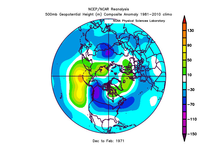
-
December 2021 Obs/Disco...Dreaming of a White-Weenie Xmas
ORH_wxman replied to 40/70 Benchmark's topic in New England
Hopefully we trend that a bit more amplified in AK/Bering


