

ORH_wxman
-
Posts
90,902 -
Joined
-
Last visited
Content Type
Profiles
Blogs
Forums
American Weather
Media Demo
Store
Gallery
Everything posted by ORH_wxman
-
Wednesday 12/8 Possible Snow/Ice/Rain? Discussion
ORH_wxman replied to Torch Tiger's topic in New England
12z guidance has actually been pretty consistent with the exception of the NAM going nuts on the IVT....most other guidance is pretty much in agreement on 1-2" for a larger chunk of the region. There will likely be some areas of enhanced rates but you just don't know where they will be. -
Wednesday 12/8 Possible Snow/Ice/Rain? Discussion
ORH_wxman replied to Torch Tiger's topic in New England
Decent IVT sig over RI/E MA that run. -
December 2021 Obs/Disco...Dreaming of a White-Weenie Xmas
ORH_wxman replied to 40/70 Benchmark's topic in New England
Yeah if we assume the model is handling the polar domains fairly well, I'm figuring we end up decently colder than it shows at least up in the northern latitudes. It's really hard to have a ridge in AK and some ridging in greenland and end up torching....I'm not even sure how that happens at all outside of a temporary cutter or something. -
Wednesday 12/8 Possible Snow/Ice/Rain? Discussion
ORH_wxman replied to Torch Tiger's topic in New England
Oh for sure...if it actually verified...someone would prob get 10-12" fluff bomb from that look. The problem as we've been saying, this might set up 200 miles away too. -
Wednesday 12/8 Possible Snow/Ice/Rain? Discussion
ORH_wxman replied to Torch Tiger's topic in New England
The ingredients are there for a good one...we have deep moisture....not dry above like 800mb, lol. Extremely unstable lapse rates occur too. You just need the LL convergence/lift. -
Wednesday 12/8 Possible Snow/Ice/Rain? Discussion
ORH_wxman replied to Torch Tiger's topic in New England
3km hugs the coast with it....congrats Scooter. -
Wednesday 12/8 Possible Snow/Ice/Rain? Discussion
ORH_wxman replied to Torch Tiger's topic in New England
Soundings become extremely unstable. I mean, this is classic heavy snow sounding from an IVT....I do think there's a decent chance something will set up, but we just don't know where yet.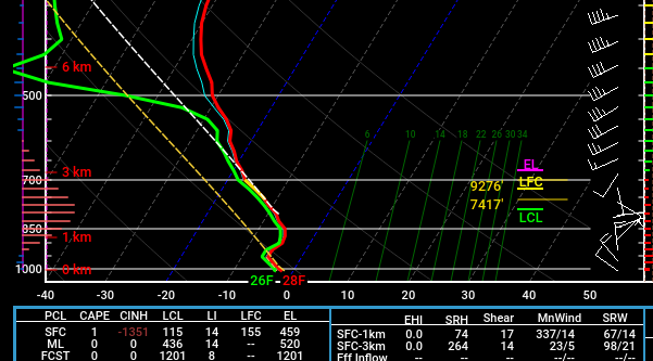
-
Wednesday 12/8 Possible Snow/Ice/Rain? Discussion
ORH_wxman replied to Torch Tiger's topic in New England
NAM gone wild with IVT -
Wednesday 12/8 Possible Snow/Ice/Rain? Discussion
ORH_wxman replied to Torch Tiger's topic in New England
Yeah this is really it....years ago you only had basic QPF maps and had to use experience to interpret snowfall based on thicknesses/mid-level temps, etc.....now you have a trillion weenie snow maps (many of which are awful...in both directions) that every person has access to and it can muddy the discourse quite a bit....esp beyond D5. -
December 2021 Obs/Disco...Dreaming of a White-Weenie Xmas
ORH_wxman replied to 40/70 Benchmark's topic in New England
All guidance is rebuilding the EPO ridge pretty clearly around 12/20....we'll see if that date gets pushed back at all but if it doesn't, I'd expect plenty of winter wx chances in late Dec and into Jan. -
Wednesday 12/8 Possible Snow/Ice/Rain? Discussion
ORH_wxman replied to Torch Tiger's topic in New England
If anything, there is actually an inverse correlation for the winter with Sept/Oct. The warmest Sept/Oct tend to have colder/snowier winters. You don't want November warm though (which it wasn't this year). Just checking Boston really quick....their top 5 warmest Sep/Oct combos coming into this year was 2017, 1971, 2007, 1947, and 1961 (with 1983 close behind). -
December 2021 Obs/Disco...Dreaming of a White-Weenie Xmas
ORH_wxman replied to 40/70 Benchmark's topic in New England
Massive torch incoming for about a week or so starting this weekend...well maybe a brief break with FROPA on Sunday but then it torches for much of next week. EPO ridge rebuilds toward 12/18-20 but there will be a lag on our sensible wx. -
Wednesday 12/8 Possible Snow/Ice/Rain? Discussion
ORH_wxman replied to Torch Tiger's topic in New England
Euro has about 1-2” for eastern half of SNE and more up into Maine. -
Wednesday 12/8 Possible Snow/Ice/Rain? Discussion
ORH_wxman replied to Torch Tiger's topic in New England
Yeah and I think we’re out of time...unless the NAM was a headfake and other guidance comes in beefed up. Best hope for more than 3” is prob someone getting lucky under IVT. -
Wednesday 12/8 Possible Snow/Ice/Rain? Discussion
ORH_wxman replied to Torch Tiger's topic in New England
LOL...doesn’t need to when there’s a trough tickling Cabo San Lucas. Storms through BUF or through Chicago...same difference for us. -
Wednesday 12/8 Possible Snow/Ice/Rain? Discussion
ORH_wxman replied to Torch Tiger's topic in New England
Wow I thought that was coming NW through about 30 hours and then everything just escapes east. There just isn’t enough concentrated energy to take advantage of the sharper trough. Buckshot vorticity FTL. -
Wednesday 12/8 Possible Snow/Ice/Rain? Discussion
ORH_wxman replied to Torch Tiger's topic in New England
There’s nothing obvious. The trough has been trending Southwest on the last few cycles. You really want to see some more concentrated energy...even if a little bit...to help buckle the trough more. We kind of have buckshot vorticity in the flow. -
Wednesday 12/8 Possible Snow/Ice/Rain? Discussion
ORH_wxman replied to Torch Tiger's topic in New England
Yeah even on the euro short term busts like 2/5/16, it comes back pretty slowly. It might make a “moderate” jump in that type of situation but you almost never see it go full-on massive swing in one cycle. We’re running out of time with this one but still can’t rule out a larger moderate/heavy event...but 00z needs to keep coming NW for that to happen. Status quo won’t do. -
Wednesday 12/8 Possible Snow/Ice/Rain? Discussion
ORH_wxman replied to Torch Tiger's topic in New England
It was def better than 12z but it’s incremental. Need a couple more of those to make it a bigger deal...or a larger jump somewhere. -
Wednesday 12/8 Possible Snow/Ice/Rain? Discussion
ORH_wxman replied to Torch Tiger's topic in New England
Yes. That is the baroclinic zone. It’s just the area of thermal gradient where you get all the forcing and rapid development of the low. The way to not have it escape east is to weaken any front running shortwaves or energy and have the backside energy become dominant. This is kind of the issue on the current threat. We don’t have a really defined area of energy (usually seen as vorticity on the 500mb maps)....instead we have some weak impulses embedded in the trough. We really want the vorticity more defined near the base of the trough....that will naturally tend to happen of the trough becomes sharper so that is why we are rooting for that look. -
Wednesday 12/8 Possible Snow/Ice/Rain? Discussion
ORH_wxman replied to Torch Tiger's topic in New England
Might be tough right near water or in an urban heat island with light rates, but the airmass itself isn't exactly marginal. 925 temps are like -5C.....so prob upper 20s interior to near freezing on coast...maybe mid 30s right on the water and that's where most of the accumulation issues might happen in light rates. -
Wednesday 12/8 Possible Snow/Ice/Rain? Discussion
ORH_wxman replied to Torch Tiger's topic in New England
Surprised some of the queens in here didn't point out how much better it was for SE MA than 12z. -
Wednesday 12/8 Possible Snow/Ice/Rain? Discussion
ORH_wxman replied to Torch Tiger's topic in New England
Keeps sharpening up the trough....but you still need it to capture the system without letting the baroclinic zone escape east....and it's still escaping east. You can see how it tries to expand the precip shield back west late in the game though compared to 12z. -
Wednesday 12/8 Possible Snow/Ice/Rain? Discussion
ORH_wxman replied to Torch Tiger's topic in New England
We definitely still need another solid shift NW to make this more than a 1-3 deal for most. It would be nice to get the Euro a little more bullish, but it's been pretty steadfast on the 1" idea with maybe some scattered 2-3" amounts. -
Wednesday 12/8 Possible Snow/Ice/Rain? Discussion
ORH_wxman replied to Torch Tiger's topic in New England
Yeah too early for QPF-queening....maybe by tomorrow 12z.


