ORH_wxman
-
Posts
90,902 -
Joined
-
Last visited
Content Type
Profiles
Blogs
Forums
American Weather
Media Demo
Store
Gallery
Everything posted by ORH_wxman
-
December 2021 Obs/Disco...Dreaming of a White-Weenie Xmas
ORH_wxman replied to 40/70 Benchmark's topic in New England
Looks good north of the pike....but my gut is that one ends up being NNE....we'll see though. -
December 2021 Obs/Disco...Dreaming of a White-Weenie Xmas
ORH_wxman replied to 40/70 Benchmark's topic in New England
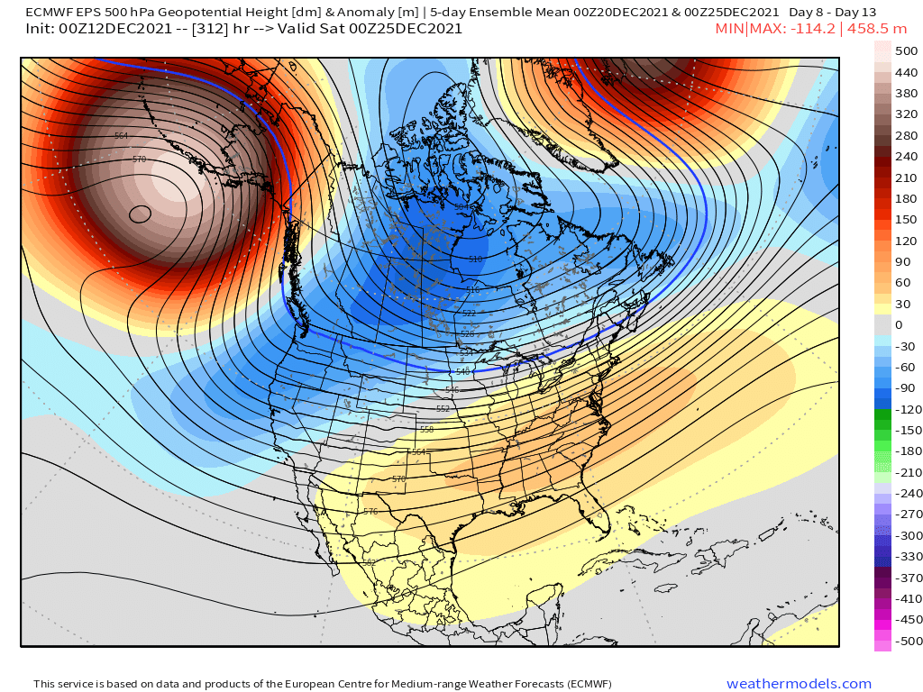
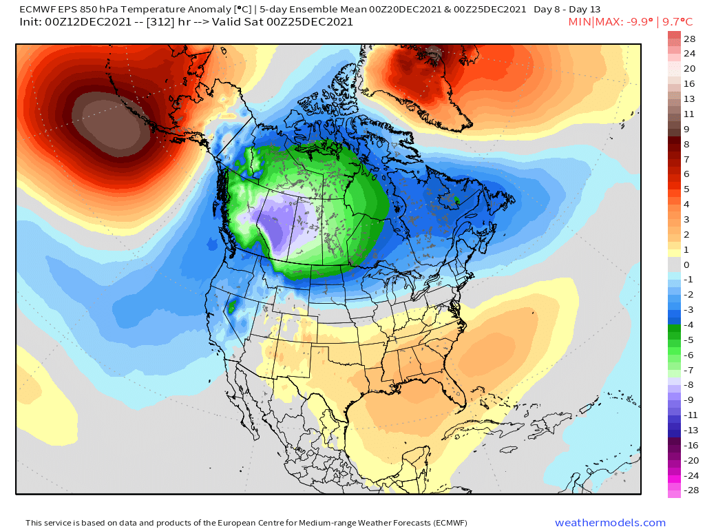
Here’s the 5 day 500mb anomaly mean ending 00z 12/25 and then the 850mb temp anomaly below that for the same time....we’ll have chances with that look but with the SE ridge, cutters are still a risk.

-
December 2021 Obs/Disco...Dreaming of a White-Weenie Xmas
ORH_wxman replied to 40/70 Benchmark's topic in New England
-
December 2021 Obs/Disco...Dreaming of a White-Weenie Xmas
ORH_wxman replied to 40/70 Benchmark's topic in New England
Definitely plausible. There’s pretty decent ensemble support for some potential wintry systems between 12/20-12/24 -
December 2021 Obs/Disco...Dreaming of a White-Weenie Xmas
ORH_wxman replied to 40/70 Benchmark's topic in New England
Euro/GFS/GGEM all have something to watch for 12/20 timeframe. They also have one for 12/18 but it seems like NNE might be the place to be for snow in that one. -
December 2021 Obs/Disco...Dreaming of a White-Weenie Xmas
ORH_wxman replied to 40/70 Benchmark's topic in New England
There’s always plenty of room for a grinch storm in there. Esp with that SE ridge still around. But at least there’s good cold bleeding down and it’s an active jet so we should have chances going forward after next week’s torch. -
December 2021 Obs/Disco...Dreaming of a White-Weenie Xmas
ORH_wxman replied to 40/70 Benchmark's topic in New England
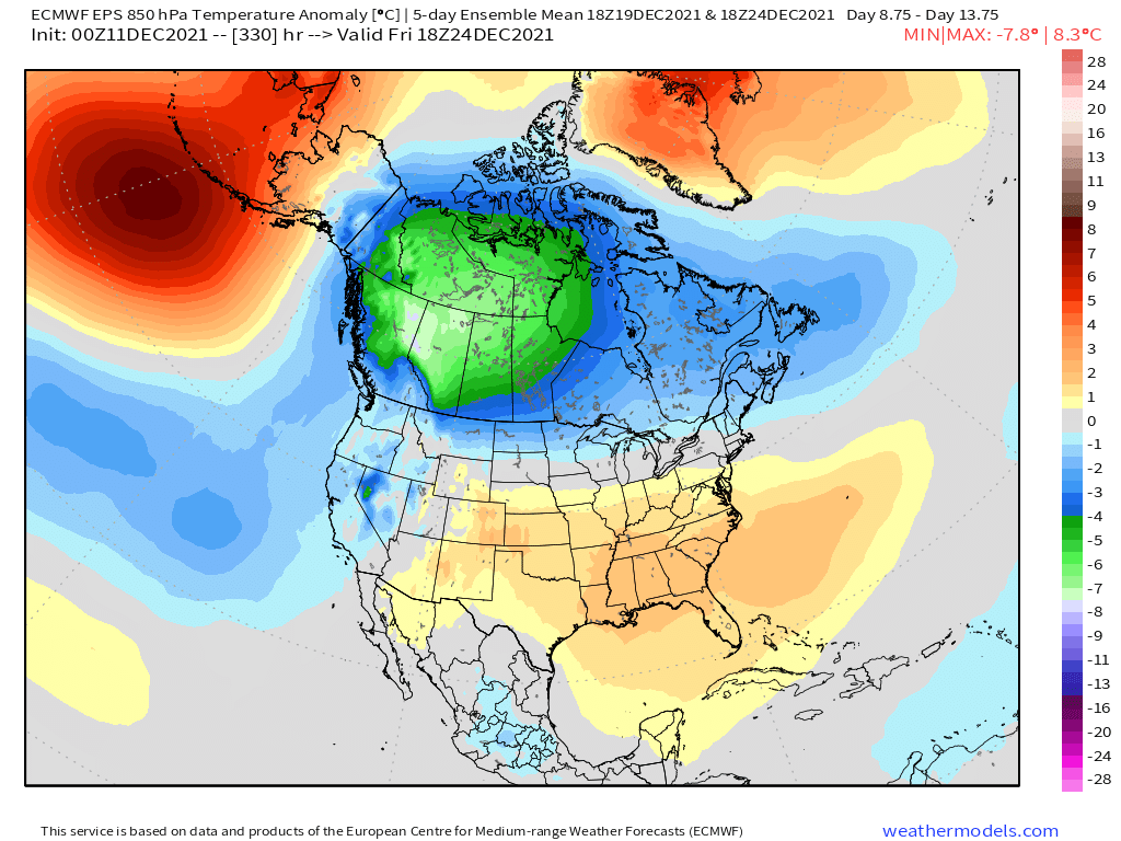
This is the EPS 5 day mean ending 12/24 for both H5 and H85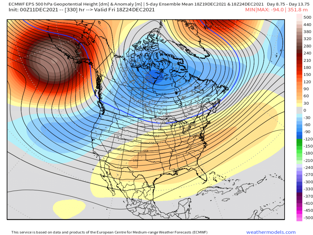

-
December 2021 Obs/Disco...Dreaming of a White-Weenie Xmas
ORH_wxman replied to 40/70 Benchmark's topic in New England
Ensembles on both GEFS and EPS show some potential there in that Dec 19-24 range. -
December 2021 Obs/Disco...Dreaming of a White-Weenie Xmas
ORH_wxman replied to 40/70 Benchmark's topic in New England
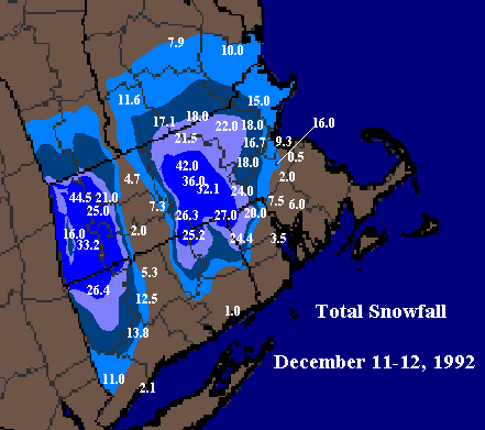
12/22-23/69 had a nasty ice storm over central MA. Prob the one. Dec 1973 is a good mention by the others but that was a full week earlier on the 16th. -
December 2021 Obs/Disco...Dreaming of a White-Weenie Xmas
ORH_wxman replied to 40/70 Benchmark's topic in New England
Yeah gotta go back to 2015 really....though you could maybe make a case for 2018 (first 10 days were brutal cold with the 1/4/18 bomb....however the rest of the month was a torch). Jan 2019 was cold, but not all that snowy. -
December 2021 Obs/Disco...Dreaming of a White-Weenie Xmas
ORH_wxman replied to 40/70 Benchmark's topic in New England
It's clown range but it's a very good look....esp for interior. That high is kind of moving east to coastline might have issues by the time the storm comes up the coast, but overall it's at least something that is plausible once we're done with next week's torch. -
December 2021 Obs/Disco...Dreaming of a White-Weenie Xmas
ORH_wxman replied to 40/70 Benchmark's topic in New England
The 850 anomalies show this well...it's not that warm here.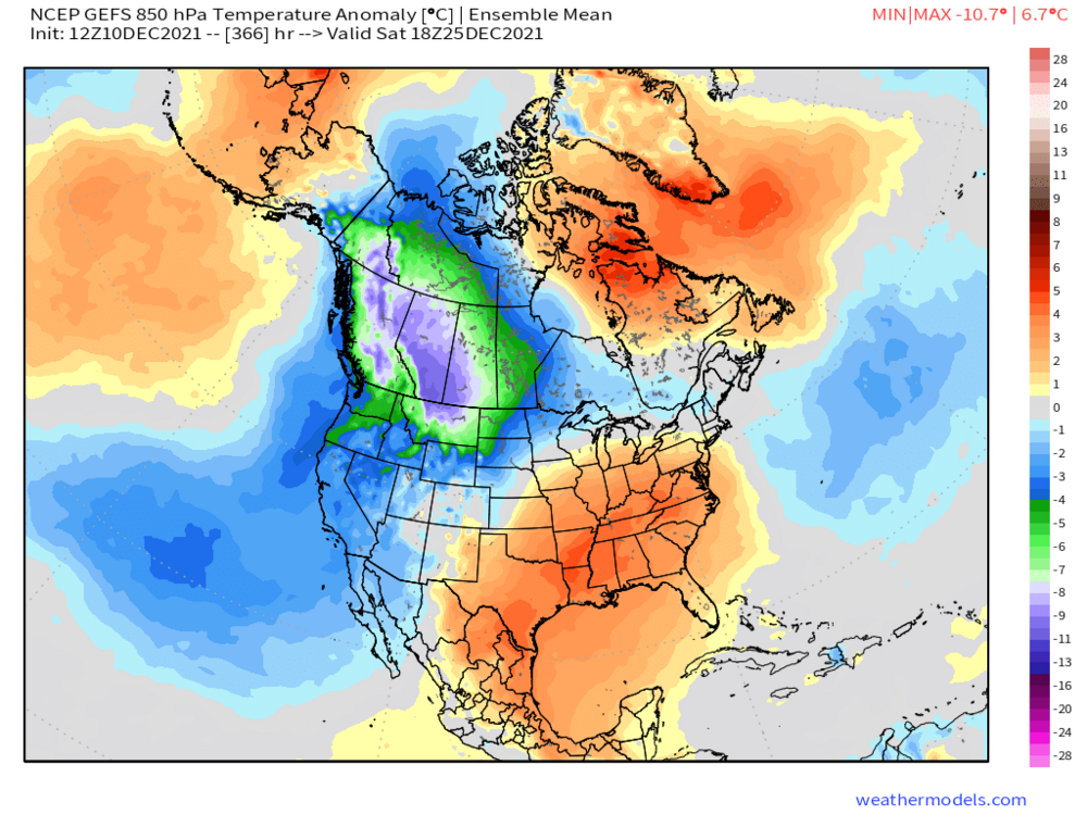
-
December 2021 Obs/Disco...Dreaming of a White-Weenie Xmas
ORH_wxman replied to 40/70 Benchmark's topic in New England
It was a troll post meant to elicit a response. -
I always love reading about the old ski resorts back in the day that relied 100% on natural snow. So many of them were open for like 4-6 weeks all winter. Or even worse in some awful years. A lot of the old mom and pop hills might open for 3-4 weeks in January/February and that would be it. They typically made most of their money during February vacation week so that is the week they hoped to be open.
-
December 2021 Obs/Disco...Dreaming of a White-Weenie Xmas
ORH_wxman replied to 40/70 Benchmark's topic in New England
12z runs so far today definitely have some chances starting around 12/18-19. They would be SWFE type events but it’s obviously a change from the “no chance” regime of the next week. -
December 2021 Obs/Disco...Dreaming of a White-Weenie Xmas
ORH_wxman replied to 40/70 Benchmark's topic in New England
Eh, I think the December composite is probably toast unless we get a huge swing in the final 10 days....too much western troughing and a lot of eastern ridging. -
December 2021 Obs/Disco...Dreaming of a White-Weenie Xmas
ORH_wxman replied to 40/70 Benchmark's topic in New England
Yeah if we're gonna have a really mild day, lets see 70F....55-60 is boring....Thursday could make a run if we warm sector early enough in the day. -
December 2021 Obs/Disco...Dreaming of a White-Weenie Xmas
ORH_wxman replied to 40/70 Benchmark's topic in New England
Yes especially early month....but the 2nd half of the month is pretty decent for snow climo...esp interior. So punting December would be pretty bad....esp in a Nina. I honestly can't remember the last good La Nina where we punted December. Might have to go all the way back to 1971-72. Hopefully this one turns it around in the final 10 days which is very possible. It's an active flow, so the snow events can come in a bunches once some of the timing breaks your way (ala Dec 2007 or 2008) -
December 2021 Obs/Disco...Dreaming of a White-Weenie Xmas
ORH_wxman replied to 40/70 Benchmark's topic in New England
I get the frustration....it's pretty bad to have nothing on the horizon on 12/10.....and we might end up punting all of December until the pattern gets less hostile. I am not quite ready to punt the final 10 days of the month yet though....that's a very strong EPO ridge forecast and if the western troughing is just a little less than shown, we'd have chances I think. But it's definitely a headwind right now. That western trough is very deep. -
December 2021 Obs/Disco...Dreaming of a White-Weenie Xmas
ORH_wxman replied to 40/70 Benchmark's topic in New England
Yeah it was right after that cold tuck event. We had like 3-5” of snow followed by the sleet/ice combo and the ice stayed on the trees for days. -
December 2021 Obs/Disco...Dreaming of a White-Weenie Xmas
ORH_wxman replied to 40/70 Benchmark's topic in New England
2019 was a good one. ORH has a high of 1F. Coldest since the Jan 1994 outbreak which also produced a high of 1F (the Jan 2004 outbreak had a high of 2F). -
December 2021 Obs/Disco...Dreaming of a White-Weenie Xmas
ORH_wxman replied to 40/70 Benchmark's topic in New England
-
Wednesday 12/8 Possible Snow/Ice/Rain? Discussion
ORH_wxman replied to Torch Tiger's topic in New England
Anyone who lived through the late 1980s/early 1990s as a kid should be a grizzled veteran sledding on 2” of snow. -
December 2021 Obs/Disco...Dreaming of a White-Weenie Xmas
ORH_wxman replied to 40/70 Benchmark's topic in New England
I’d be pretty surprised if we cannot beat that in the final 10-12 days of the month considering that monster EPO dump of cold into Canada. Even if the pattern is somewhat hostile for snow, that type of arctic cold is going to be hard to avoid when frontal passages occur behind a cutter....even if it’s transient cold. -
December 2021 Obs/Disco...Dreaming of a White-Weenie Xmas
ORH_wxman replied to 40/70 Benchmark's topic in New England
The SE ridge position in the composite is good for us...the one on the ensembles is bad for us...it's too far north. We could get away with another couple hundred miles even on the composite, but we can't have the max anomalies almost overhead. So if we can trend that western ridge a little more tame and/or find some other mechanism to push the SE ridge a little south (whether its the NAO or a more easterly EPO block), then we'd be in business.