ORH_wxman
-
Posts
90,902 -
Joined
-
Last visited
Content Type
Profiles
Blogs
Forums
American Weather
Media Demo
Store
Gallery
Everything posted by ORH_wxman
-
December 2021 Obs/Disco...Dreaming of a White-Weenie Xmas
ORH_wxman replied to 40/70 Benchmark's topic in New England
Scooter ripping fatties while Kevin is getting scalp-peeler on the GFS. -
December 2021 Obs/Disco...Dreaming of a White-Weenie Xmas
ORH_wxman replied to 40/70 Benchmark's topic in New England
12z GFS is coming in colder too. -
December 2021 Obs/Disco...Dreaming of a White-Weenie Xmas
ORH_wxman replied to 40/70 Benchmark's topic in New England
Starting to look pretty likely. -
December 2021 Obs/Disco...Dreaming of a White-Weenie Xmas
ORH_wxman replied to 40/70 Benchmark's topic in New England
Yeah the Euro suite/ensembles have been trying to pop this a bit before it exits and flip a lot of peeps to snow for a few hours. It looks like the NAM and RGEM may try to go that route if we had another panel or two....esp RGEM more than the NAM...RGEM was already collapsing the 925 low at the end. -
December 2021 Obs/Disco...Dreaming of a White-Weenie Xmas
ORH_wxman replied to 40/70 Benchmark's topic in New England
NAM is like -4C at 925mb along the pike....lol. That would be a scalp-peeling pelletfest here I think. Hoping for a tick colder aloft so it's more snow. -
December 2021 Obs/Disco...Dreaming of a White-Weenie Xmas
ORH_wxman replied to 40/70 Benchmark's topic in New England
There's a pretty good cold drain that may develop during the storm in the low levels. Could be the type of thing where it starts off as rain (or wet snow in northern SNE/CNE)...and then goes to a drier snow further north and pellets/ZR further south where there is still a warm layer aloft, but the cold drain in the low levels is undercutting that. -
December 2021 Obs/Disco...Dreaming of a White-Weenie Xmas
ORH_wxman replied to 40/70 Benchmark's topic in New England
RGEM is also colder than 06z....so we got NAM and RGEM ticking colder. -
December 2021 Obs/Disco...Dreaming of a White-Weenie Xmas
ORH_wxman replied to 40/70 Benchmark's topic in New England
Yeah there are similarities though the PNA is more negative and NAO not quite as west-based, but it's definitely a very favorable pattern. -
December 2021 Obs/Disco...Dreaming of a White-Weenie Xmas
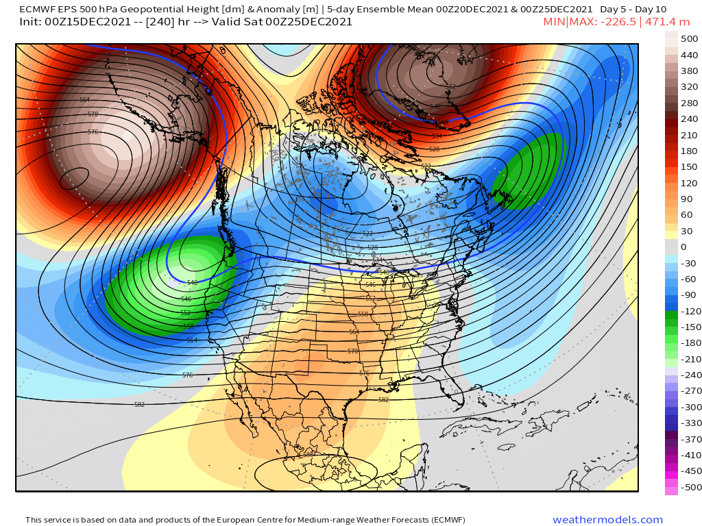
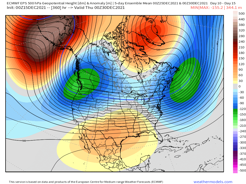
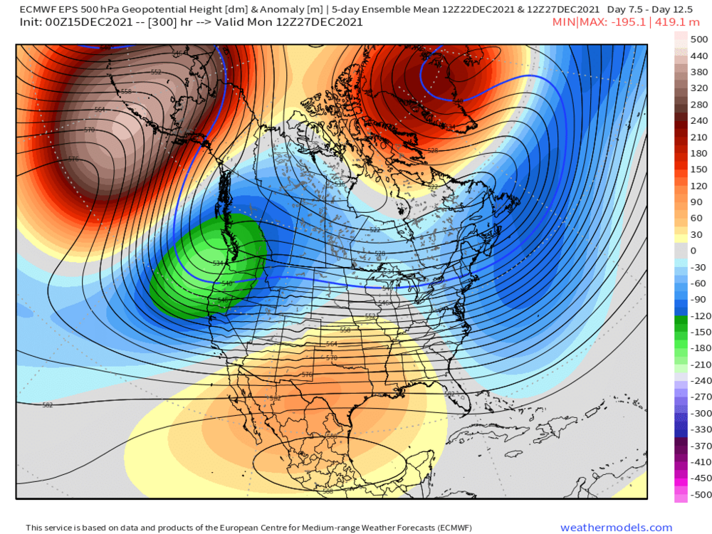
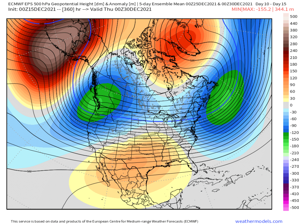
ORH_wxman replied to 40/70 Benchmark's topic in New England
Long range pattern is pretty scintillating on guidance. Hopefully it sticks....because we're gonna cash in on that look if it does. 5 day means at Dec 25, Dec 27, and Dec 30.
-
December 2021 Obs/Disco...Dreaming of a White-Weenie Xmas
ORH_wxman replied to 40/70 Benchmark's topic in New England
There’s definitely room for a ribbon of sleet and ZR because the lower level cold drain is further south than the mid level cold. -
December 2021 Obs/Disco...Dreaming of a White-Weenie Xmas
ORH_wxman replied to 40/70 Benchmark's topic in New England
06z gfs did tickle south again. Euro suite is winning this battle so far. Let’s see if it can throw a shutout or if they win 5-2 or something. Makes a difference for us pike region folks. -
December 2021 Obs/Disco...Dreaming of a White-Weenie Xmas
ORH_wxman replied to 40/70 Benchmark's topic in New England
An inch wouldn’t last 3 or 4 days even in frigid weather. Not enough water content usually to stave off sublimation. -
December 2021 Obs/Disco...Dreaming of a White-Weenie Xmas
ORH_wxman replied to 40/70 Benchmark's topic in New England
Looks like euro was still pretty flat at 18z at the end of the run at 90h....not at the computer though to do a Dprog/dt comparison to 12z...how did it look? -
December 2021 Obs/Disco...Dreaming of a White-Weenie Xmas
ORH_wxman replied to 40/70 Benchmark's topic in New England
Kevin will absolutely lose it if Ray gets a white Christmas and he doesn’t. 2010 MLK style meltdown. -
December 2021 Obs/Disco...Dreaming of a White-Weenie Xmas
ORH_wxman replied to 40/70 Benchmark's topic in New England
Do you mean 12/5? That was that nuking coastal with very little cold air but it managed to flip to snow....ORH had like 10” of paste. We had about 4” of total mashed potatoes here that froze into a glacier the next day. This wont be a nuking coastal like that. -
December 2021 Obs/Disco...Dreaming of a White-Weenie Xmas
ORH_wxman replied to 40/70 Benchmark's topic in New England
Ensembles are warmer than euro OP. Colder than GFS OP though. My guess is still mostly a CNE event at this point but maybe we’ll get lucky and grab an inch or two at the end down here. -
December 2021 Obs/Disco...Dreaming of a White-Weenie Xmas
ORH_wxman replied to 40/70 Benchmark's topic in New England
Yeah it would be two solid wins in a row on events. We’ll see I guess. -
December 2021 Obs/Disco...Dreaming of a White-Weenie Xmas
ORH_wxman replied to 40/70 Benchmark's topic in New England
Yeah seriously. GFS vomited all over itself in the 12/8 event too being way too amped so I’m not buying GFS yet either even though I’d probably lean that way right now. -
December 2021 Obs/Disco...Dreaming of a White-Weenie Xmas
ORH_wxman replied to 40/70 Benchmark's topic in New England
I’ll maybe believe it if there’s good model agreement on it by 12z tomorrow. But I'm still a skeptic for now. I always hate “waiting” for the cold air to drain down during the event. It rarely works out. There are exceptions of course...one of our recent favorites was 10/30/20. -
December 2021 Obs/Disco...Dreaming of a White-Weenie Xmas
ORH_wxman replied to 40/70 Benchmark's topic in New England
Yeah you could tell that was probably going to be a pretty snowy solution if it went another couple frames. There was active cold air drain and the low coming out of the OH valley was already pretty far south so the drain wasn’t going to really stop/reverse. -
December 2021 Obs/Disco...Dreaming of a White-Weenie Xmas
ORH_wxman replied to 40/70 Benchmark's topic in New England
Still a ways out but the clown range NAM looks pretty flat kind of like the euro for this weekend. 18z ICON actually looks like euro except maybe about 10-15 mi north. -
December 2021 Obs/Disco...Dreaming of a White-Weenie Xmas
ORH_wxman replied to 40/70 Benchmark's topic in New England
I wonder if that move made you an even bigger snow weenie...knowing you moved just before the exceptional ‘76-77 and ‘77-78 winters. So when you got back, you relish it even more. -
December 2021 Obs/Disco...Dreaming of a White-Weenie Xmas
ORH_wxman replied to 40/70 Benchmark's topic in New England
It was 1980. There was also an arctic airmass in 1983 but the 1980 one was colder. -
December 2021 Obs/Disco...Dreaming of a White-Weenie Xmas
ORH_wxman replied to 40/70 Benchmark's topic in New England
We had about 6” here. Ripped heavy snow during the morning for about 3-4 hours over a good chunk of SNE. Last Xmas day snowfall before that was about 1” in 2012...saved our white Christmas as we had bare ground the day before. It was a currier and Ives big flake snowfall that lasted about 2 hours between 6-8am or so. We obviously had the big one in 2002 in the interior and then before that you’d have to probably go all the way back to 1978 when about 6” fell on Christmas morning. It actually started very late Xmas eve night before midnight. -
December 2021 Obs/Disco...Dreaming of a White-Weenie Xmas
ORH_wxman replied to 40/70 Benchmark's topic in New England
Yeah you basically get kind of a parade of shortwaves firehosing off the PAC in a -PNA and then the -NAO helps force them underneath us. -PNA/-NAO was the dominating pattern for much of 2010-2011 actually. Ditto 1970-1971 and even for chunks of 2008-2009. You ideally get a couple random +PNA interludes to help amplify a couple systems which did happen even in those winters mentioned....but the base state being -PNA/-NAO keeps the chances rolling in.