ORH_wxman
-
Posts
90,902 -
Joined
-
Last visited
Content Type
Profiles
Blogs
Forums
American Weather
Media Demo
Store
Gallery
Everything posted by ORH_wxman
-
December 2021 Obs/Disco...Dreaming of a White-Weenie Xmas
ORH_wxman replied to 40/70 Benchmark's topic in New England
Yep...I was looking even further into the future....but it's already pretty well established before that....even back to around 84-96 hours it's well under way. D10, it's pretty mature and that's a party time look.
-
December 2021 Obs/Disco...Dreaming of a White-Weenie Xmas
ORH_wxman replied to 40/70 Benchmark's topic in New England
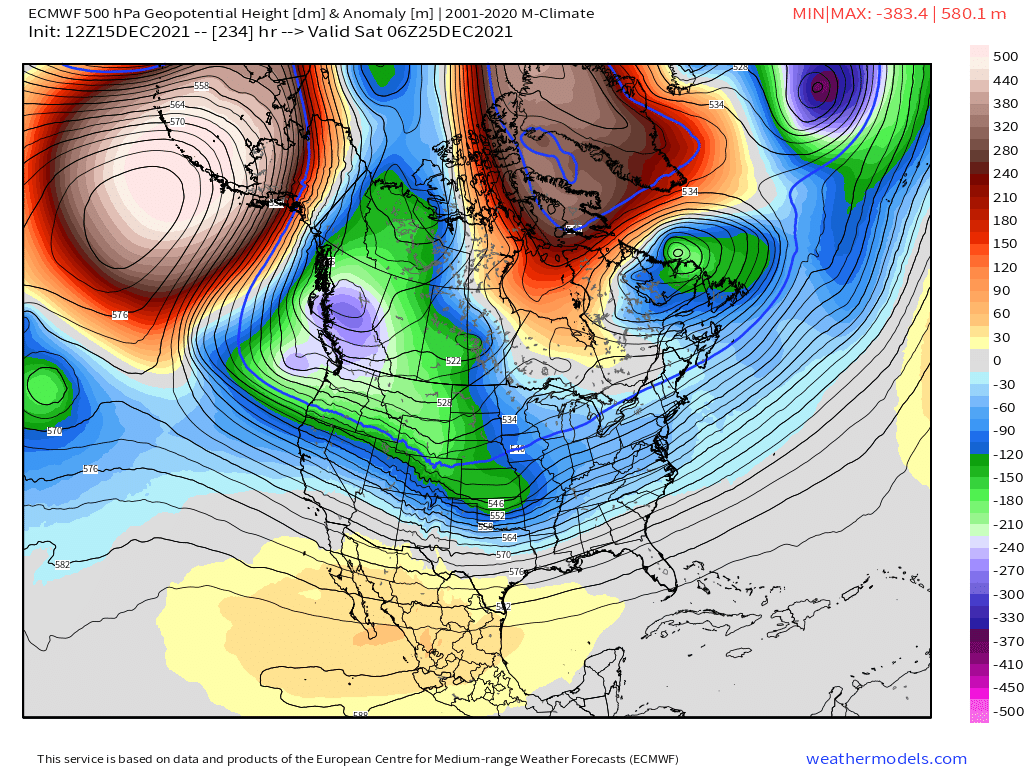
What a monster ridge near Bering sea.....and then a monster -NAO block on the other side of the pole. -
December 2021 Obs/Disco...Dreaming of a White-Weenie Xmas
ORH_wxman replied to 40/70 Benchmark's topic in New England
Still gotta watch the 12/24-12/25 potential -
December 2021 Obs/Disco...Dreaming of a White-Weenie Xmas
ORH_wxman replied to 40/70 Benchmark's topic in New England
This is actually a really good loop....the midlevel center obviously has trended solidly north in the past few runs....but notice how out to the east in the gulf of maine, the 850 temps haven't moved much....which shows the confluence working. The last frame has solid southerly flow at 850 while the first frame was actually out of the north in that area....but yet not a big difference in temps. That's what you want to see for a classic several hour thump. Only limiting factor in the antecedent airmass is pretty crappy....otherwise this would probably be a decent thump down to even near NYC instead of BOS-ORH being near the line. -
December 2021 Obs/Disco...Dreaming of a White-Weenie Xmas
ORH_wxman replied to 40/70 Benchmark's topic in New England
You want a stronger thump to get anything worthwhile....with a marginal profile, a lighter precip shield was going to be pretty useless outside of the interior hills. That's why both the main shortwave and the confluence trending stronger at the same time is a better solution. -
December 2021 Obs/Disco...Dreaming of a White-Weenie Xmas
ORH_wxman replied to 40/70 Benchmark's topic in New England
That's funny that NARCAN is a lot more generous at 00z than you'd expect but less generous down there at 12z. That run looked definitively snowier to me down there than those snow maps would suggest. -
December 2021 Obs/Disco...Dreaming of a White-Weenie Xmas
ORH_wxman replied to 40/70 Benchmark's topic in New England
I'm not sure I follow....below HFD-PVD is less than 00z? 00z had basically nothing south of them....and 12z had several inches. -
December 2021 Obs/Disco...Dreaming of a White-Weenie Xmas
ORH_wxman replied to 40/70 Benchmark's topic in New England
00z had no snow south of HFD-PVD....this run has a few inches down in that zone. -
December 2021 Obs/Disco...Dreaming of a White-Weenie Xmas
ORH_wxman replied to 40/70 Benchmark's topic in New England
No way to know if we get a storm or not in the 12/23-25 timeframe. -
December 2021 Obs/Disco...Dreaming of a White-Weenie Xmas
ORH_wxman replied to 40/70 Benchmark's topic in New England
Yeah it is kind of competing narratives....colder usually means further south with precip, but in this case it does not. The main shortwave is actually stronger than 00z but the confluence to the north is also stronger....so the two trends combined produce a colder outcome but also a more robust precip shield......which is ideal. You want a juiceir shortwave but also not at the expense of cold....the way to get that is to also trend the confluence stronger. -
December 2021 Obs/Disco...Dreaming of a White-Weenie Xmas
ORH_wxman replied to 40/70 Benchmark's topic in New England
Looks definitively colder than 00z....but the precip shield is a bit more robust so it gets NNE better than 00z. -
December 2021 Obs/Disco...Dreaming of a White-Weenie Xmas
ORH_wxman replied to 40/70 Benchmark's topic in New England
Yeah I'm hoping for another tick or two south before the north trend in the final 48-60 hours. This a pretty nice hit for the pike region and northward....but even well down in CT gets advisory snows before it flips to pellets/ZR. -
December 2021 Obs/Disco...Dreaming of a White-Weenie Xmas
ORH_wxman replied to 40/70 Benchmark's topic in New England
Perfect timing for indigestion over Quebec. -
December 2021 Obs/Disco...Dreaming of a White-Weenie Xmas
ORH_wxman replied to 40/70 Benchmark's topic in New England
Yeah this is gonna be cold...starts as snow in almost all of CT. -
December 2021 Obs/Disco...Dreaming of a White-Weenie Xmas
ORH_wxman replied to 40/70 Benchmark's topic in New England
There's a scooter shitstreak in Quebec that is helping shove it south still at 72h. -
December 2021 Obs/Disco...Dreaming of a White-Weenie Xmas
ORH_wxman replied to 40/70 Benchmark's topic in New England
Euro looks like it's getting a bit crunched south at 60 hours compared to 00z 72h....but we'll see for sure in the next few frames. -
December 2021 Obs/Disco...Dreaming of a White-Weenie Xmas
ORH_wxman replied to 40/70 Benchmark's topic in New England
That one had to be at least 1.5-2 inches. Some folks prob got 3"+. -
December 2021 Obs/Disco...Dreaming of a White-Weenie Xmas
ORH_wxman replied to 40/70 Benchmark's topic in New England
Pretty classic running into a brick wall there...you nearly have a closed 850 high sitting there just N of the US/Quebec border. -
December 2021 Obs/Disco...Dreaming of a White-Weenie Xmas
ORH_wxman replied to 40/70 Benchmark's topic in New England
Yeah you need to triple that....you're prob only accreting about 2 tenths of that when you consider both runoff and you lose some to sleet/snow on the front end. -
December 2021 Obs/Disco...Dreaming of a White-Weenie Xmas
ORH_wxman replied to 40/70 Benchmark's topic in New England
We probably need to triple the QPF for him to get his dream of a powerless Xmas. -
December 2021 Obs/Disco...Dreaming of a White-Weenie Xmas
ORH_wxman replied to 40/70 Benchmark's topic in New England
I can't take the swings on that model. It's infuriating. But I guess it nails the H5 pattern over the Galapagos Islands so we should treat it with respect. -
December 2021 Obs/Disco...Dreaming of a White-Weenie Xmas
ORH_wxman replied to 40/70 Benchmark's topic in New England
Ukie is coming in a lot colder too, but that model had parrots flying into ORH last night, so it's no surprise it's backing off after what we've seen already at 12z. -
December 2021 Obs/Disco...Dreaming of a White-Weenie Xmas
ORH_wxman replied to 40/70 Benchmark's topic in New England
Yeah it is typical in these events where the WAA aloft is stronger off to the west as opposed to a coastal that might be hugging the coast where the WAA is strongest in southeast areas. -
December 2021 Obs/Disco...Dreaming of a White-Weenie Xmas
ORH_wxman replied to 40/70 Benchmark's topic in New England
GGEM actually has the back-end snow that Scooter and I were discussing a while ago. Tries to pop a little conveyor as it exits and flips most of the region to snow (that wasn't already previously) for several hours. -
December 2021 Obs/Disco...Dreaming of a White-Weenie Xmas
ORH_wxman replied to 40/70 Benchmark's topic in New England
There's a crazy gradient for this thing to feed off of too....you have like +13C 850 temps down near DC while it's -5C to -10C from northern SNE into NNE.