ORH_wxman
-
Posts
90,902 -
Joined
-
Last visited
Content Type
Profiles
Blogs
Forums
American Weather
Media Demo
Store
Gallery
Everything posted by ORH_wxman
-
December 2021 Obs/Disco...Dreaming of a White-Weenie Xmas
ORH_wxman replied to 40/70 Benchmark's topic in New England
Miracle on Scooter Lane? -
December 2021 Obs/Disco...Dreaming of a White-Weenie Xmas
ORH_wxman replied to 40/70 Benchmark's topic in New England
Scooter white Christmas saved on 18z gfs. -
ICON tickled colder at 18z if we even give a sh*t about that model....it was one of the warmer ones at 12z though....so we're seeing some convergence now (RGEM coming in warmer after being one of the coldest models too).
-
RGEM looks like it's tickling warmer on the 18z run. It was pretty cold at 12z with like 3-4" down into central CT....this run is giving the advisory snows mostly along and north of the MA/CT border.
-
December 2021 Obs/Disco...Dreaming of a White-Weenie Xmas
ORH_wxman replied to 40/70 Benchmark's topic in New England
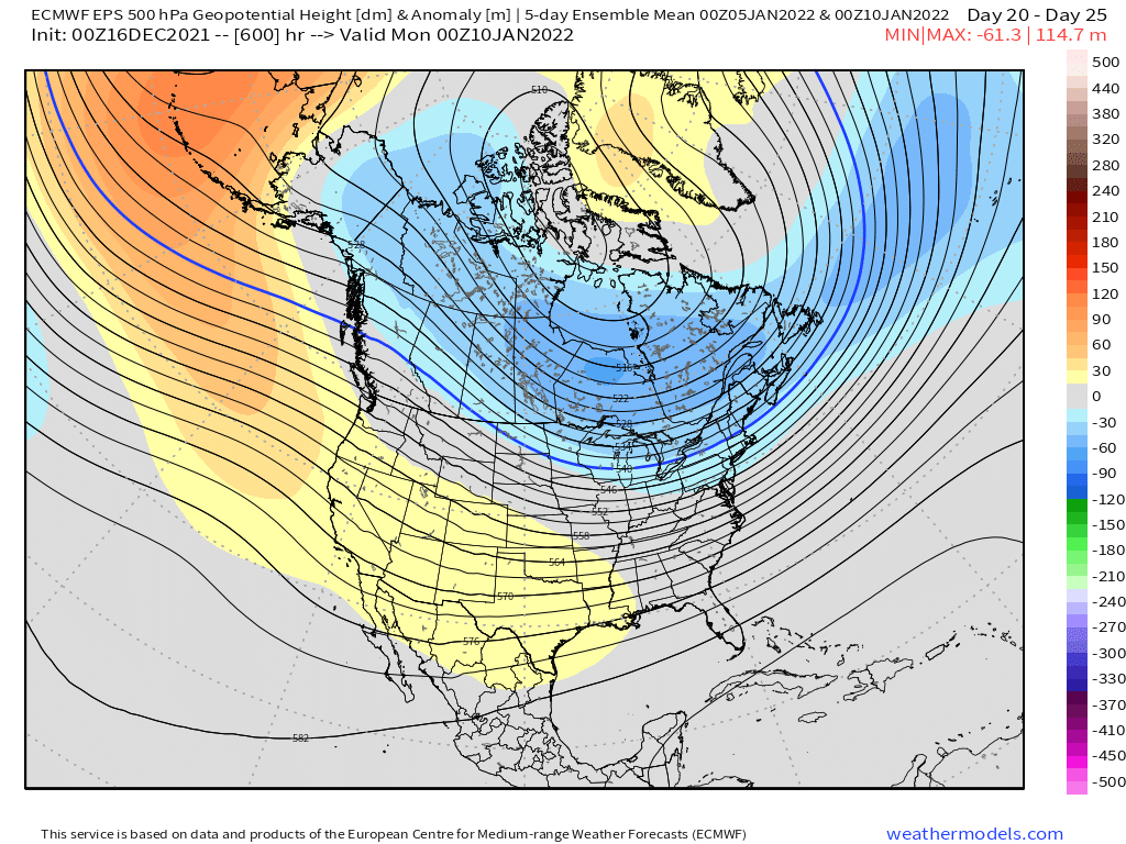
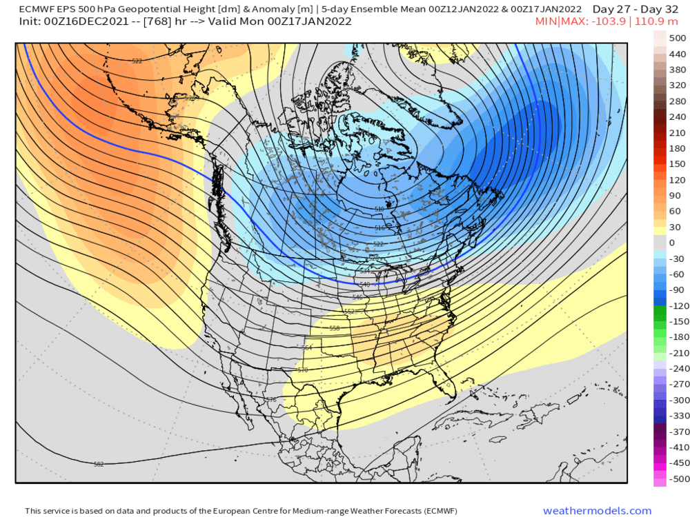
Weeklies are pretty nice....they shift the PAC/Aleutian ridge eastward in January so it's more over the GOA and EPO region...so we lose the deeply negative PNA trough. Here's the 5 day mean Jan 10th and then the same thing for Jan 17th...note how the ridge moves eastward. This is getting pretty far out there but that would be a good time for that to happen as they start to lose the NAO blocking
-
3km NAM was actually decently colder than the 12km on the 18z run.
-
December 2021 Obs/Disco...Dreaming of a White-Weenie Xmas
ORH_wxman replied to 40/70 Benchmark's topic in New England
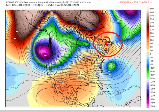
Here's a visual of the 12z OP run and the EPS....notice how on the EPS, you see the PV lobe anomaly pinned underneath the NAO block up in the Maritimes/New Foundland but on the OP, it's nada.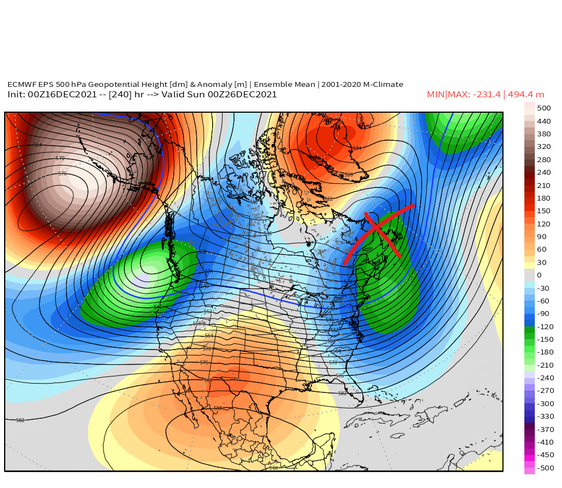
-
December 2021 Obs/Disco...Dreaming of a White-Weenie Xmas
ORH_wxman replied to 40/70 Benchmark's topic in New England
OP euro solution is kind of ugly in that the southern stream gets totally isolated and cutoff but the fact there is a storm there is good to see. Even with those flaws, it's pretty close to a good event. One of the flaws on this run is that a chunk of the PV that was previously getting pinned under the NAO block actually retrogrades back west into the PNA domain, which gives us a worse airmass to work with too. -
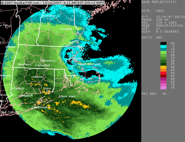
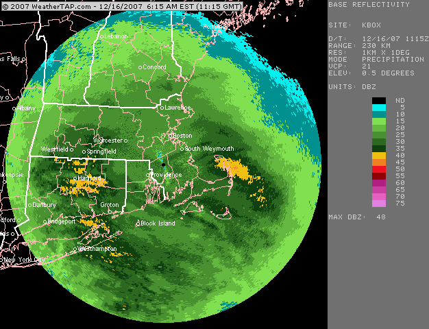
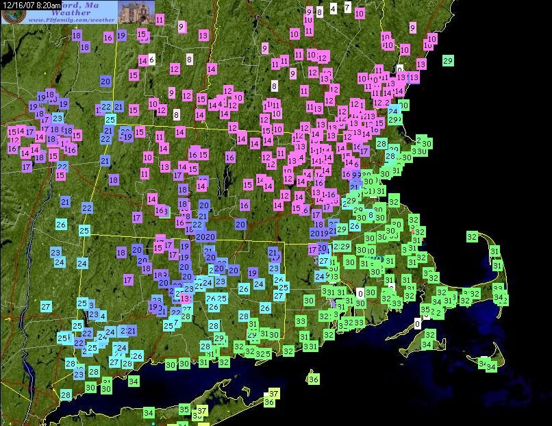
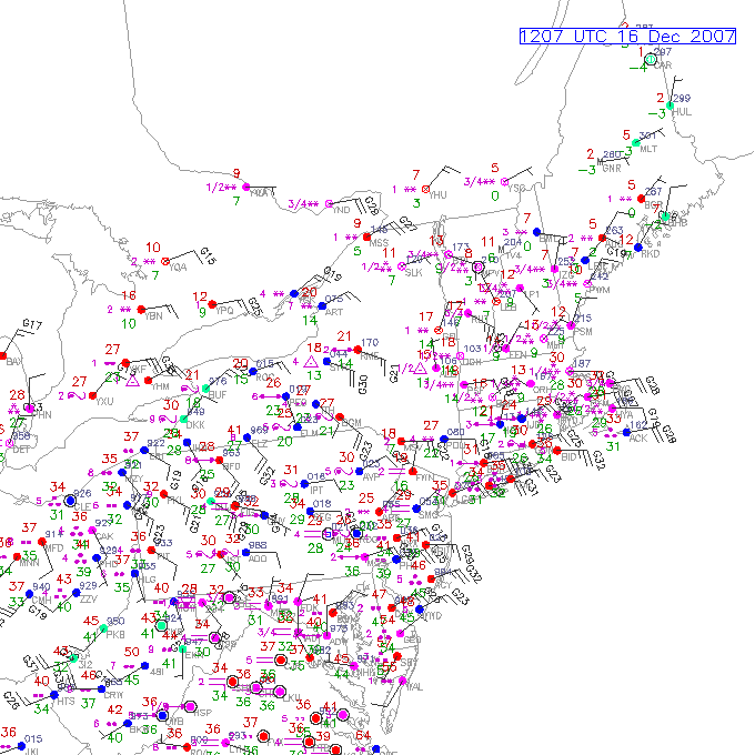
Nice write up 4seasons....that band up in NY and into VT?NH was one of the most ridiculous mesobands I've ever tracked. Not to be forgotten either is the anniversary of the 12/16/07 bust....mostly 2-4" amounts were forecast for SNE...and while that was fairly accurate down in southern parts...much of MA/N RI busted way positive....with 6-10" for a large area. While we didn't have dual pol CC back then, we could still see the yellows washing out near the southern MA border....this was very heavy snow too with good dendritic growth....2" per hour stuff. First image is just after 5am....and then the second image is 2 hours later....not a lot of headway made on the sleet line. Then that storm also had a crazy tight coastal front...and finally my favorite image is the sfc plot that shows sleet up in upsate NY while it's ripping snow on the Cape.
-
Doubt it...dryslot punches in pretty hard from the WSW. Might get a few flurries on the back end, but nothing meaningful unless this trended further south.
-
You've been pretty consistently in the 3-5/4-6 zone on almost every run save for a couple scaryish torch runs. I wouldn't be sweating there too much regardless. Worst case scenario for you is prob like 2" with several hours of scalping BBs....more likely you'll prob get a good high end advisory thump Also, the snow maps are more sensitive in ORH county because the sfc temps there are cold...so any run where the warm layer aloft is colder/warmer will affect the totals more. Your area is prob getting a slight penalty on various clown maps for sfc temps near or just above freezing (I'll take the under...you'll prob be a couple ticks below freezing in reality)....so even a "Colder" run aloft, doesn't help you as much as it should.
-
I'd sign on the dotted line if I could make this run verify...I'd take 3-4" with some IP/ZR in there and run. Need another tick colder though before we get those NAM runs 30 hours out that have the chickens getting pelted with BBs.
-
Tauntonblizz sucked back in on this run...pretty decent for SE MA on the front end.
-
12z Euro a tick colder than the 00z run through 54h. (didn't compare to 06z)
-
December 2021 Obs/Disco...Dreaming of a White-Weenie Xmas
ORH_wxman replied to 40/70 Benchmark's topic in New England
12z GFS is a good example of that NAO block doing a lot of dirty work. Notice how every system that makes an attempt to go west of us gets crunched underneath. -
12z Ukie a tick colder as well.
-
We'll wait for when the correlation coefficient shows the sleet line rotting for several hours somewhere near Union CT before we dig that one up.
-
Yeah it brings maybe low end advisory snows down to MA/CT border or even into Kevin's hood in N CT....whereas the 00z run was more pike region and north.
-
There's a reason he's the best insurance salesman east of the Mississippi.
-
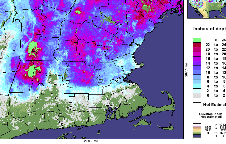
That is still an unbelievable snow depth map....lol. That was a couple days after the dual part MLK event in 2010.
-
Maybe we'll end up with a snowpack that looks like this
-
GFS coming in a tick colder too.
-
2010 MLK gradient
-
December 2021 Obs/Disco...Dreaming of a White-Weenie Xmas
ORH_wxman replied to 40/70 Benchmark's topic in New England
People need to think of patterns in terms of probabilities or chances. For example, lets say in a really average/medicore pattern we have a 2 in 8 shot of getting a solid snow event in any given 10 day period. In a garbage pattern its maybe 0 or 1 in 8. In an epic pattern, maybe we have a 6 in 8 shot. In a pretty good pattern, maybe it's 4 or 5 in 8. The point is, you "load the dice" from the baseline probability in a pattern that deviates from the baseline. So in a shitty pattern, you load the dice against you, in a good pattern, you start loading the dice in your favor. There are no guarantees, but you will gladly play the game with loaded dice in your favor since eventually, the law of large numbers will work out in your favor. Same thing applies when looking at patterns. I know it's just easier to demand a binary answer on whether big snows are coming or not....but hopefully the above helps visualize the probability angle a little better. -
December 2021 Obs/Disco...Dreaming of a White-Weenie Xmas
ORH_wxman replied to 40/70 Benchmark's topic in New England
Huge coastals aren't typical in this pattern....they can happen, but more likely you;ll get SWFE and redevelopers and overrunning events. The NAO block is very important in this type of pattern because without it, cutters have an easier time getting west of us rather than being forced underneath. You can still get cutters in this pattern, but it's just harder....you need a solid phasing event.