ORH_wxman
-
Posts
90,902 -
Joined
-
Last visited
Content Type
Profiles
Blogs
Forums
American Weather
Media Demo
Store
Gallery
Everything posted by ORH_wxman
-
Definitely lost the to GFS in the 96-120 timeframe....so a bad showing by the Euro. Confidence not restored after its win last week.
-
Yeah it was better for everyone N of rt 2....it wasn't much difference here, but it trimmed the 1-2" amounts down in CT/RI
-
The WAA has a harder time the further east you get....this isn't like a usual coastal.
-
Euroi ticked warmer again....pretty big juice-up in QPF though...so that's gonna be better for those who can stay snow long enough to take advantage.
-
December 2021 Obs/Disco...Dreaming of a White-Weenie Xmas
ORH_wxman replied to 40/70 Benchmark's topic in New England
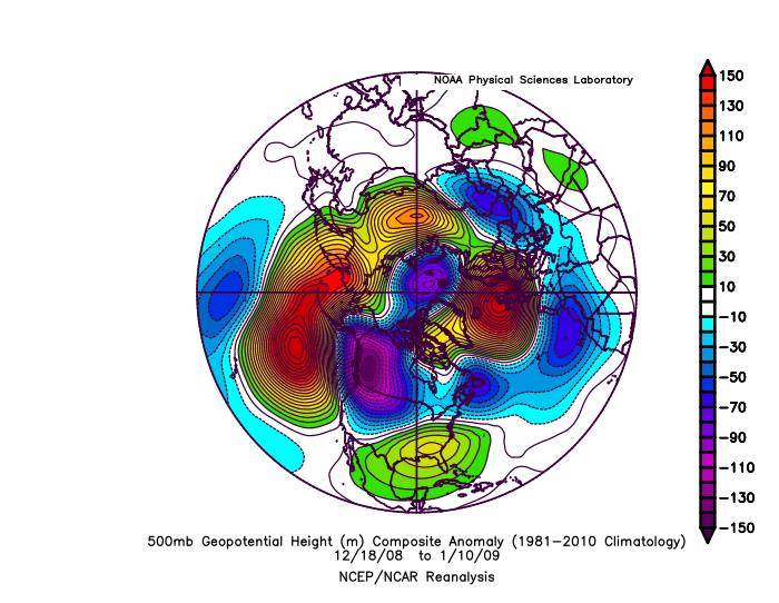
And here;s another....one that didn;t work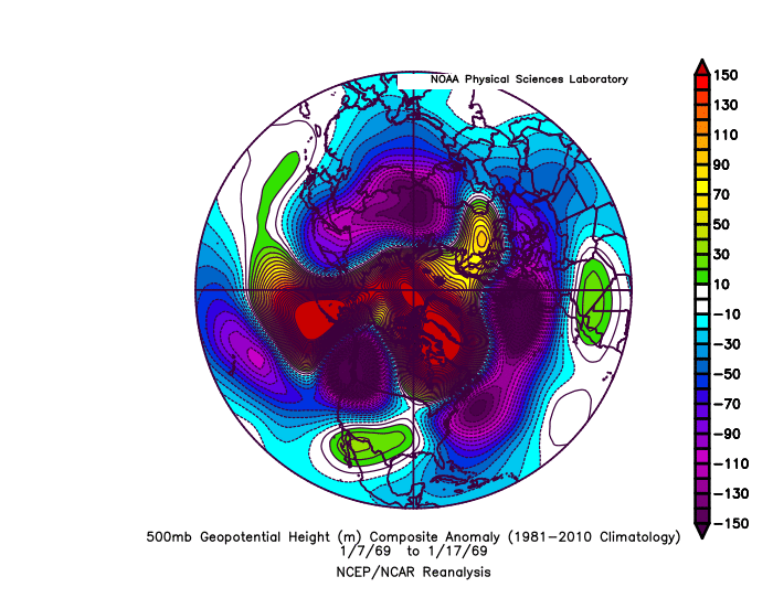
-
December 2021 Obs/Disco...Dreaming of a White-Weenie Xmas
ORH_wxman replied to 40/70 Benchmark's topic in New England
Here's a couple similar patterns: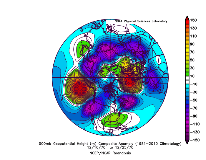
-
December 2021 Obs/Disco...Dreaming of a White-Weenie Xmas
ORH_wxman replied to 40/70 Benchmark's topic in New England
Canadian tries to redevelop a clipper on Xmas even to our south....that would prob be enough for white Xmas for most of us. These types of embedded shortwaves in the fast flow are going to be hard for models to resolve at this lead time. The pattern definitely gets even better after Xmas, but I wouldn't sleep on the 12/24-12/25 potential yet. -
December 2021 Obs/Disco...Dreaming of a White-Weenie Xmas
ORH_wxman replied to 40/70 Benchmark's topic in New England
Yeah I'm more interested in the train of shortwaves between 12/24-12/27. I'm hoping one of the early ones can deliver for Xmas, but I'll take any of them delivering. -
December 2021 Obs/Disco...Dreaming of a White-Weenie Xmas
ORH_wxman replied to 40/70 Benchmark's topic in New England
We're gonna have Tblizz listening to White Snake before too long while he watches the models whiff us one after the other. -
Yeah the higher end SWFEs usually have a nice high north of Maine that is holding in an already advected-in cold antecedent airmass. In this one, the cold is kind of leaking in at the same time the event tries to start and you don't quite have that really good ML fronto that causes the storm to come in like a wall. There is definitely some good confluence, but it is not oriented great for the classic warning event SWFE and in this case, prob not even advisory until you are north of Rt 2.
-
December 2021 Obs/Disco...Dreaming of a White-Weenie Xmas
ORH_wxman replied to 40/70 Benchmark's topic in New England
GFS has the PV lobe really strong. If you got a compromise with the Euro here, you might grab a nice event on Xmas.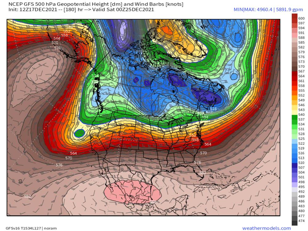
-
Yeah I'm selling advisory snow here....I'd prob go C-2" for pike region. I'd consider 2" a pretty solid win for this event.
-
It's frigid at 850 but the NAM has that warm nose at 750mb......looks like a scalping here.
-
Yeah the precip shield looks pretty cruddy when it's cold enough for snow...and it may never snow south of HFD. You'll prob start as some snow....it would be the type of thing where the cruddy precip shield has you starting as sleet, and then it goes over to snow as the better lift moves in and then back to sleet as the warm layer intrudes. But yeah the dynamics look pretty weak sauce, so I'm not expecting more than a couple inches here...I'd consider a couple inches a win actually. It wouldn't be shocking if its like 0.5-1" or something and then sleet crud for hours.
-
That one was like over OH Valley/W PA and it eventually sliced over New England....it was almost a coastal but further west.
-
December 2021 Obs/Disco...Dreaming of a White-Weenie Xmas
ORH_wxman replied to 40/70 Benchmark's topic in New England
There's a couple chances....the longer shot is 12/22-23....but there's a distinct chance at something 12/24-25 too....some guidance kind of has it more like 12/26....but there's a lot of shortwaves in the flow. The key is getting the -NAO to pin enough of a 50/50 low to force any potential cutters to our south. I also expect additional chances in the week to 10 days post-Xmas. You have that big -PNA just firehosing the flow with shortwaves into the NAO block. -
You never want to see the vortmax kind of sheared and tracking through Ottawa and Montreal for a big front end thump....you typically want that more consolidated and closer to us.
-
This also doesn't come in like a wall of S+ like some other SWFE...this is probably going to be putrid 1 mile type SN- with garbage flakes for the first 4-6 hours...it really doesn't start getting going until mid-event which by then, the scalping will be pretty far north.
-
December 2021 Obs/Disco...Dreaming of a White-Weenie Xmas
ORH_wxman replied to 40/70 Benchmark's topic in New England
EPS is actually grazing us with some light snow for next week’s 12/22-23 system. We’ll have to keep an eye on that one. -
Yeah it’s unlikely to be a huge issue. If we were getting double or triple the QPF it would be more interesting. Hopefully guidance cools a tick today because ZR is pretty useless. But I’m guessing the midlevel warming trend will actually continue at 12z. I’m just hoping for a couple inches here before the flip but it’s looking precarious.
-
There won’t be a lot of glazing in this event. Of course, it doesn’t take much to be dangerous, but I’d be surprised if any glaze was more than a couple tenths. Not a classic look for big ice.
-
Rgem looked a little cooler than 18z. edit: Bristol beat me to it
-
December 2021 Obs/Disco...Dreaming of a White-Weenie Xmas
ORH_wxman replied to 40/70 Benchmark's topic in New England
We need mainejayhawk to make a gif of George Bailey running through downtown in the snow and photoshop a scooter head on it. -
18z euro ticked warmer. Took CT out of the advisory snows except maybe far N CT.