

ORH_wxman
-
Posts
90,902 -
Joined
-
Last visited
Content Type
Profiles
Blogs
Forums
American Weather
Media Demo
Store
Gallery
Everything posted by ORH_wxman
-
December 2021 Obs/Disco...Dreaming of a White-Weenie Xmas
ORH_wxman replied to 40/70 Benchmark's topic in New England
Euro is weak sauce and north with the Xmas eve shortwave...maybe a dusting for some folks in NNE. -
December 2021 Obs/Disco...Dreaming of a White-Weenie Xmas
ORH_wxman replied to 40/70 Benchmark's topic in New England
Not gonna happen...airmass is trash anyway....when I-95 in Maine is flirting with the R/S line, it's garbage. -
December 2021 Obs/Disco...Dreaming of a White-Weenie Xmas
ORH_wxman replied to 40/70 Benchmark's topic in New England
I think down here it's really two...not seeing how we get much, if any, snow from 12/22 in SNE...maybe N ORH county could. It's really going to come down to 12/24 or 12/25. -
December 2021 Obs/Disco...Dreaming of a White-Weenie Xmas
ORH_wxman replied to 40/70 Benchmark's topic in New England
The further west solutions on 12/22 seem to have further south solutions on 12/25...while the further east 12/22 solutions are more north/warm for 12/25 due to the 12/22 system not phasing as much and hence, the block and 50/50 low is a little weaker. -
December 2021 Obs/Disco...Dreaming of a White-Weenie Xmas
ORH_wxman replied to 40/70 Benchmark's topic in New England
There's going to be a lot of model volatility I think over the next 24-36 hours because some of the key features for 12/24 and 12/25 aren't onshore yet...and 12/25 is especially poor because satellite-derived data gets more unreliable in the arctic with the very low tropopause.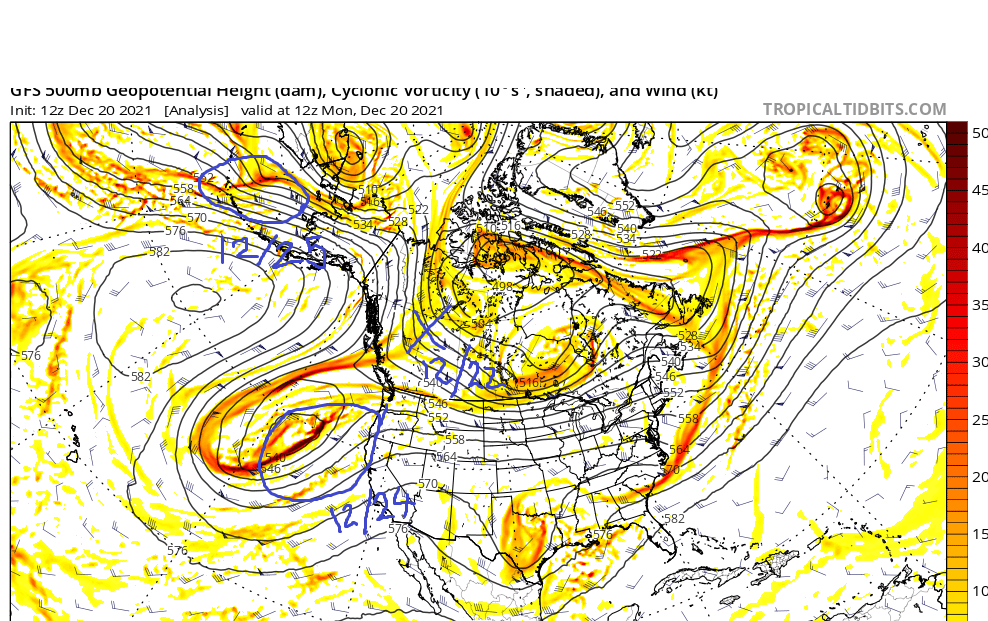
-
December 2021 Obs/Disco...Dreaming of a White-Weenie Xmas
ORH_wxman replied to 40/70 Benchmark's topic in New England
GGEM has the Xmas eve snow too but it's a little further north in MA/S NH and a little drier than the GFS. CT gets a nice little hit Xmas morning on the GGEM. -
December 2021 Obs/Disco...Dreaming of a White-Weenie Xmas
ORH_wxman replied to 40/70 Benchmark's topic in New England
Yeah probably...depends on the low track but on the GFS it would. Prob highs in the low to mid 30s. -
December 2021 Obs/Disco...Dreaming of a White-Weenie Xmas
ORH_wxman replied to 40/70 Benchmark's topic in New England
1-2" on Xmas eve if GFS is right...hopefully that comes through. -
December 2021 Obs/Disco...Dreaming of a White-Weenie Xmas
ORH_wxman replied to 40/70 Benchmark's topic in New England
Yeah agreed...i don;t love the deep western trouhg, but even years like 1970 had a REALLY deep -PNA and it still worked. So much of it is nuance though. At least it's way better than a one eyed pig over AK. -
December 2021 Obs/Disco...Dreaming of a White-Weenie Xmas
ORH_wxman replied to 40/70 Benchmark's topic in New England
My guess is mid-week still mostly misses east even though the NAM got precip in here. If that phase had happened much further south, then we would've developed a CCB sooner and you prob would get good interior snows from that track....but when the thing is just trying to phase almost as it reaches you, that's one of the warmest sequences in the storm evolution. -
December 2021 Obs/Disco...Dreaming of a White-Weenie Xmas
ORH_wxman replied to 40/70 Benchmark's topic in New England
-PNA/-NAO can be a high stakes pattern....you can get strong gradients. We talk about great stretches like December 1970, but you go south a bit and there was almost nothing...but on the north side of the mean boundary, it was prolific snows. The NAO migrating west makes me think that over time, the gradients will be pressing south...it starts out kind of north, and then sinks. Going deeper into climo winter will also help as well. -
December 2021 Obs/Disco...Dreaming of a White-Weenie Xmas
ORH_wxman replied to 40/70 Benchmark's topic in New England
Or press it south 50-100 miles and it's pretty fun the whole time...some of the other guidance has that. -
December 2021 Obs/Disco...Dreaming of a White-Weenie Xmas
ORH_wxman replied to 40/70 Benchmark's topic in New England
Having a primary low up in lake huron is pretty useless. -
December 2021 Obs/Disco...Dreaming of a White-Weenie Xmas
ORH_wxman replied to 40/70 Benchmark's topic in New England
I've said it before and I'll say it again....many of our most prolific stretches have come during -PNA/-NAO patterns. -
December 2021 Obs/Disco...Dreaming of a White-Weenie Xmas
ORH_wxman replied to 40/70 Benchmark's topic in New England
There’s a leading shortwave we need to watch for 12/24...could bring a round of light snow...then the main wave on 12/25. Both systems are kind of all over the place on model guidance...euro doesn’t really have much on 12/24 and then looks pretty torchy for 12/25...meanwhile other guidance has both distinct waves and is much colder. -
December 2021 Obs/Disco...Dreaming of a White-Weenie Xmas
ORH_wxman replied to 40/70 Benchmark's topic in New England
You coastal guys are due for a few more disaster systems. We’ll chew on 12/26/12 and 12/29/12 while you wait for the PNA to get better. -
December 2021 Obs/Disco...Dreaming of a White-Weenie Xmas
ORH_wxman replied to 40/70 Benchmark's topic in New England
We actually saw the NAO kind of merge with higher heights in the east in December 2012 for a time. -
December 2021 Obs/Disco...Dreaming of a White-Weenie Xmas
ORH_wxman replied to 40/70 Benchmark's topic in New England
That’s definitely a possibility but it doesn’t happen very often. You usually need a big phasing event. -
December 2021 Obs/Disco...Dreaming of a White-Weenie Xmas
ORH_wxman replied to 40/70 Benchmark's topic in New England
He posted a delta map. Not anomaly map. It was an intentionally deceptive post to generate a response. -
Yes. There was a massive cutter Xmas Eve.
-
NWS Taunton had a snow depth of 8 inches on Xmas. Depth of 7 inches on 12/26. 4 inches on 12/27...then wiped out by 12/28. I double checked further south too at east wareham coop and they had very similar numbers.
-
There’s no way it was wiped clean Xmas morning there. The torch storm didn’t happen until the 27th.
-
December 2021 Obs/Disco...Dreaming of a White-Weenie Xmas
ORH_wxman replied to 40/70 Benchmark's topic in New England
Euro actually has some decent front end snows for outside 128 predawn Xmas morning. -
December 2021 Obs/Disco...Dreaming of a White-Weenie Xmas
ORH_wxman replied to 40/70 Benchmark's topic in New England
Yeah the Canadian would work. That storm is likely to get squashed south of the block, the question is exactly how far south and that makes all the difference. -
December 2021 Obs/Disco...Dreaming of a White-Weenie Xmas
ORH_wxman replied to 40/70 Benchmark's topic in New England
I dunno. Pre-Xmas was always precarious even if still possible. It’s not like guidance is pushing back the blocking. If anything, guidance has improved since a week ago....remember when the SE ridge was poking into SNE on all the longer range guidance about a week ago? You don’t see that now.


