ORH_wxman
-
Posts
90,902 -
Joined
-
Last visited
Content Type
Profiles
Blogs
Forums
American Weather
Media Demo
Store
Gallery
Everything posted by ORH_wxman
-
Your small area in NE MA has been a bit of a screwgie the past 3 winters but not indicative of the region as a whole. A good chunk of SNE did fine last year.
-
12/17/08 was a weak overrunning event that dropped an inch or two of snow and then a small glaze. It wasn’t a significant event. A couple days later we got a big snow event on 12/19/08.
-
A solid dose of crappy snow winters is needed IMHO. The 2000s/2010s turned us into entitled whiners.
-
We need another 495 paste bomb like last year to set some of the weenies over the cliff. Plenty of teetering right now.
-
Those are solid snow banks in your pics. The advantage of having lots of mixed crap in the snow is that you really solidify the pack and it also makes the snow banks look huge. I’ve had snow/sleet events of 4 inches that have bigger snow banks and piles than a 10-12 inch fluff bomb. Now that you have the glacier, just need the powder events on top.
-
It’s a little bit frustrating because while the pattern has kind of been crappy, it’s been nothing like other years with similar results. This type of snowless start to the season happens roughly once per decade in ORH. Last instances going into New Years this low were 2015, 2006, and 1999. Those years were just CONUS-wide chinook torches that never had anyone expecting snow. But this year has at least had some semblance of a few chances even if facing some headwinds. But still mostly skunked.
-
ORH sitting below 5” for the season on 12/26 isn’t within the 1 SD envelope either. Cruddy pattern and a little bit of crap luck on top of it. Could’ve scored something a little bigger (even if advisory) in either early December or more recently after 12/17 but it hasn’t happened.
-
Garbage decade. I think only the 1930s was worse. Median was 56.3 and mean is about 58”. Only 2 above average. Even the 1980s had 4 above average winters (3 if we count 87-88 as average since it was barely above avg).
-
The only generation that really has credence in saying that are those who had most of their childhood from the late 1950s through early 1970s. That was a pretty awesome stretch. The modern version of that will be those who grew up mostly between 2000-2015. The difference is that there were a couple awful ratters mixed in but they also had some really high end winters that even the 1960s had trouble matching like 2014-2015…and the ridiculous storms too. Really high end KU type events.
-
The 1930s through the early 1950s were pretty much dogshit for BOS snow (and most of New England)…there were a few good years in there like 1947-48…but the bad ones vastly outweighed them.
-
Yeah that looks like a paste job.
-
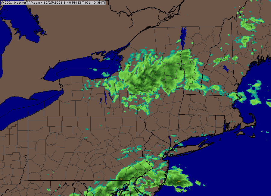
HRRR has been moving the snow south a bit each run too.
-
3k NAM actually gets a couple inches into BOS.
-
It’s out in NY state
-
Prob still relevant for December thread but 12/29 still may end up interesting.
-
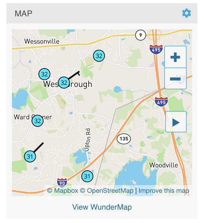
Most likely. I see some 31s mixed in with the 32s there in westborough.
-
Yeah I wonder if ray and SE NH grabs 2-4” overnight.
-
Gonna have to watch for a flip to a quick burst of snow overnight in E MA. Esp up in NE MA but it could get into BOS and metrowest. Euro has like 1-2”.
-
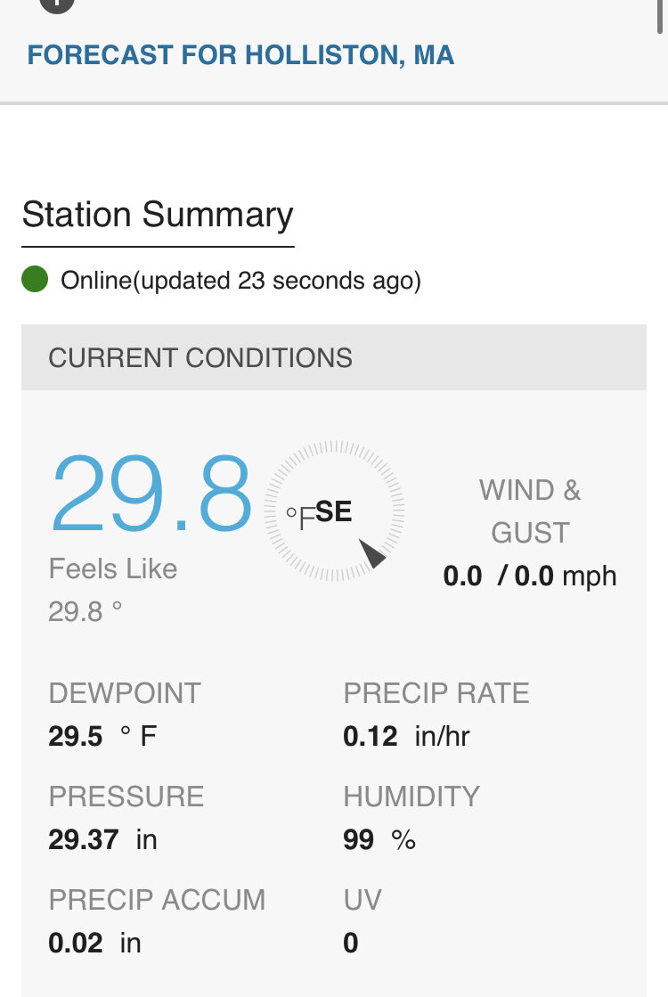
Logan finally above freezing now. 33F. Pretty impressive to have that ZR right into the city.
-
The warmest layer on a lot of soundings was pretty low. Like below 900mb. Kind of a weird event where the warm layer was so low, yet the sfc temps were pretty darned cold. Usually it’s the other way around.
-
Prob getting pretty saggy back home
-
It’s also pretty warm just barely aloft. I made a post last night on how warm it was at 925-950mb. So that will also limit the efficiency of the accretion. It’s still really nasty though driving on side roads. But the lesser efficiency should help keep the accretion lower on the trees and power lines.
-
Merry Christmas weenies. What a nasty ZR event unfolding early This morning. Even into BOS….AWT. Mid 20s over ORH county. We’ll see how fast that warms.
-
Yeah this is a good cliff’s notes version explanation of the balancing act that needs to occur. I’ve seen so many potential larger ice events become more just nuisance because of too many ice pellets or latent warming to near freezing. Ironically several months before the December 2008 storm, we narrowly avoided a monster ice event on Feb 12-13, 2008. We had pretty solid accretion but it kind of stalled out around a quarter to 3/8ths and then we rotted near 32F with very heavy precip rates and most of it ran off. We just didn’t quite have the dewpoint drain there. Little did I know that it would all materialize 10 months later almost to the day.
-
I always felt anecdotally in “calm wind” ice events, I ended up at 32.1F pretty damned fast even when starting out cold. It’s nice that subsequent research ends up proving that to be at least a little more than just anecdotes. Also, even back a recently as the 1990s, there was conventional wisdom that the valleys would always be the worst icing spots. I remember reading so many forecasts and AFDs about the CT valley having to watch out for the ice and then I would be 29F and FZRA while CEF and BDL were 34F and RA. It was occasionally true they would get ice while we rained but usually in southerly flow events with in-situ CAD where the icing wasn’t a big deal anyway and would fairly quickly change to rain there…the more serious events were always worse with elevation (at least below a couple thousand feet)…it seemed like the ice climo knowledge was imported from outside New England in many of those instances.