ORH_wxman
-
Posts
90,902 -
Joined
-
Last visited
Content Type
Profiles
Blogs
Forums
American Weather
Media Demo
Store
Gallery
Everything posted by ORH_wxman
-
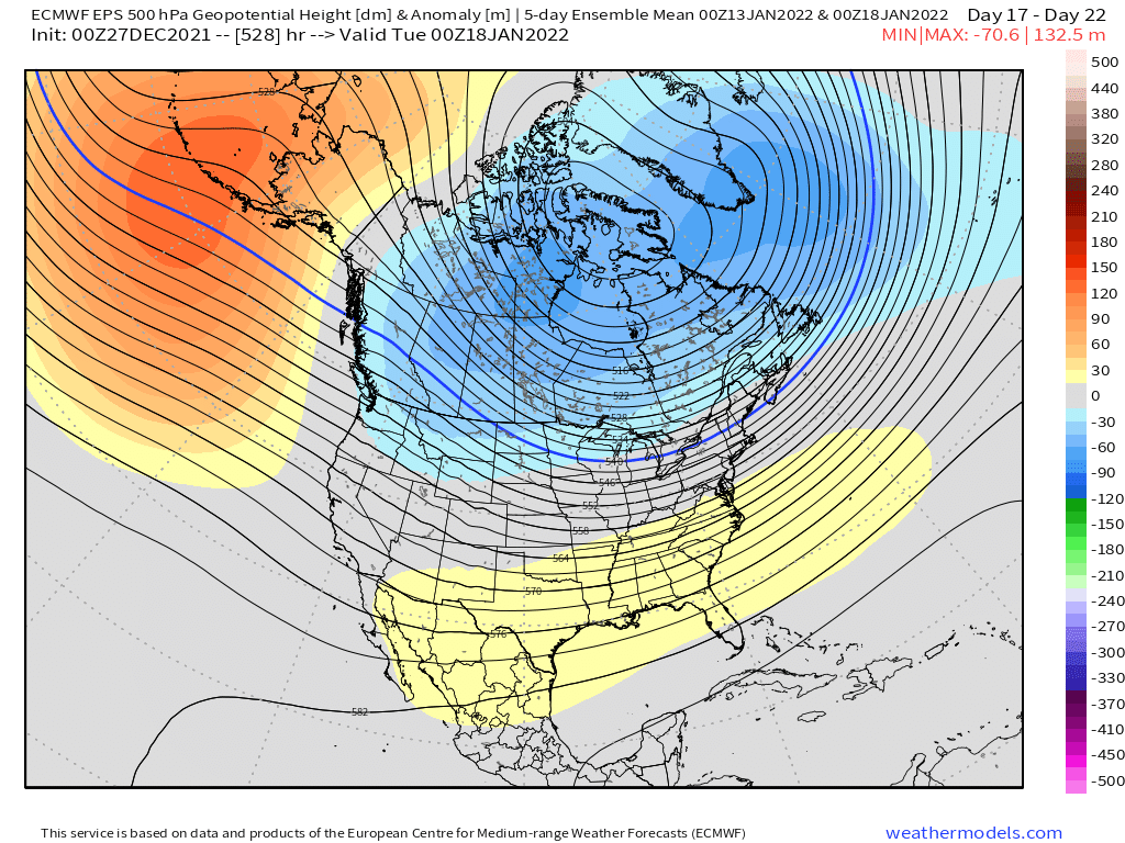
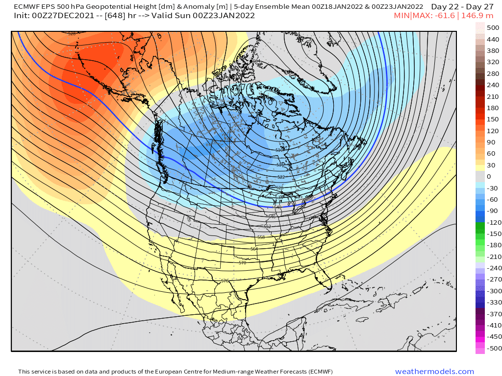
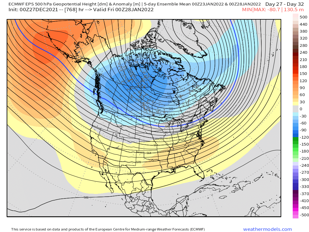
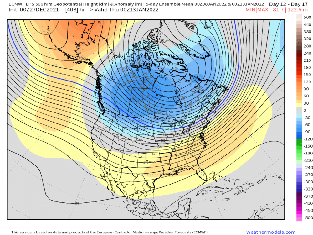
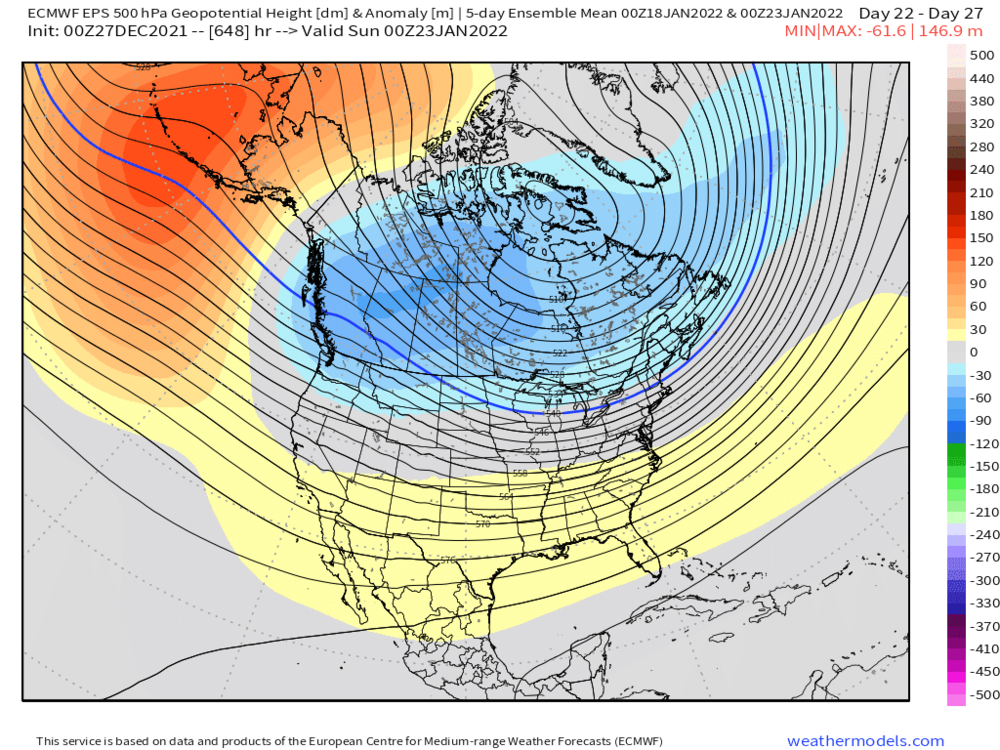
EPS actually pops a positive PNA (or close enough in terms of sensible wx pattern) in the 11-15….not buying it yet but that would be a welcome change. Esp since the NAO blocking is going away.
-
Euro is going full on Rainer into southern Canada. But where you are, I’d definitely still watch it for a colder solution in the next few days. We’re prob toast down here.
-
The 3rd low looks a bit like a fraud….maybe it’ll work out but imho the best chance is to trend the one before it into a classic overrunning/SWFE.
-
Alright enough of the bickering…I just deleted a bunch of junk.
-
The deeper PNA trough also caused the more amplified ridge into the south-central US (like TX/OK up into the lower MS valley) and that helped shred systems…if a few of these shortwaves stay slightly less shredded, you prob get a couple of warning events out of it.
-
Yeah the best match for the pattern in the second half of this month was Dec 1970….but nuances such as a slightly deeper PNA trough out west make a big difference. You can tell though just by looking at the pattern how it wouldn’t have taken much of a tweak to get a bunch of solid events.
-
Annual tradition around here…canceling winter in December. We’ve even had people doing it when December was decent (like last year)…lol.
-
Guidance could change too. It’s assuming we get a big cutter in there and that doesn’t always happen…esp in strong -WPO/EPO block that is going right into the North Pole…you can sometimes end up CADing the system. I know everyone is assuming the warm trend wins out because we’ve been getting mostly skunked but just as often you may see a trend of lowering heights in Quebec too.
-
December 2021 Obs/Disco...Dreaming of a White-Weenie Xmas
ORH_wxman replied to 40/70 Benchmark's topic in New England
Funny how their previous record December snowfall there in Tahoe was December 1970. Too bad we didn’t get that month back here. -
That blizzard comment was just for him.
-
Yep. Maybe we can get a nice period like Jan 94 or late Dec 08 through mid Jan 09. Can get some Miller Bs in that pattern too but a little harder…nobody should have visions of monster blizzards dancing in their head.
-
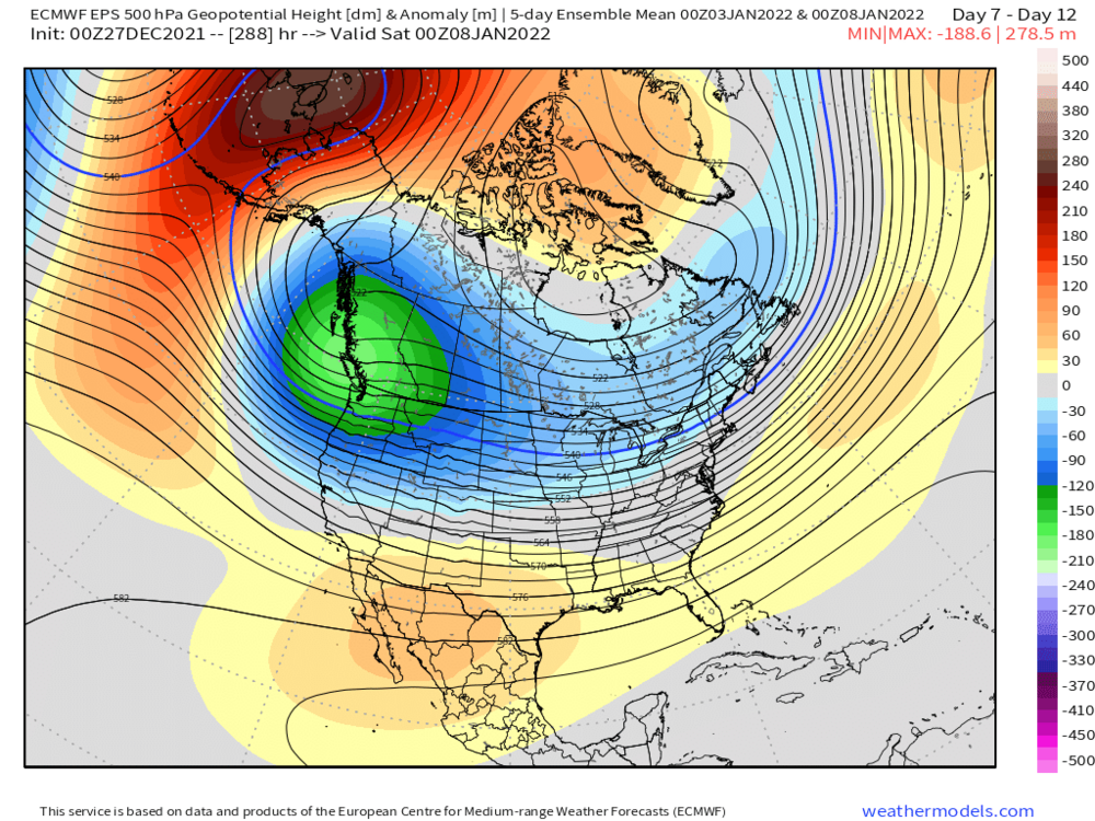
They’ve done pretty well in the arctic but they definitely underestimated the PNA trough out west.
-
I think it looks quite good. Obviously we need it to verify…but I’m totally fine with that pattern. Big ridging in the Bering strait with weak SE ridging is actually pretty classic for active/snowy pattern in New England. It is cold too.
-
Here’s the progression…this is still pretty classic La Niña but at least we’re not digging the trough into palm trees down in Cabo San Lucas


-
Weeklies are pretty chilly for January. Hopefully we can start playing catch-up in the snow department.
-
December 2021 Obs/Disco...Dreaming of a White-Weenie Xmas
ORH_wxman replied to 40/70 Benchmark's topic in New England
ORH had about an inch of snow/ice OTG until yesterday. -
December 2021 Obs/Disco...Dreaming of a White-Weenie Xmas
ORH_wxman replied to 40/70 Benchmark's topic in New England
It’s prob fairly close but I’ll bet “pit2” averages a bit more. But they can get skunked sometimes being right on the water in the wrong type of pattern…that’s why it’s close to begin with and once you go a few miles inland in Maine it increases rapidly….in a latitude gradient pattern they will do much better regardless. -
December 2021 Obs/Disco...Dreaming of a White-Weenie Xmas
ORH_wxman replied to 40/70 Benchmark's topic in New England
Yeah it looked like maybe an inch…2 if lucky. -
December 2021 Obs/Disco...Dreaming of a White-Weenie Xmas
ORH_wxman replied to 40/70 Benchmark's topic in New England
Yeah this initial stuff shreds as it heads into tri-state region but overnight another pulse looks like it will survive a bit better. Still nothing big but a couple inches wouldn’t be shocking. -
December 2021 Obs/Disco...Dreaming of a White-Weenie Xmas
ORH_wxman replied to 40/70 Benchmark's topic in New England
Yeah GFS is on board for overnight as well. -
December 2021 Obs/Disco...Dreaming of a White-Weenie Xmas
ORH_wxman replied to 40/70 Benchmark's topic in New England
RGEM also has an inch or two overnight. -
Yeah his area for sure, but isn’t SNE which I referencing in the original post. The Dec 17th storm down here was not like that. We all got roughly in the 12-18” range. A big storm for sure but not like 40-50% of the seasonal total for most.
-
December 2021 Obs/Disco...Dreaming of a White-Weenie Xmas
ORH_wxman replied to 40/70 Benchmark's topic in New England
The NAM runs this morning are giving a bit more snow tonight. 2-3” for a good chunk of SNE on the 12km….3km is more like 1-2”. -
You can say that about a lot of winters though. Taking away the largest snowfall in a region where part of the snowfall climo is large synoptic storms will obviously make it look worse. How does ‘68-69 look when we take away the late Feb ‘69 storm or 2012-2013 look when we take away the Feb blizzard?
-
Well this is the pattern to get that started. Best snows in the type of pattern forecasted over the next 10-15 days will be those with some latitude.