ORH_wxman
-
Posts
90,902 -
Joined
-
Last visited
Content Type
Profiles
Blogs
Forums
American Weather
Media Demo
Store
Gallery
Everything posted by ORH_wxman
-
Massena NY FTW.
-
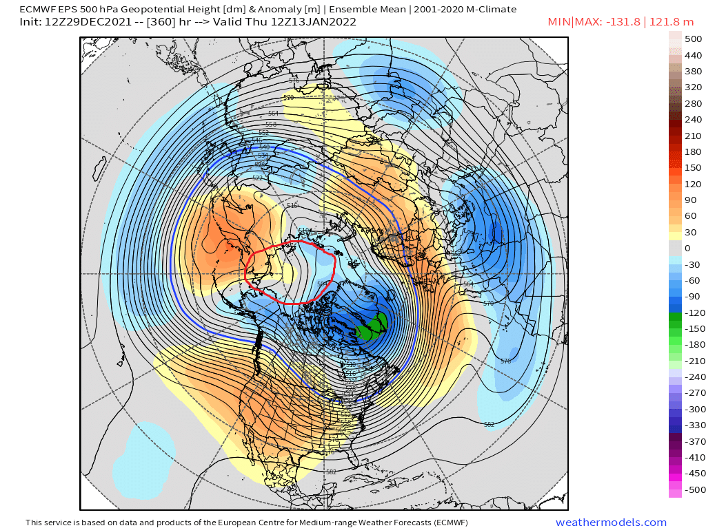
Yeah EPS is still totally fine but GEFS would be better. EPS actually starts retrograding the western ridge a bit at the end to a nice spot.
-
Man the GEFS and EPS are pretty different in the N PAC in the 11-15. GEFS has a nuclear EPO ridge…almost 2015-Esque. EPS are really lowering heights in AK though there is still some cross polar flow to the N of AK
-
Euro still liking 1/7 for something trackable.
-
This is really surprising.
-
12/30/00 storm was pretty meh in ORH....we had about 10 inches and then a ridiculous dryslot.
-
I’m completely ignoring the 1/3 system until non-GFS guidance shows anything.
-
GFS actually has the 1/7 event now, though it’s a bit too far west for good snows. Still way out there, but EPS/Euro suite has been entertaining that system. So if you want something to latch onto, that system would likely be the best shot.
-
December 2021 Obs/Disco...Dreaming of a White-Weenie Xmas
ORH_wxman replied to 40/70 Benchmark's topic in New England
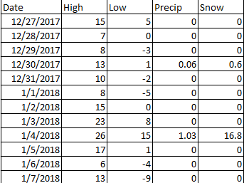
That stretch actually continued into January...had a reinforcement after the 1/4 blizzard. That was a pretty epic stretch if you look brutal cold sandwiched around a huge snowstorm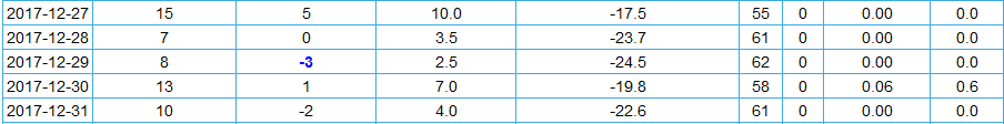
-
December 2021 Obs/Disco...Dreaming of a White-Weenie Xmas
ORH_wxman replied to 40/70 Benchmark's topic in New England
We had a hell of cold shot at this time in 2017 too...here's how ORH closed the month:
-
Not really...we've had plenty of La Nina ratters....the weird part is struggling in a La Nina when there has been a lot of high latitude blocking.
-
Oh yeah I missed that part. Yeah, 40” in a month is pretty sweet.
-
40 inches would be my worst winter ever since posting on these forums in 2004-2005.
-
18z GFS still trying to sell the frontal fraud on 1/3.
-
You need a more dominant northern stream +PNA pattern to get a lot of clippers.
-
EPS is still fine...has a piece of PV lobe getting sucked back into AK, but as long as you maintain cross polar (circled) flow, it's going to be good for cold source. It's probably going to flip to +200 dm anomalies next run anyway. I'm happier to see to some western ridging showing up.

-
Yeah the only exception i think is '84-85. 1954-55 had a big -NAO but a garbage N PAC.
-
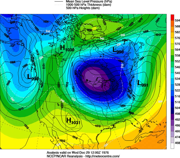
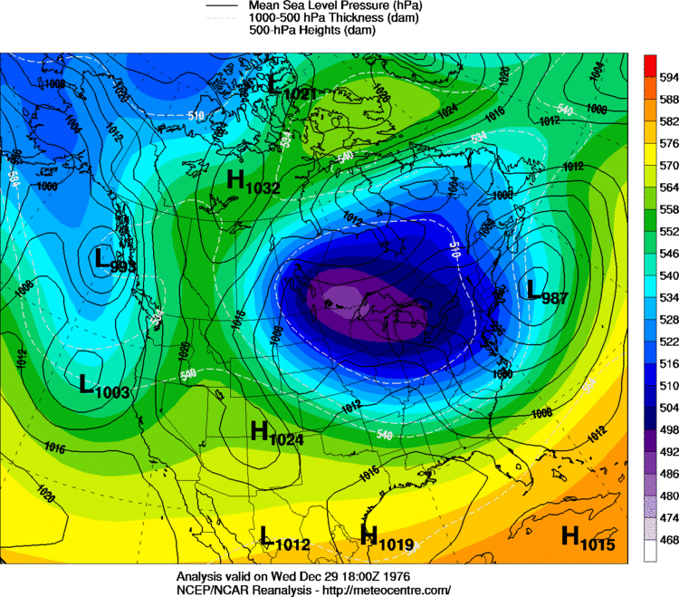
This is the 45th anniversary of the 12/29/76 storm....that really kicked off an amazing period for eastern MA...esp just barely W of BOS....like the 128 belt. This was Ray's dream storm. There was a band of 18-20" that went from N RI up through 128 belt....while ORH had 4".
-
It doesn't always mean doom though.....the blizzard sometimes ends a great pattern, but what happens in our good winters is that we don't get torched during the reshuffle. Think of the Feb 7-9, 2015 event when the rest of the country torched or the 1/18/11 front end thump to sleet/ice event after the NAO broke down post-1/12/11 blizzard and before the western PNA ridge popped to give us that great final 2 weeks of Jan 2011. My hope for this season (and Ray is prob thinking similar)....we enter a decent 2 weeks of neutral to slightly +PNA with a huge ridge over Bering/AK....then we start to reshuffle again, but perhaps that gets blunted by a -NAO forming....we very frequently see blocking return when earlier in the winter had big blocking. We'll see though....before we worry about ending a good pattern, lets actually get one first and get a damned warning event.
-
Sometimes the benchmark blizzard actually ends a great pattern....we've seen that many times.
-
Mean trough moves east by then so I think it will definitely help....wavelengths get a bit longer in January too which will help. We still have a monster ridge up in the Bering, so the cold supply is not going to be the issue assuming we move the mean trough eastward a bit. It's definitely not a one-eyed pig pattern.
-
Selling any frontal wave development....basically until inside 3 days and other guidance is on board.
-
December 2021 Obs/Disco...Dreaming of a White-Weenie Xmas
ORH_wxman replied to 40/70 Benchmark's topic in New England
Yeah I say luck too in place of "nuanced chaos" because most normal people will look at you like you have 3 heads when you start using that weird jargon. You can predict all the large scale features generally correct but be totally off on snowfall because of nuances in the flow. This goes back to my "loaded dice" post a couple weeks ago. You can play with loaded dice in your favor but still lose in the shorter term because the dice just happened to roll against you....just like you can beat the casino to a pulp at the roulette wheel for a night because the ball bounced in your favor a few times that night....but if you kept playing it, the casino will come back and beat you because the odds are tilted in their favor. Same exact idea applies to patterns....a pattern can be generally favorable, but nothing is 100%. We'd all definitely take a pattern that has a 60% chance of producing a big snowstorm over a pattern that has a 30% chance of producing one....but guess what? Sometimes the 30% pattern will produce one and the 60% pattern will not....but that does NOT mean we would take the 30% pattern again going forward. We admit we got "lucky" and hope the pattern gets better. -
No reason to buy the anafrontal wave idea unless it's showing up on all guidance and closer lead time. There's a chance the initial system could trend cold enough for NNE to be mostly frozen, but other than that, we can probably punt until at least 1/7.
-
Yep..get the scooter snowblower ready and your shovel to attack it.