ORH_wxman
-
Posts
90,902 -
Joined
-
Last visited
Content Type
Profiles
Blogs
Forums
American Weather
Media Demo
Store
Gallery
Everything posted by ORH_wxman
-
With omega that high in the sounding that dendrite posted, you also get garbage snow growth. Prob putrid bullets and plates which sublimate much faster too when they are trying to overcome dry layers.
-
Hallucinations are going to be epic tomorrow.
-
Yeah this is why I was laughing at the microanalysis of the 12z EPS. It took 6 hours to look different.
-
Yeah it’s amazing how many people immediately canceled winter after that post. Although many of them already canceled in December so not sure why the need to do it again…
-
Yeah it’s not even that bad of a look anyway, I just found the change funny. The ridge retrogrades back quickly into a pants tent pattern. But I’d obviously be cautious still.
-
It’s prob a red flag in the sense that something super amped up the Hudson valley is pretty unlikely. EPS are pretty far west compared to other ensemble suites too. So while I’d weight the EPS the highest, I would still add a little bit of weight to the others.
-
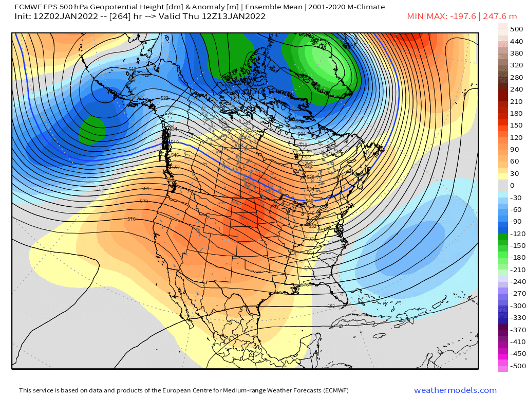
Lol EPS went right back to the low AK heights this run and then torches the country for several days before it reverts back to the good pattern.

-
It’s kind of weird that most OP runs don’t really have a primary up there but several ensemble members do. I’m not super worried about it at this point though. I can tell people are losing their minds when we’re analyzing the EPS individual members this much at 5 days out when it will probably look vastly different in a couple cycles.
-
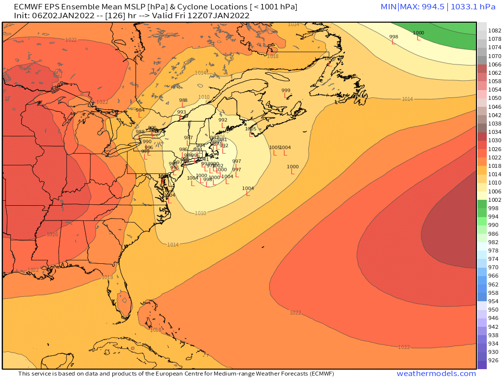
Those are primary lows in NY state.
-
There’s actually more spread on the EPS than the 06z run just eyeballing it.
-
Euro solution would make many happy except far SE areas and far NW areas. Spreads the wealth decently.
-
Ukie is an eastern special. But it does get most with at least advisory.
-
Looks like GEM will be a huge hit.
-
The RNA was always predicted, it just ended up a lot deeper than originally forecast. This one could fail too but it would probably take a larger model error because there’s more wiggle room when you have a western ridge.
-
That’s barely even a low…lol. Thankfully it’s been an outlier.
-
Don’t look at QPF on GFS. It’s way too far north based on the RH fields at 700 and 850
-
Yeah you basically are going to go from good snows to almost nothing. That GFS gradient is way too diffuse. Almost all that would be offshore the south coast.
-
Man, if that ML fronto can clip the cape or islands, they could get a pretty good storm. Too bad this wasn’t just a bit phased with northern stream.
-
Totally different pattern though. Not really analogous except in the loose sense that guidance could be wrong on the setup…but with a huge western ridge, it’s pretty unlikely we end up warm….unlike the extremely deep RNA trough where we ended up mostly on the wrong side of the gradient plus all those systems getting shredded during the times we were cold enough for snow.
-
Yeah regardless of 1/7, the pattern legit looks deep winter after that. Obviously getting a good system on 1/7 first is optimal, but it’s hard to see how we don’t get a lot of good chances beyond that unless guidance is clueless.
-
It’s all northern stream. We also don’t have a big western ridge yet when this storm happens so the flow is going to be pretty progressive…which will be competing with no downstream blocking. It will be a fast mover it looks like.
-
This thing is still 5 days out. Getting closer to more trust-worthy model lead time but I’d really wait another 2-3 cycles before getting confident.
-
There’s definitely a nice cluster near the BM but there’s definitely another set of lows that hug a bit more between NYC and BOS.
-
06z EPS members…still decent spread but tightening up compared to yesterday