

ORH_wxman
-
Posts
93,099 -
Joined
-
Last visited
Content Type
Profiles
Blogs
Forums
American Weather
Media Demo
Store
Gallery
Everything posted by ORH_wxman
-
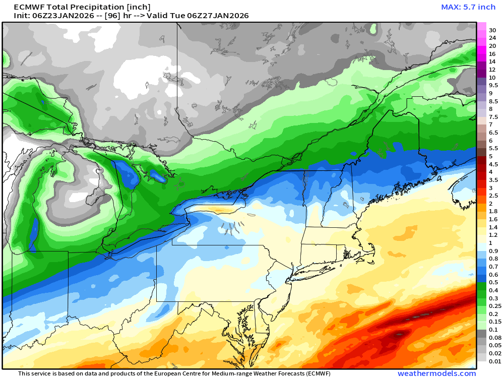
Prob 2” QPF on south shore if you allowed it to go another panel
-
NAM is gonna be good for Monday
-
Def a bit more confluence so far. But it was pretty jacked at 06z so not totally surprising.
-
Most is going to fall between about 4pm Sunday and 2am Monday. That’s 1-2” per hour stuff.
-
06z euro QPF for moneypitmike
-
Yeah I’d feel good with 12-18 forecast but not good about brushing 18”+ over anyone. I do think the south shore and Cape Ann have a pretty decent shot though with the extra OES enhancement. Still uncertain about how efficient monday is….on one hand, we’re synoptically dryslotted, but OTOH, you are literally in the DGZ sfc-700mb so it might not matter that much if you can generate some steady light precip…you could stack another 4-6” with maybe a quarter inch of QPF.
-
Congrats Scooter on 2 feet on the Ukie
-
Yeah I think your first guess is pretty good.
-
It’s clearly using some sort of ratio formula in addition to the QPF since that’s way more than 10 to 1 model consensus would imply.
-
Yes. I think some of these maps are on the aggressive side at the moment. Not that 20”+ is implausible here, but I think we’d need some things to go right for that to happen based on current guidance.
-
I don’t think we’ll see a 00z icon solution again. But we could see light precip on easterly flow overperform with high ratios. We’ll have a better idea of if that happens once we get inside 48h
-
Reggie looked like it was redeveloping a lot of low level precip at 84h.
-
The messenger shuffles are usually in coastals. Not SWFEs. Though this is a little bit of a hybrid. More SWFE, but there’s also a crazy anomalous airmass too.
-
Oh you’ll benefit from it but the best would be further up the slope towards ORH airport and Holden/Paxton/Leceister
-
21 year anniversary for one of the GOATs in SE MA and perhaps THE GOAT on the Cape. It was kind of meh west of ORH but what a ferocious storm for the east. The winds were very strong in this one and the airmass was exceptional. It was similar to the airmass this weekend.
-
Yeah those are the areas that would do better than others on Monday if we can keep solid easterly low level flow. South shore, Cape Ann, and eastern slopes of ORH hills. And then a bit of enhancement for anyone just west of CF…that’s kind of a wildcard for everyone’s forecast. Could produce a decent amounte of fluff on top of the rest of the storm.
-
The slow increase in QPF is a good sign right now too. In a lot of our higher end storms, they went from lower end “major” (like 8-14/10-15 type) on guidance into that 12-18/15-20 zone as we got inside 3 days. I agree with @Typhoon Tip that there’s sneaky potential on Monday with the lower level onshore flow being forced into the arctic dome…it’s one of those things that looks like mood snow or an additional 1-3” on guidance but then reality is 20 to 1 hooked aggregates that someone grabs an additional 7-8” on 0.37 of QPF….your snow growth zone is basically from the sfc to 700mb during that time so the lift being mostly low level doesn’t hurt as much as usual. Im still pretty ambiguous on how that will play out though. If we don’t keep the flow onshore, then it won’t be much but if we do, then things get more interesting.
-
That is a crazy good solution for most of SNE. Prob widespread 12-18” with a few higher lollis
-
Yes you could very well see additional snows on Monday. They aren’t necessarily confined the to eastern zones although it may be steadiest out east. But it should extend all the way back, especially if we maintain onshore flow.
-
January 2026 regional war/obs/disco thread
ORH_wxman replied to Baroclinic Zone's topic in New England
Textbook Miller B -
If we can keep onshore flow up to about 850-900 then I think we can tack on decent snows Monday/Monday night.
-
I think you’d want to see the trough open up more to get more of a norlun look. And the low would ideally be about our latitude but it might stay south and we stay with onshore flow.
-
January 2026 regional war/obs/disco thread
ORH_wxman replied to Baroclinic Zone's topic in New England
That’s the storm the GGEM was trying to crank but ended up as just a scraper. GFS is robust this time around. -
Yeah the NAM will be excellent for the midlevel warm nose once we’re inside a couple of days. It has to get the synoptics correct first which it usually takes until about 36-48h out.
-
Yeah i feel like any “issues” with ptype would be when the heavier stuff is gone…and that would also take a notable resumption of the northward trend which has mostly halted today. But if Mother Nature wants to try it, I’m here for it. It’s gonna be a steep cost in terms of dumping a ton of QPF as snow if we’re trying to get the mixing line up to the pike. My gut says that prob isn’t happening though with that airmass.


