

ORH_wxman
-
Posts
90,892 -
Joined
-
Last visited
Content Type
Profiles
Blogs
Forums
American Weather
Media Demo
Store
Gallery
Everything posted by ORH_wxman
-
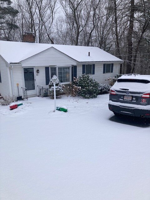
About 1.4” so far
-
Ripping right now. Def have over an inch eyeballing.
-
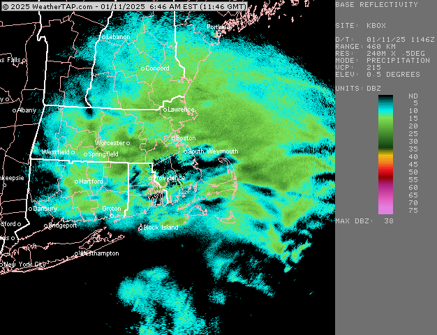
Weenie run for NE MA. Maybe someone can grab a 3 spot.
-
Yeah that’s the way it is around here. The smaller ponds with taller trees around them are solid. Drove past the small pond on Springdale ave in Dover today on way home from work and it’s pretty sheltered in a low area…not surrounded by tall trees like some others but it’s low laying….totally frozen with kids playing hockey on it.
-
We’re warmer than the mid-Atlantic today. Lol
-
Why is rain in the forecast?
-
Let’s see how many southern stations can have more snow than the Jetport by the end of next week. Lol
-
Would be nice to trend that 1/19 threat into a SWFE. There’s a lot of cold in the northern tier around that time.
-
Yeah I’m wondering if maybe we go like +2 in February instead of the usual Niña +4 or +5 that has happened in recent years.
-
3k NAM was pretty good around here and up into NH. I’d take a couple inches and run at this point since the cold isn’t going anywhere. Might as well look like winter on the ground. Still not convinced we get much, but there’s definitely an outside chance as a 2-3” zone for someone. Lot of instability aloft so maybe we can tap into that for a lucky surprise. Nothing else has really broken in our favor the last 2 weeks.
-
Weeklies try to torch us in February but I’ve noticed a pattern as we get closer that it’s no longer trying to put lower heights over AK/Bering. It’s keeping the WPO negative which may mitigate some of the expected warmup in February. I’m sure when the SE ridge flexes, we’ll have a 65F orgy for a couple of days with the usual suspects both on and off the forum pronouncing the beginning of spring (ala 2017 and 2018) but there could easily be a lot of cold just lurking to the north and advecting into our region at various intervals.
-
New England Winter 2024-25 Bantering, Whining, and Sobbing Thread
ORH_wxman replied to klw's topic in New England
Probably the most accurate way to build a classification model would also be the most labor-intensive. I’d probably take frequency thresholds into account at first order stations and start from that point. I know it’s easier for ORH to get a 12” storm than BOS or PVD. I know it’s easier for BOS to get one versus PHL or DCA. So you might calibrate the scale based on historical frequency of such events at each location…might kind of look like one of those maps of climate for plant hardiness. “You’re in zone 3 where you can’t plant tomatoes until this date, but if you’re in zone 4 you can do it a couple weeks earlier.” -
It can plausibly happen but we have to dodge a lot of storms between now and the end of February. Even imperfect setups in January and February can produce front enders and such. With so much cold around, there’s a decent chance we just run a system right into it at some point. Or maybe we’ll try and go ‘88-89 and keep whiffing, lol.
-
Most of the small ones I’ve seen here are frozen all the way but def some larger ones are open in the middle. The reservoirs in Southborough were open in the middle 2 days ago. But these smaller ponds near here that are nestled in basins with tall trees around them seem to be totally frozen.
-
I need to find a local pond to take the kids skating on. At least this weather is good for something.
-
BOS had almost 6” in the 12/20 event so they are BN but not horrifically like other spots further west. Just south of BOS is really bad on the south shore right on the coast.
-
Both can be true. We have a faster flow which maybe makes certain types of setups less frequent….but that maybe only explains a small percentage. Getting a +EPO might explain the majority of it. It’s like the snowfall argument…it’s an empirical fact we warmed between 1950-2020 but our snowfall empirically increased as well. So something else was offsetting the warming…was it extra water vapor? Yes, that explained prob a small percentage of it…but most of it was likely explained by natural variability and we just managed to get into a nice pattern of -AOs and -EPOs during that 2000s/2010s snow blitz. The extra 7% of water vapor in the atmosphere probably enhanced the nice pattern but it didn’t cause it.
-
That’s called a Miller B. We had about a century’s worth of them in the 2000s/2010s. Definitely not as many the last 3-4 winters.
-
GFS tries for a SWFE at D10. I almost forgot what those look like.
-
Yeah E Wareham is decent. Not close to pristine but pretty solid. I think their avg is around 39-40” since the turn of the century but long term avg is likely closer to about 35-37”. Much of the cape is likely low 30s and trending to upper 30s near the canal for longer term averages.
-
His map is based on coop data which is notoriously unreliable unless you know that coop is dedicated for snowfall. It’s too bad that a lot of coops degraded as we went through the years. Ironically, they were more reliable in days of yore when people didn’t travel as much or were home more often to do measurements at the right time (i.e. after snow ended or changed over and not the next morning when half of it might be washed away or compacted) N Foster coop is actually a good one though. Some of those coops north of them in MA near Milford and my region are horrific….usually at least 20-30% low. Maybe more. There’s precisely a 0% chance that southern ORH county averages near 40” a season…the worst spots there are prob in the 53-55” range and you have to be in the pit of the blackstone valley to get those numbers. Once you are at like 600-800 feet in Oxford/Southbridge/Douglas/etc, you’re gonna be near or over 60”. But sadly the bad coops are the only official data available so when you make a map, you’ll go with that unless you personally know certain areas are wrong. That’s a very nicely detailed map 4seasons has but I’d prob augment a lot of spots in S MA and NE CT.
-
NAM is def trying…it’s putting a pretty distinct inverted trough into New England.
-
New England Winter 2024-25 Bantering, Whining, and Sobbing Thread
ORH_wxman replied to klw's topic in New England
Yeah the magnitude of the winds really made a lot of other points moot. CA definitely has horrendous forest management which will continue to contribute to their fires, but I’m not sure how much difference it would’ve made in this instance. Maybe the fire doesn’t get quite as hot which helps on the margins for spreading, but with those winds, you were screwed regardless. -
I might have to stop lurking on Twitter and start trolling him.
-
New England Winter 2024-25 Bantering, Whining, and Sobbing Thread
ORH_wxman replied to klw's topic in New England
Yeah ORH broke the 2001-2002 seasonal warm record in back to back winters these last two years with a bad thermometer. No other first order SNE site has either of those winters as top dog. They were torch winters, just not record-breaking but we will erroneously think they are going forward. I think BOS set their warmest July on record in 2019 with an even worse thermometer. That was right before they corrected it but the record still stands today.


