ORH_wxman
-
Posts
90,902 -
Joined
-
Last visited
Content Type
Profiles
Blogs
Forums
American Weather
Media Demo
Store
Gallery
Everything posted by ORH_wxman
-
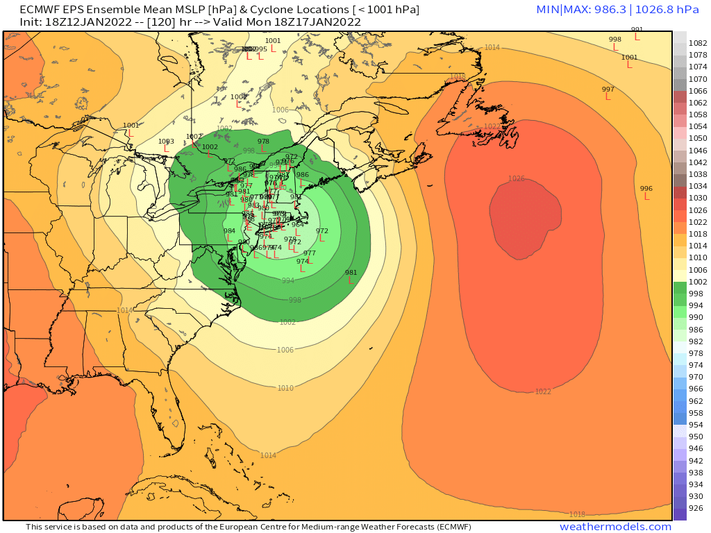
Monitoring a potential important TV to East Coastal storm: Jan 17
ORH_wxman replied to Typhoon Tip's topic in New England
Icon will be east of 18z. Still waiting for the useful models to come out. -
Monitoring a potential important TV to East Coastal storm: Jan 17
ORH_wxman replied to Typhoon Tip's topic in New England
Yeah I’d agree with that. The spread looks like it’s larger on the 18z run. -
Monitoring a potential important TV to East Coastal storm: Jan 17
ORH_wxman replied to Typhoon Tip's topic in New England
18z EPS actually looks a bit west of the 12z run. I’m on my phone so can’t really toggle but eyeball glance looks west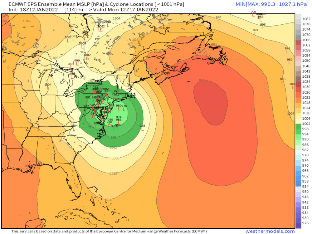

-
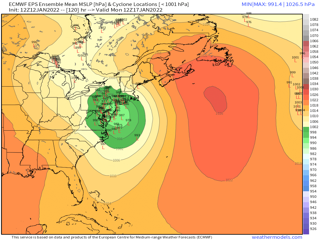
Monitoring a potential important TV to East Coastal storm: Jan 17
ORH_wxman replied to Typhoon Tip's topic in New England
It had the same trend as the 18z GFS with lower heights out ahead of it over New England. I think that would help the front end even if it tries to track west. -
Monitoring a potential important TV to East Coastal storm: Jan 17
ORH_wxman replied to Typhoon Tip's topic in New England
I don’t know if it’s more likely…it’s close enough for me not to be the arbiter of which one stays and which one goes. There’s definitely a western limit to this and BUF may be near that limit. There’s more room on the eastern side than on the western side…the skew won’t be a normal/Gaussian distribution. -
Monitoring a potential important TV to East Coastal storm: Jan 17
ORH_wxman replied to Typhoon Tip's topic in New England
We’d have to throw out the ones over BUF too if we did that. -
Monitoring a potential important TV to East Coastal storm: Jan 17
ORH_wxman replied to Typhoon Tip's topic in New England
It’s not super far from being a 12/16/07 type coastal. If you recall, that was originally supposed to track into BUF but the high got better and eventually we got a triple point over SE MA…and of course the big snow thump. -
Monitoring a potential important TV to East Coastal storm: Jan 17
ORH_wxman replied to Typhoon Tip's topic in New England
One reason to remain somewhat optimistic for more snow is that the antecedent airmass is strong, so if that high holds on just a shade longer, you prob get disproportional return on the snowfall in the positive direction. You can even see it on the some of the ensemble members. Some of the ones that hold onto the high just a smidge more thump 8-12" in a pretty large area over SNE. -
I love how the 3km NAM tracks the storm almost right over the BM but it doesn't get precip much past PYM.
-
Wind gusts?
-
Trough is a little broader than 12z though....so it prob won't tuck that precip shield back as far west.
-
Trough is def hanging back west of the 12z run through 24 hours. Doesn't mean it will end up better at the surface, but that's a general trend you want if there's any hope of getting this another 50-75 miles west....you want the trough to not be as progressive.
-
Yeah well the reasons are obvious we don't want people to compare anything to 2015. They will just think it means we're gonna get tons of snow again like that year. But the pattern is remarkably similar going into late January this year. Hopefully we can at least get a pretty snowy period....we don;t expect 90-100 inches in 3 weeks, but even a third of that would be pretty awesome.
-
Whats funny is the huge cutter in Jan 2015 that caused many to throw in the towel happened on 1/18...a day after this storm will happen...and an almost identical pattern was being shown for the final 2 weeks of that month that the EPS are now showing.
-
Scooter, you are required to click the link above
-
https://getyarn.io/yarn-clip/3e7b64fd-46bb-4cbb-bcff-b1e62839733f

-
Monitoring a potential important TV to East Coastal storm: Jan 17
ORH_wxman replied to Typhoon Tip's topic in New England
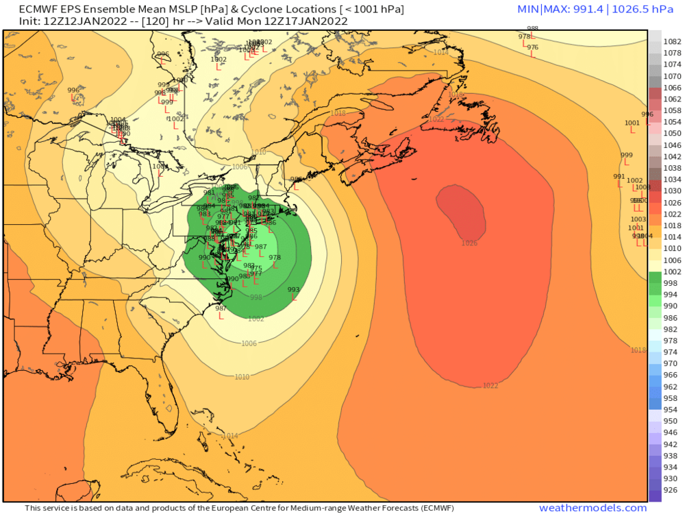
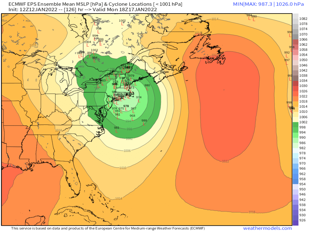
-
Monitoring a potential important TV to East Coastal storm: Jan 17
ORH_wxman replied to Typhoon Tip's topic in New England
I mean, it wouldn't take much more to do that...it goes from ABE to ALB. The initial confluence did seem to make the front end a little colder this run though...so if that is a trend that we can keep up, then we might be able to get a triple point low further east in later runs. -
Monitoring a potential important TV to East Coastal storm: Jan 17
ORH_wxman replied to Typhoon Tip's topic in New England
The 1980s would be 1-3" washed away completely. I'm hoping this can morph into a 8-10" front ender that gets compacted down to like 5-6" and then FROPA. But these westward trends may not be done yet. -
Monitoring a potential important TV to East Coastal storm: Jan 17
ORH_wxman replied to Typhoon Tip's topic in New England
That would probably be a hellacious thump for several hours though. -
Monitoring a potential important TV to East Coastal storm: Jan 17
ORH_wxman replied to Typhoon Tip's topic in New England
If this system was progressive at all, we'd prob be in pretty good shape, but it just stops gaining longitude. -
Monitoring a potential important TV to East Coastal storm: Jan 17
ORH_wxman replied to Typhoon Tip's topic in New England
This is gonna cut into NY State.... -
Monitoring a potential important TV to East Coastal storm: Jan 17
ORH_wxman replied to Typhoon Tip's topic in New England
Shotwave #3 looks to be digging more this run too....which will send our southern shortwave straight north...so I bet this run ends up west of 00z. -
Monitoring a potential important TV to East Coastal storm: Jan 17
ORH_wxman replied to Typhoon Tip's topic in New England
Yeah that shortwave down south seems to just be able to slow down if it needs to and wait for the confluence to lift out. This will probably still be a pretty far west run....but I'm hoping it's a little east of 00z....any eastward ticks will help.