

ORH_wxman
-
Posts
90,902 -
Joined
-
Last visited
Content Type
Profiles
Blogs
Forums
American Weather
Media Demo
Store
Gallery
Everything posted by ORH_wxman
-
Monitoring a potential important TV to East Coastal storm: Jan 17
ORH_wxman replied to Typhoon Tip's topic in New England
Once the NAM sniffed out that warm layer aloft, you knew it was time to take ‘em down on the front end snow totals. It’s rarely wrong on that part. All the globals will keep slowly ticking toward it….kicking and screaming if need be but they will submit. -
Canadian nailed the BGM track but any big snows here it will fail miserably.
-
Monitoring a potential important TV to East Coastal storm: Jan 17
ORH_wxman replied to Typhoon Tip's topic in New England
Yeah even the interior will touch low 40s I think except once you get deep interior like back toward hippy and the Berkshires. -
Monitoring a potential important TV to East Coastal storm: Jan 17
ORH_wxman replied to Typhoon Tip's topic in New England
Under the the winds here. Coastline should rip though. -
Yeah shows how shallow the arctic airmass is. If it was a deeper airmass then MWN would be pimping -30s.
-
Monitoring a potential important TV to East Coastal storm: Jan 17
ORH_wxman replied to Typhoon Tip's topic in New England
Before I knew snow climo I used to always think they got way more than ORH did. I didn’t start figuring it out until maybe when I was about 13 or 14. I had thought the same thing for Springfield too but the December 1992 and March 1993 storms both made me figure it out…but back then prior to internet, I hadnt realized Albany got screwed in Dec 1992. I didn’t read about it until a few years later. -
Monitoring a potential important TV to East Coastal storm: Jan 17
ORH_wxman replied to Typhoon Tip's topic in New England
Overall jackpot will be out in western/northwestern NY state and adjacent Canada…but you very well may be the New England jackpot. That area is great on easterly flow. -
Monitoring a potential important TV to East Coastal storm: Jan 17
ORH_wxman replied to Typhoon Tip's topic in New England
Agreed. I hadn’t read this post yet but when I responded to hippy i mentioned the sfc warmth is overdone on some of these runs. I think at minimum a triple point low goes over SE MA or close to there (maybe BOS?). I think the midlevels are cooked though based on the upper air evolution. -
Monitoring a potential important TV to East Coastal storm: Jan 17
ORH_wxman replied to Typhoon Tip's topic in New England
Agreed. My gut says this keeps warming aloft until about 24h out. Then maybe we get a little messenger tickle but most of the damage will be irreversible by then. I think the sfc warmth is overdone in the deep interior though so it wouldn’t surprise me to see some decent icing and sleet too. -
Monitoring a potential important TV to East Coastal storm: Jan 17
ORH_wxman replied to Typhoon Tip's topic in New England
NAM def colder than 12z....but 12z was an epic torch....18z is just merely a torch. Still warmer than the global guidance despite being colder than its own 12z run. -
Monitoring a potential important TV to East Coastal storm: Jan 17
ORH_wxman replied to Typhoon Tip's topic in New England
It might be too generous if some of these solutions that have the ML warmth in here almost at go-time end up being more correct. But he could also get 5-6" if things break right. -
Yeah, that's the whole "She's not gonna let us out" joke....we want to just let it go but this winter won't let us. Showing a totally loaded pattern going forward so it makes it hard to just punt. I think she just wants to torture us....
-
EPS likes 3 different windows....first one was Jan 22-23....second is Jan 27ish....and last is Jan 29. But in all honesty, any of the dates between about Jan 21 and the end of the run are primed. It was just focusing on those ones where we see a mean low pressure near the BM or just to our east.
-
1980s we’re a decent decade for the midatlantic too. So then getting h it a few times definitely fits the 80s theme.
-
Monitoring a potential important TV to East Coastal storm: Jan 17
ORH_wxman replied to Typhoon Tip's topic in New England
As soon as the rest of us move to the shoreline. -
Monitoring a potential important TV to East Coastal storm: Jan 17
ORH_wxman replied to Typhoon Tip's topic in New England
Yeah the NARCAN maps are likely better in this situation. -
Monitoring a potential important TV to East Coastal storm: Jan 17
ORH_wxman replied to Typhoon Tip's topic in New England
Yeah it looked a little less crazy amped at H5....but small differences. The small difference do matter, but it's hard to tell if they are real when they are small. Could be model noise. Hopefully we get another couple ticks colder and it would vastly improve the overall tenure of the storm. -
Monitoring a potential important TV to East Coastal storm: Jan 17
ORH_wxman replied to Typhoon Tip's topic in New England
The precision at which we get porked in this storm against a plethora of snow-bound analogs is pretty funny though…in a masochistic sort of way. I have done this for 3 days now, but yet, I’m still shocked every time I look at the 4-panel map 24 hours prior to this storm hitting and say “this is going to be mostly a rain event”. It’s amazing. You’d think there was no way. Sure, we’ve had 0F to 45F rainers 12 hours later before but you could easily see it coming when you viewed the maps. This time, it’s not obvious at all until you get to lime T-12 hours or so. Truly surgical precision of getting shafted out of a MECS/HECS type storm. -
Monitoring a potential important TV to East Coastal storm: Jan 17
ORH_wxman replied to Typhoon Tip's topic in New England
Yeah we'll see...maybe that shortwave comes in weaker. I am admittedly going on anecdotal evidence. Maybe @OceanStWx has some insight onto the statistics of incoming shortwaves recently...if they've been stronger or weaker after being sampled. -
Monitoring a potential important TV to East Coastal storm: Jan 17
ORH_wxman replied to Typhoon Tip's topic in New England
Yeah if there is a "colder" bust with this system as it pertains to sensible wx, I think the most likely scenario is that model guidance ends up too eager to erode the arctic airmass. I'm skeptical of any large scale changes aloft...in fact, I'm actually expecting that last northern stream piece to come in even stronger when sampled since that often seems to be the case, but we'll see. No guarantees in this business. However, if model guidance does a semi-poor job at resolving this lower level arctic airmass, then it could be too aggressive pushing that 805-925 warmth into here, so I'm open to the idea that we end up a bit snowier because of that.....but I'm putting that scenario as still unlikely. -
Monitoring a potential important TV to East Coastal storm: Jan 17
ORH_wxman replied to Typhoon Tip's topic in New England
Maybe we can blow Scooter's roof off on the GFS? Nice little mesolow over E MA. -
Monitoring a potential important TV to East Coastal storm: Jan 17
ORH_wxman replied to Typhoon Tip's topic in New England
It's negligible....the SSTs that is. SSTs aren't the reason this is over BGM instead of the Cape. -
Monitoring a potential important TV to East Coastal storm: Jan 17
ORH_wxman replied to Typhoon Tip's topic in New England
Yeah well said....It's amazing that not a SINGLE analog is as far west as the current storm on guidance....but guidance is in such good agreement, you can't go against it at this lead time. -
Monitoring a potential important TV to East Coastal storm: Jan 17
ORH_wxman replied to Typhoon Tip's topic in New England
Here's your NAM clown map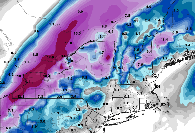
-
Monitoring a potential important TV to East Coastal storm: Jan 17
ORH_wxman replied to Typhoon Tip's topic in New England
Yeah we get a literal perfect storm of shortwave phasing to send it due north (or even NNW) when even a 010 or 020 vector would be fine. Funny how every single CIPS analog does not go as far west as this one does.


