

ORH_wxman
-
Posts
90,902 -
Joined
-
Last visited
Content Type
Profiles
Blogs
Forums
American Weather
Media Demo
Store
Gallery
Everything posted by ORH_wxman
-
May have to watch for wave along the front Wed night/early Thu.
-
Monitoring a potential important TV to East Coastal storm: Jan 17
ORH_wxman replied to Typhoon Tip's topic in New England
Dover NH -
Monitoring a potential important TV to East Coastal storm: Jan 17
ORH_wxman replied to Typhoon Tip's topic in New England
Yeah N ORH county will prob do decent…they will have some assist on the east flow too with a little bit of orographic cooling. I don’t think it’s going to be that good south of there. I’m expecting maybe a couple sloppy inches…but wouldn’t be surprised if I end up with less than that. I’d consider it a huge win if I scored more than 3”. -
Monitoring a potential important TV to East Coastal storm: Jan 17
ORH_wxman replied to Typhoon Tip's topic in New England
No, I don’t think ZR/IP will be much of a big deal at all in SNE. The warmth between 925-sfc comes in before it does aloft. So I think it goes almost straight to rain from snow…maybe a very brief period of ZR/IP for a few spots. -
Monitoring a potential important TV to East Coastal storm: Jan 17
ORH_wxman replied to Typhoon Tip's topic in New England
This likely becomes very elevation-dependent in the final couple hours before the flip to rain. We could see a scenario where after 2” of snow, I get 2 hours of 0.20” QPF/hour of massive wet aggregates at 34F but it only adds another inch or less while ORH grabs another 3” of paste in that same 2 hour span. -
Monitoring a potential important TV to East Coastal storm: Jan 17
ORH_wxman replied to Typhoon Tip's topic in New England
Correct. At least for most of SNE/CNE (different story back in interior NY and PA) Very little sleet in this as the warmth comes in at the low levels first. -
Monitoring a potential important TV to East Coastal storm: Jan 17
ORH_wxman replied to Typhoon Tip's topic in New England
Honestly not sure what to make of this. There’s arguments both ways. Synoptically this is pretty awful for snow with that rapid high pressure retreat and the pressure falls mostly being to the west rather than southeast when redevelopment is attempting my to take place when we get a typical front ender…however, this antecedent airmass is really strong so there’s a case to be made for the models trying to flush that high a little too quickly. If it hangs back even a couple hours longer than models think, then it’s going to bust positive for snow. I’d prob still hedge mostly on the lower side of guidance but I would put a little bit of weight on the HRRR/3km type solutions. I do think there should be a few hours of moderate to heavy snow even down in CT at the start. Sfc temps may dictate how well that accumulates. If the heaviest stuff is at 33-34F then it won’t be that efficient obviously. It’s a semi-interesting nowcast. We can see how the short term guidance keeps trending today. Esp this afternoon. I will say that the last 4-5 cycles of HRRr keep slowing the high retreat. 15z coming in right now is doing it again. -
Monitoring a potential important TV to East Coastal storm: Jan 17
ORH_wxman replied to Typhoon Tip's topic in New England
Yeah it’s not really that exciting unless we score 5-6”+ but I guess it’s slightly better than all rain. Mostly useless stat padder when you get 2-4” that’s wiped out a few hours later. But who knows, maybe we’ll get a positive surprise given the cold antecedent airmass. But usually this synoptic setup isn’t conductive to the positive bust…feels more like negative downside is the skew. You want to see a high being slower to move out than modeled to have a chance. -
Monitoring a potential important TV to East Coastal storm: Jan 17
ORH_wxman replied to Typhoon Tip's topic in New England
Seems like a solid map. I doubt I would change much. -
Monitoring a potential important TV to East Coastal storm: Jan 17
ORH_wxman replied to Typhoon Tip's topic in New England
3km NAM is pretty cold on the front end this run. Tries to give several inches here. -
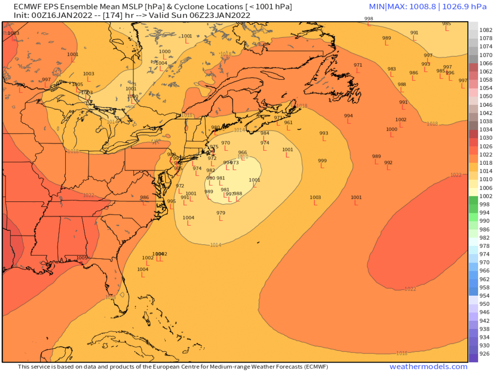
EPS only goes out to 144 at 06z
-
00z EPS
-
Monitoring a potential important TV to East Coastal storm: Jan 17
ORH_wxman replied to Typhoon Tip's topic in New England
I’m not. We’d need a significant bump SE to not be in the 40s for hours. -
Monitoring a potential important TV to East Coastal storm: Jan 17
ORH_wxman replied to Typhoon Tip's topic in New England
I won’t be shocked if there’s still a hideous glacier intact over Kevin’s lawn on Monday but I’m not sure what the debate is worth anyway…I don’t think it would be more than 2 or 3 inches anyway. But 6-8 hours in the 40s with rain will be tough to fight off. Usually you want like an inch-plus of water in the pack to fight that type of assault off. -
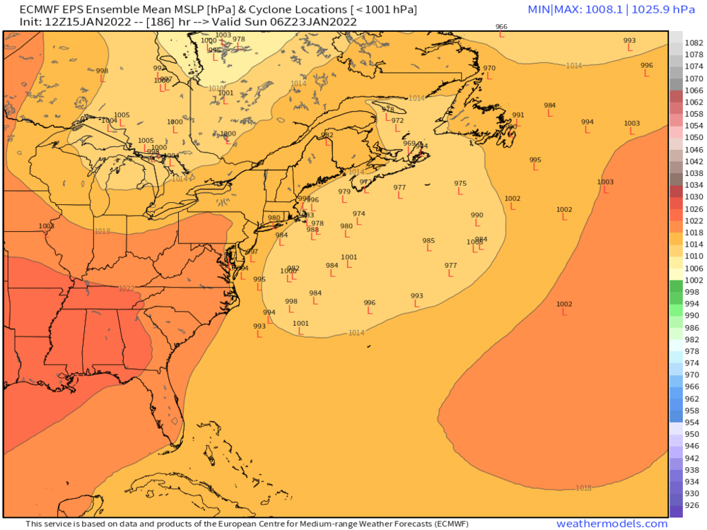
EPS has some interest in the system. Obviously far out but a definite signal there
-
Monitoring a potential important TV to East Coastal storm: Jan 17
ORH_wxman replied to Typhoon Tip's topic in New England
None of these trends matter for SNE except maybe N ORH county and Berkshires. We need something more substantial than minor ticks. -
Ineedsnow chose that one. But he called it by its TWC name Nemo.
-
Monitoring a potential important TV to East Coastal storm: Jan 17
ORH_wxman replied to Typhoon Tip's topic in New England
Yeah the Euro is the only model that still basically has a snow sounding at ORH (and just north of them) by 12z Monday. Tossed. -
Monitoring a potential important TV to East Coastal storm: Jan 17
ORH_wxman replied to Typhoon Tip's topic in New England
Lol, trying to give ORH 8-10” this run. Not buying it. Euro is going to fold like a cheap suit to the NAM I bet. -
Dec 1992 for ORH. Prob Feb 1978 for Holliston but Dec ‘92 was sneaky good here too. So was April ‘97.
-
Monitoring a potential important TV to East Coastal storm: Jan 17
ORH_wxman replied to Typhoon Tip's topic in New England
I dont think anyone here except maybe one or two of the most star-eyed weenies thinks 2015 is happening this year. There are plenty of other examples though of non-El Nino late blooming winters like 2012-2013, 2000-2001, 1955-56, 1966-67, etc. -
Monitoring a potential important TV to East Coastal storm: Jan 17
ORH_wxman replied to Typhoon Tip's topic in New England
This is a weather forum. People are going to discuss a large storm that has some impact on the region even if it’s not a blizzard in their backyard. -
That’s why having empirical data archived is really nice. You can debunk any false stories of “winters of yore” pretty easily if they don’t pass the smell test. We just check the data and see what they were like.
-
Monitoring a potential important TV to East Coastal storm: Jan 17
ORH_wxman replied to Typhoon Tip's topic in New England
I don’t think anyone here in this forum has seriously entertained a classic coastal look for a couple cycles now. -
Monitoring a potential important TV to East Coastal storm: Jan 17
ORH_wxman replied to Typhoon Tip's topic in New England
If there’s one aspect of the NAM that makes me a little hesitant to buy the solution is that 850 is a lot warmer than other levels. Usually the NAM hammers that 725-800 layer but it’s not doing that. It has this weird very thin torch layer around 850.


