ORH_wxman
-
Posts
90,902 -
Joined
-
Last visited
Content Type
Profiles
Blogs
Forums
American Weather
Media Demo
Store
Gallery
Everything posted by ORH_wxman
-
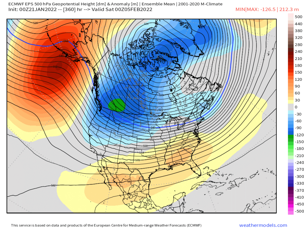
It’s basically a Feb 94 pattern. Monster AK/Bering ridge with western trough but Se ridge is crushed enough by the AK ridging that we are cold.
-
@CoastalWx
-
Southern stream actually takes a perfect track for us on the 18z gfs but it decides to screw us by having the northern stream lead a weak low over us and rob the baroclinic zone and antecedent airmass. That is perfectly on par for this winter though…ruin a good large scale setup because of some bizarre nuance.
-
Logan is at 12 or 13 inches now? Climo from here on out is prob like 28-30”. So they need less than half that to reach 25”. I’ll go out on a limb and predict a once every 4 or 5 decade type March probably won’t happen. Ain’t happening. That would be way too easy. You know the CFS will probably be more correct about February and we’ll get tortured to death instead of just pulling the plug.
-
Weekly mean pattern won't tell us enough detail to determine whether we get 70....given how rare 70 is (despite doing it twice recently in 2017 and 2018), it probably wouldn't be that type of warmth. Esp given the ridging still present over the Bering. You'd need an obscene western trough which is always possible, but you wouldn't predict that far out.
-
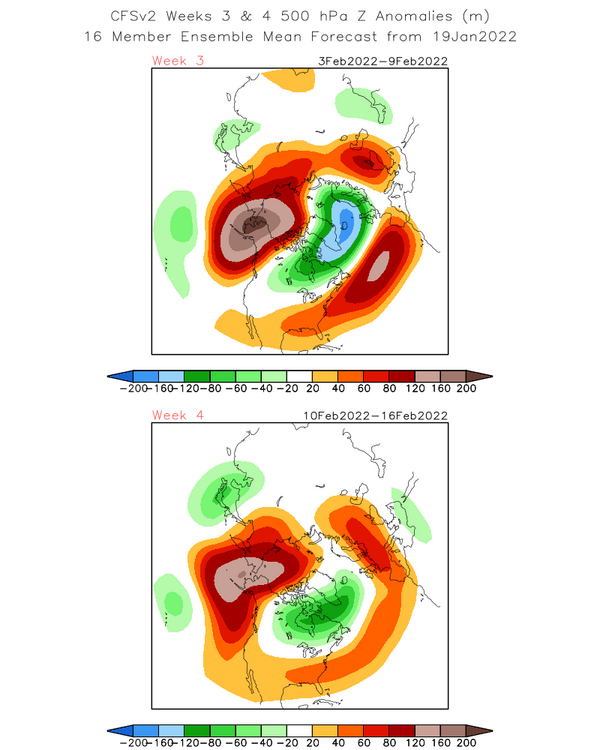
This is an all out torch for everyone in the east....but yeah, at 1500 feet in the whites you can still do ok as long as the pattern is active....which it probably would be given there is still PAC ridging into the Bering and then sending the PJ down into the west coast. But who knows....the weeklies aren't very useful beyond week 2/3...they aren't much better than the CFS in that range, and the CFS has a much colder pattern:
-
I’m sure it will flip post-equinox when it becomes useless. All joking aside, weeklies have been pretty insistent on February being done after the first week, so we’ll see if they are actually right this time. If we’re not gonna cash in between now and 1/30, I’m throwing in the towel on salvaging a normal winter…but of course I’ll still be rooting for a huge storm at some point. I’d make a deal with the devil and punt all of February if we could get a monster in March.
-
What an epic torch on the weeklies for February. We technically don’t have a February thread yet but that would basically end winter after the first few days of the month.
-
Yeah I'll check in on it each run, but not going to waste much time parsing it unless there is improvement....most likely outcome on that one is a nothing-burger shredded radar deal.
-
I dunno, it's pretty far north on guidance now....I'd want to see the southern stream inject some juice into that. Looks like one of those shredded radar 1" deals if we can't get more moisture....some previous runs were dipping that northern stream shortwave far south enough that we'd get the NJ-model redeveloper without any southern stream help, but those solutions are gone....too far north now....maybe they come back but I'm skeptical.
-
Storm gets kicked east this run. Scrapes E MA.
-
Euro is weak sauce for the clipper....whiffs on the southern stream phase (but it's close to have to watch this)....it looks like it's trying to cook up something good though for 1/28-29...we'll see.
-
H5 is deepening pretty rapidly south of LI and it cuts off bringing good deep layer E or ENE flow. You are prob getting whacked with ML fronto and the CF at the same time there for a while.
-
Ukie is weak with the clipper too...maybe 1-3". Doesn't go out far enough to see 1/29-30 but the pattern looks primed at D6 with some southern energy hanging down southwest waiting for the next northern stream wave.
-
GGEM likes 1/29....it has the clipper pretty weak on 1/25, prob only a 1-2" type job on the clipper.
-
It would still be a pretty epic storm even up this way because the WCB is so strong....almost like the superstorm...except further east. I'd take it and run and not worry if some hamlet in SE PA got 31" while I got 24".
-
Not easy to get sub-960 lows....nevermind at Cape Hatteras latitude, lol
-
Might have had some flakes stick on the grill cover. Epic.
-
Flash freezes typically happen in WINDEX events around here....you occasionally get them in a cold tuck scenario or a frontal wave, but usually they are from an arctic front that has snow squalls with temps starting in the 30s and then you drop like 10F in an hour and everything turns to a sheet of ice that was wet.
-
GFS trying for 1/25....need to consolidate the forcing into the southern stream, but it has a decent look.
-
Snowing here steadily, but radar looks like dogshit....hopefully we can grab an inch if that stuff to the west doesn't fall apart.
-
I mean maybe...but it's really hard to make up 50"+ in like a 5-6 week span which is where we'd be by early February....for the epic snow belt towns in south-central CT, they have more wiggle room to reach average, but up here, we're way behind climo and you need snow events every so often not to fall too far behind.
-
Yeah I think the next 10 days will decide how this winter will go...if we cash in on 2 threats, then something close to normal snowfall is still plausible. But if we get to groundhog day with nothing to show for it and nothing imminent, I think a ratter is basically locked.
-
Frustration on this garbage winter aside....if we're looking for the best windows here, it's still Jan 25-26....there is still pretty decent ensemble support for that system. Then I'd prob look at Jan 29-30th and Feb 2nd....those are two dates that have some weak ensemble signals.
-
Some mangled flakes mixed in here. Epicosity.