ORH_wxman
-
Posts
90,902 -
Joined
-
Last visited
Content Type
Profiles
Blogs
Forums
American Weather
Media Demo
Store
Gallery
Everything posted by ORH_wxman
-
Yeah I think the key is not having it bury itself so far south....but there is a lot of time for that to change. When I look at the D7 map at H5, there's some pretty good potential to make that a big system for us without screwing around for another 48 hours.
-
Lol, I feel like that probably won't verify...that is actually a lot warmer than last Monday's storm.
-
We are gonna need that northern stream to draw it north.
-
i've always loved the snowfalls where you can look up and see the shadowed aggregate clumps against the white sky. That pic has it to the extreme....very large aggregate clumps....likely hooked dendrites of course given the BL temps in the snow growth zone. Probably 20 or 25 to 1 fluffer nutter.
-
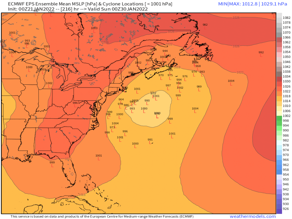
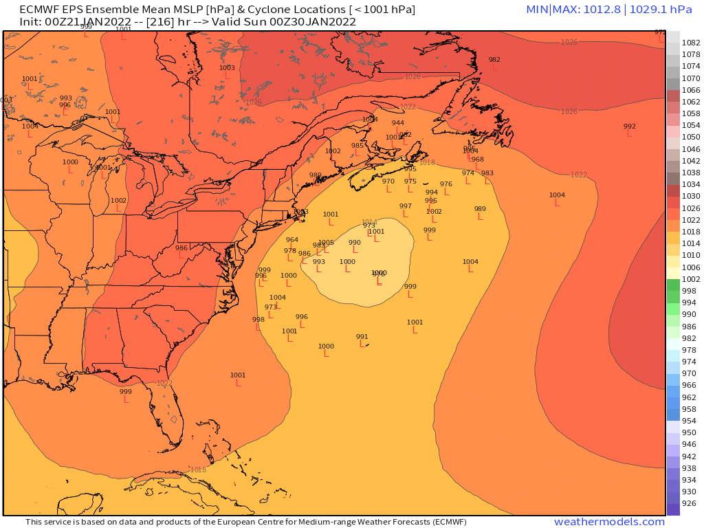
This looks like a different system....that's 264 hours and the system we're tracking is more like 192-216ish.
-
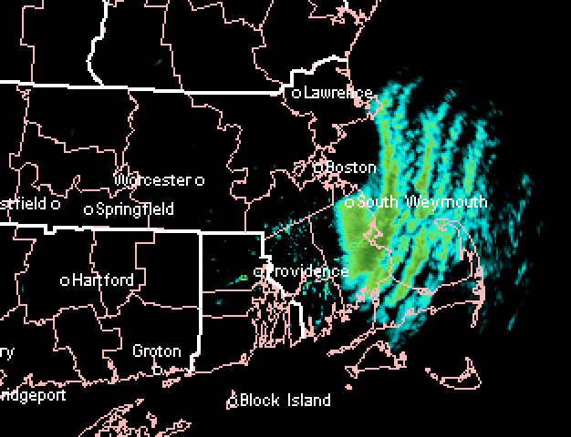
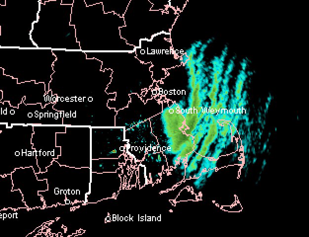
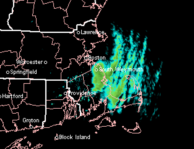
You might end up with 6"+ by the time we get to tomorrow lunchtime. It'll be interesting to track but theoretically it might be even better OES late tonight and early tomorrow....but these are often very quirky as I"m sure you are aware. This is a really impressive streamer though that has set up over PYM county.
-
I'm not expecting much from it, but there were two sort of "interesting" potentials with that one....the first potential was solely northern stream giving us a NJ-model redeveloper....that idea went out the window a few cycles ago when the northern stream trended too far north. A second emerging "interesting" scenario started showing up when that energy in the southwest got ejected and rides around the base of the northern stream giving the system new life for something bigger than a 1-3" nuisance event. I think the southern stream scenario is tougher because it requires both good timing and also having the southern stream maintain its integrity long enough before getting ground up by the geopotential gradient.....but the GGEM shows how its done. Ukie was fairly close but the shortwave weakened a little too quickly.
-
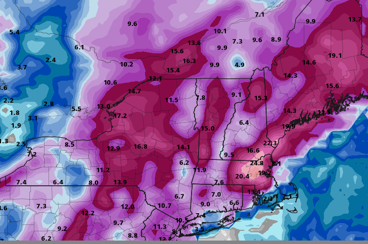
Someone further northeast must have 4"+ by now...that band is just hammering Kingston/Duxbury/far northern PYM.
-
Yes, you can get on board with that southern wave and ditch the moose farts for this one. This one can snow decently for most of the forum. They'll be plenty of other chances for moose flatulence.
-
12z Ukie trying on 1/26 too...nuisance event in the end, but not far off from a GGEM solution.
-
Yep....I'm already resigned to having a below normal snowfall winter, so I'd take the HECS and run if offered right now. I'm aware that there is still the chance we get lucky and rip off a great 3-4 weeks somewhere in there, but I wouldn't trade a big storm for that longshot chance.....not that any of have the choice anyway, lol....but that is where my mindset is at. I'm shooting for the big bucks at this point, not the small game.
-
Yeah it makes the southern low more dominant and it's able to get a decent WCB going plus some ML fronto on the backside
-
Ray and I would prob trade the rest of the winter to get this one to verify
-
LOL....it tries to pull a December '92 with the easterly deep layer flow and just annihilate eastern SNE with QPF.
-
Yeah the northern stream only draws it due north when the low goes through BGM....when we need it, it will act as a kicker. That's what happens in a White Snake winter like this year.
-
This could actually end up a comical solution for us too....because the ULL rots so long down south, the kicker s/w actually catches up to it and might draw it northward.
-
Nice output this run for the south....I love the 36" spot over Augusta GA....Butler Cabin roof collapser at the Masters?
-
You'd get hit harder than a 2-4" moose fart if that northern stream system wasn't mucking it up. It's not just an SNE thing.
-
It's got no choice...it has to with that ridge folding over it. Hopefully on future runs it lessens that feature and then we'd be in prime position.
-
Lets see if we can give Atlanta a CCB this run....that's a pretty monstrous ULL down south on the 12z GFS. Not gonna hit us though this run with a ridge folding over like that.
-
26th looks like a nuisance event....just can't keep the northern low from mucking up a great southern stream track.
-
I wonder if someone can get 6"+ down there....the OES actually may pick up even more as we work through tomorrow morning as that offshore coastal increases the flow and LL convergence.
-
Duxbury/Kingston getting smoked
-
We absolutely cannot buy a classic juiced SWFE recently....either the antecedent airmass is crap or even when it's decent, something goes wrong like the shortwave is sheared and tracks through Ottawa or something. At some point that is going to change. Hopefully it's this winter.
-
00z EPS has a few decent members west...several more than 12z had