ORH_wxman
-
Posts
90,902 -
Joined
-
Last visited
Content Type
Profiles
Blogs
Forums
American Weather
Media Demo
Store
Gallery
Everything posted by ORH_wxman
-
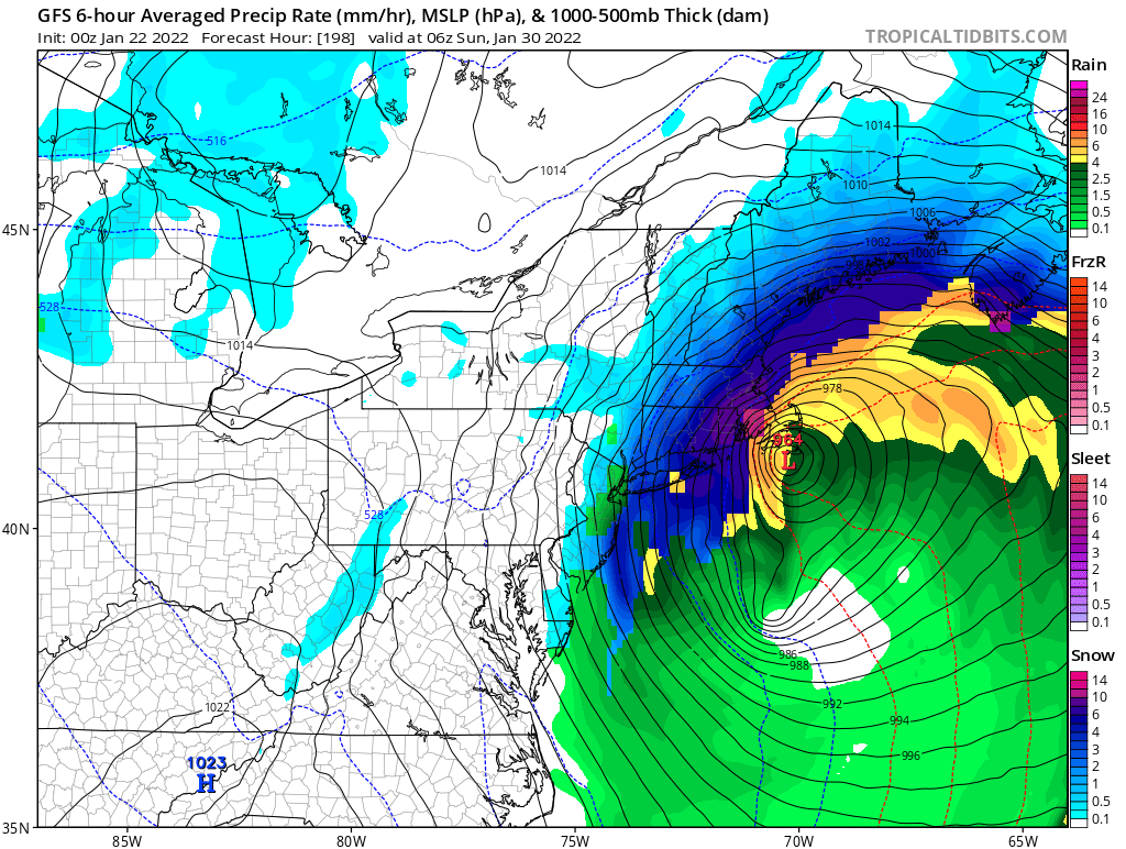
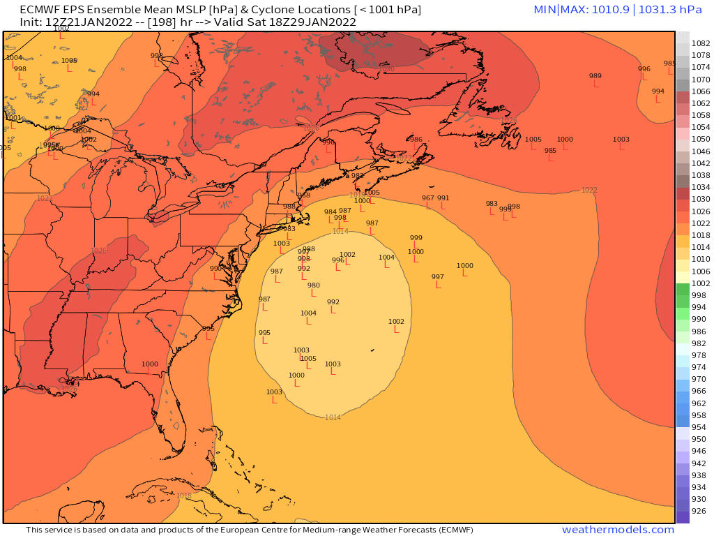
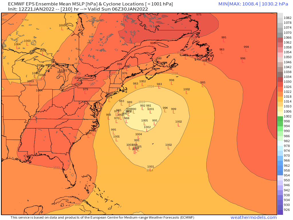
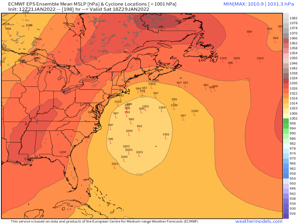
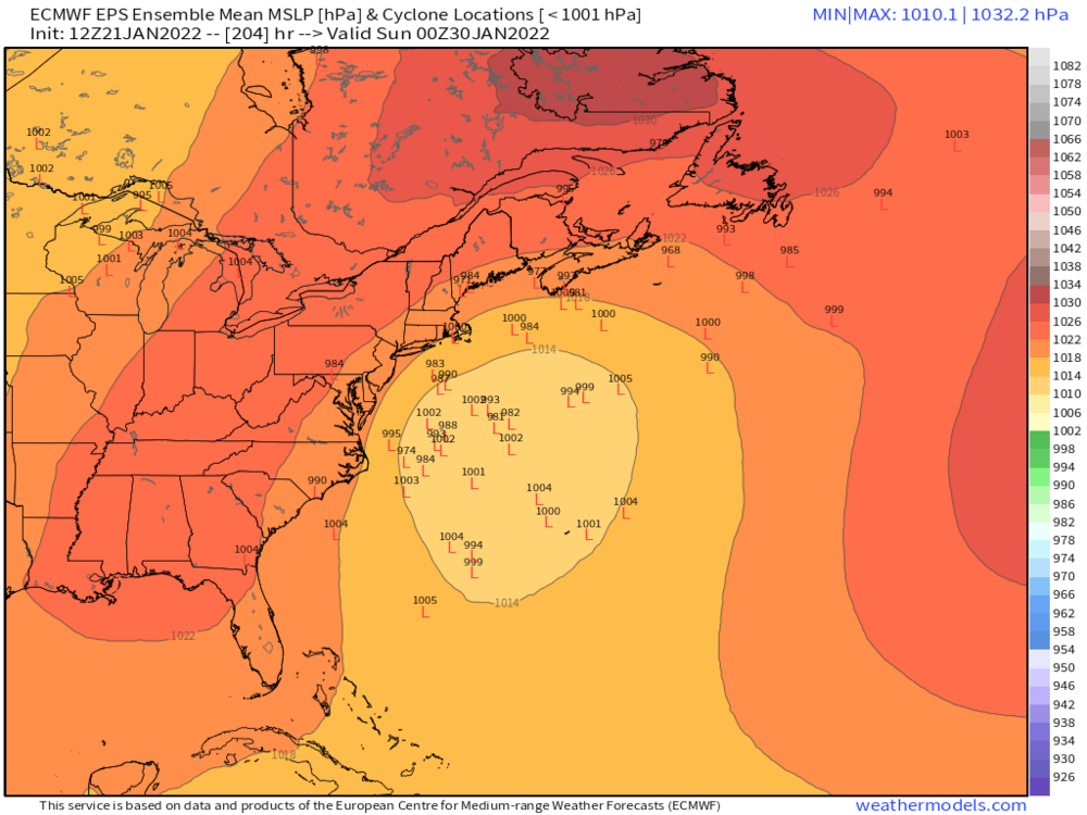
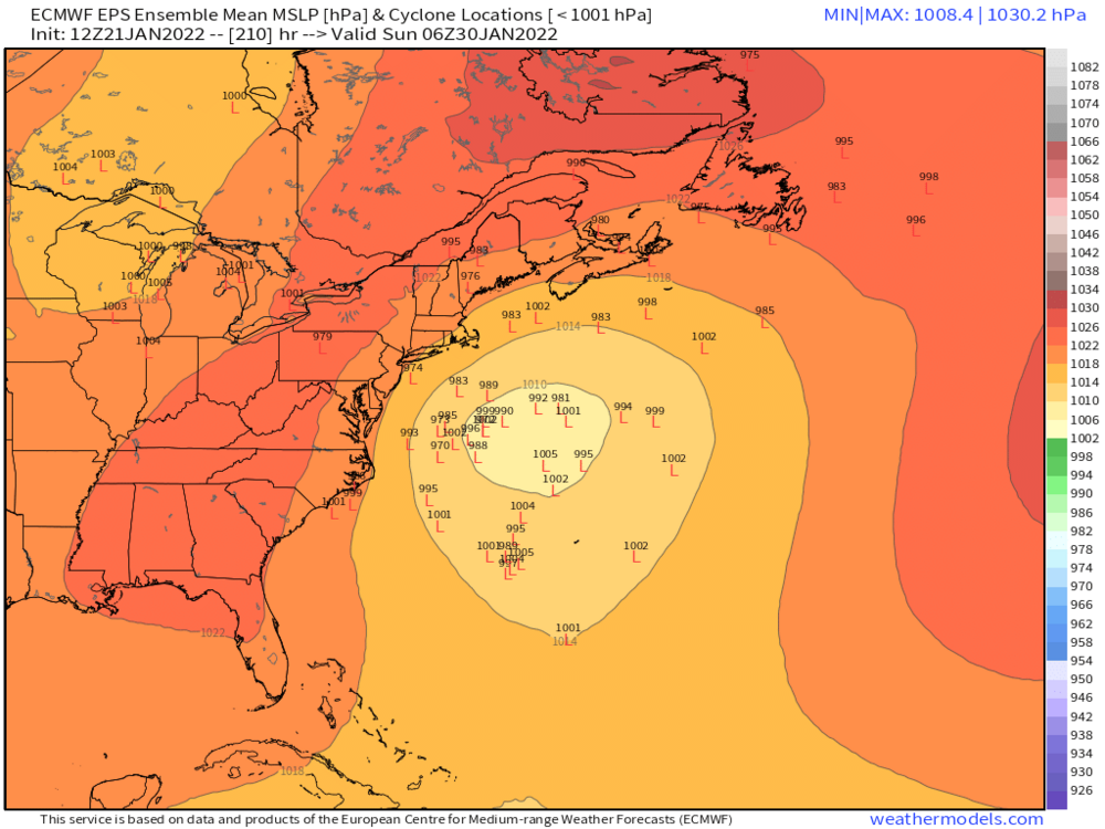
There’s two systems. D7 wide right this run and D9 is a hit. Both could miss but you really can’t ask for a lot more given the lead time.
-
Other guidance is mostly trash for Tuesday. Not biting on anything more than 1-2” yet. Would be nice to grab a bigger event but the other guidance doesn’t like the southern stream much anymore. Maybe we’ll get a shift back at 12z.
-
MWN employees cry at the claims of real cold by fake radiators. MWN lives being erased.
-
Please do explain more
-
Pretty rare to get air masses that don’t mix cold down unless it’s maybe spring time with sun and you get extra diabetic heating that is far more than winter. I’d call that fake warmth…like in March when when you have -2C 850 temps and sun the day before a big storm hits….you hit 52F but then when precip starts it’s in the upper 20th r lower 30s.
-
Semantics. Not representative of the vertical airmass like a well mixed surface is.
-
It’s kind of fake in that it goes away as soon as you mix out. Like many spots around here that were below zero will crack 20F today. There’s definitely a difference in radiaitonal cold vs advected deep cold. Yeah, pipes and cars still have problems but other things like wind chill and rate of daytime warming are vastly different.
-
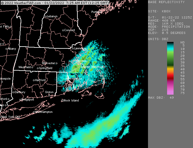
We have something a little “heavier” than flurries. It’s steady very light snow call it. It looks nice because of the perfect fat aggregates but it doesnt really add up to anything unless it does this for hours and hours.
-
Yes. This is all in the lowest 3000-4000 feet.
-
Yeah NAM is the last holdout.
-
Getting some really nice fatties right now…just massive clumped dendrite aggregates
-
Actually I’ll take that back…euro/NAM have trended south enough with northern stream that they do drop 1-2”…guess we’ll see if that can stick. But the southern stream idea seems to be going away.
-
Tuesday went to zilch on most guidance. Too bad. Was hoping that one could squeeze out an advisory event. Guess we wait and see if 1/29-30 will pan out.
-
Lol

-
18z GFS was run out of the EMA super weenie computer.
-
18z GFS looking healthier for Tuesday. Hopefully we can all bow to Rev Kev’s 4-8” when the time comes. I’m still skeptical but I’ve been keeping an eye on that southern stream.
-
I likely avg around 65 here...and I'm around 15 so far. 50" is a heavy lift from here on out. Not impossible but unlikely.
-
You have a much better chance to reach normal than I do (I already specifically mentioned that CT has a better shot)....you already have more snow than me on the year and your climo is lower. For a place like here that barely has 15" and needs another 50 to reach climo is much bleaker....it's possible, but odds are stacked against it.
-
Yeah for all intents and purposes, '78 was a Miller B...there's really no binary answer on most of these because we are able to observe a fart swirl in the low levels a lot better than we did back in the 1940s when the designations came out in the Miller paper. I would say Feb '13 was more of a hybrid than '78 was...but both were very northern stream dominant which is why they went insane on SNE. You could say the same thing for January 12, 2011 too. Like, technically there's a swirl down off FL as the storm approaches from the west, but do we really care that much when the dominant low is in the OH valley at first? That's kind of the distinction Miller made in his paper too....talking about a dominant low inland in the OH valley yielding to cyclogenesis on the east coast. I think that's really the spirit of the definition. Anyways, enough of the semantics before I derail the thread further.
-
Yeah I was slow-rolling the description there for a D8-9 threat. It is actually a very good signal for that far out....but I didn't want to start hyping too much. We know how different this could look tomorrow or the next day.
-
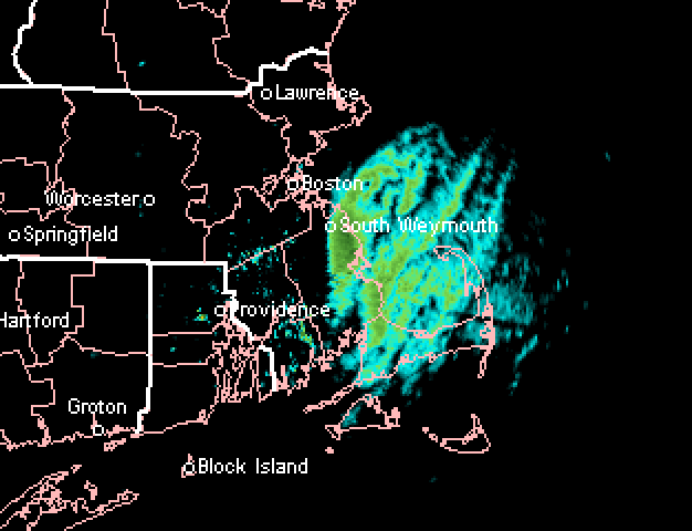
Awesome streamer...hitting Marshfield harder too than before:
-
Anyways, I've seen worse EPS runs than this at 8-9 days out....it's an eternity, but at least there is some cross-guidance support on this one.
-
Dude, once we whiffed on the last 3 threats, our fate was mostly sealed for a below average snowfall winter.....sure, we could rebound, but it's very unlikely at this point where we are. Areas further southwest in CT that have gotten a little more plus a lower snowfall climo to begin with have an easier path to getting to normal snowfall.
-
Yeah that was funny to me....Kevin does a rare map post and he decides to do it for an image that shows a light band of snow showers.
-
That looks pretty epic.