ORH_wxman
-
Posts
90,902 -
Joined
-
Last visited
Content Type
Profiles
Blogs
Forums
American Weather
Media Demo
Store
Gallery
Everything posted by ORH_wxman
-
NAM is actually kind of weird at 84...trough is not as deep and negative as Euro at same time, but the NAM is hugging the mid-level center west of the Euro...so who knows. Also analyzing 84h NAM nuances.
-
Yeah prob a little bit east of a Euro solution.
-
Some of the previous runs were def more Miller B-ish.....but once we started getting that southern stream becoming a big player, it became a Miller A. It can still almost act like a Miller B though if southern stream drags and/or the real deepening is delayed a bit.
-
The $14 million grand slam....it was actually game 6 BTW (still an elimination game as it was)
-
That was a grazer for eastern areas....funny, we narrowly missed a biggie there and I remember being kind of pissed, but then a week later we got payback.
-
Jan 2015 is still the closest IMHO but it deepens the trough a bit more in the southeast....it's almost a cross between that one and boxing day 2010. The larger scale trough/ridge positions are very close to Jan 2015 but the ULL itself is a little deeper down south sort of like Boxing day was....but not as deep as Boxing day, which is why I say it's kind of a hybrid between the two.
-
'78 was a totally different evolution....the impact could maybe be similar in a couple spots if this one is bad enough....but yeah, no reason to really break it out at this point.
-
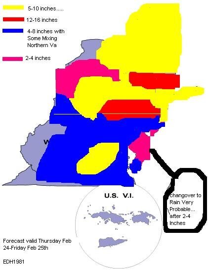
The solid white "snow" wouldn't appear until like 3 days out.
-
Euro is the only one closing this off with rapid H5 deepening that early and southwest...I don't think #2 is off the table whatsoever.
-
Just one more bump east like this run compared to 00z and we're in jackpot zone. Still a great solution as is.
-
Heights have been coming in lower over Nova Scotia on these runs too. That's where that "pinching" of the north side of the trough is probably coming from...or at least related to it.
-
Yeah this will be more subdued than 00z....not surprising though considering how amped that run was compared to other guidance.
-
You want the GFS...later nuke job and doesn't send a dryslot near us. Maybe tickles the Cape and then collapses east.
-
Yeah there would actually be a secondary band on the outer part of the precip shield on that solution...there's a decent area of ML fronto out in W MA and W CT and along the NY border. It wouldn't be a death band like back east, but it would probably drop a nice fluffy secondary jack.
-
Yeah technically you're right, but we've coopted the term over the years to mean a historical storm wherever it hits. Like we'll say "that's a HECS for Portland Maine"....kind of doesn't really make sense when you break down the acronym, but it's still easier than typing out "a historic storm for PWM"
-
Lol, 952 over the BM on the GGEM. That's the kind of stuff I used to draw in my notebook in college during class when I was bored.
-
That capture is how you get a HECS....you need it to stall for 6-8 hours...almost all the great ones did it at least that long. Couple rare exceptions maybe....Feb 5, 2001 for interior.
-
Northern side of the trough is getting pinched a bit...the RGEM was doing that too which is why I told Ray it would be east of the Euro despite phasing in most of the southern stream....that northern pinch is something to watch.
-
This is gonna be a mushroom cloud somewhere south of the islands.
-
It would be a phased tempest but the trough axis is solidly east of the 00z euro on the RGEM.
-
NAM would prob be more than a light event....it is more amped than the 06z GFS was at 90h.