

ORH_wxman
-
Posts
90,902 -
Joined
-
Last visited
Content Type
Profiles
Blogs
Forums
American Weather
Media Demo
Store
Gallery
Everything posted by ORH_wxman
-
Actually I concur now that i have seen 60-66 hour panels...this might be a little more pressed than 06z was now.
-
Looks pretty similar to me....maybe not quite as suppressed as 06z was through 54 hours....but its still a lot more suppressed than 00z GFS was at this point.
-
This feels like one of those "unmanned firehose" type progs....you really don't know how the flow is going to change because there isn't really any blocking and it's not a larger scale system based on deep troughs and amped ridges like this past storm was.....this thing is at the whims of all the nuances in the flow up north and the southern stream vort maxima down south.....so it's kind of tough. I suspect someone will start a thread soon though...it's not exactly that far away now. 4 days now. or even a little less.
-
My aunt and uncle in Princeton, MA had no power for 12-13 days...got it back Xmas Eve that year.
-
All of BOS/ORH/BDL/PVD are going to finish the month colder than -2 and have above average snowfall. First good January in a while.
-
I was only kidding anyway...I don't think this going to be suppressed that much....I've seen these before. I do think it could be a messy transition event for SNE, but the best snows are likely in NNE. I agree on the last part though....I just wanted to dodge the "atmospheric river" streaming north from the Bahamas and it looks like we will.....this trended into something way less torchy compared to several days ago.
-
SNE probably won;t totally steal your snow until tomorrow's run...my guess is today is the trend where it's "congrats dendrite, but still a big hit for powderfreak to phin" and then tomorrow is "congrats pike region, dendrite still gets a good hit.....and powderfreak and Phin still get some upslope"
-
NAM was more suppressed than the 06z run was, but we're comparing the long range NAM, so not sure it's very useful.....RGEM actually got more amped. But again...same deal as NAM, it's useless at 72-84h.....ICON got more suppressed. The only guidance that really matters is the globals right now.
-
The December 2008 ice storm also started as rain in ORH....we flipped over sometime during the afternoon on Dec 11th, but it didn't really start glazing well until closer to sundown.
-
That’s a 1994 sounding. Pretty hard to get that.
-
I mean, that was an all-timer. Like 60F dews and severe wx.
-
Yes that definitely really helped amplify the narrative…even the mainstream media was talking about it. Also, we never really tracked threats outside of day 5 seriously back in the day…and given that there weren’t a plethora of clown maps from the euro back then, people just didn’t really focus or spend time on a random Euro snowstorm at 150 hours out unless it showed up 2-3 runs in a row. So if one run moved 300 miles at day 6, nobody really made a huge fuss about it. Nowadays, with 25 different clown maps floating around, we can be sure half of them get posted if the model is showing a big solution 6 or 7 days out and then they facilitated a bunch of discussion on it…and then when the inevitable rug-pull happens the next run or two, you get a few tantrums talking about how crappy the model is.
-
That is nothing like ‘96.
-
Eh, it was a D5-6 prog that changed. I’d be more impressed if it was inside of 100 hours. I remember even back in its heyday, the euro had the 12/19/08 storm as a 60F cutter trough Ottawa at 138 hours. Next run it was a snowstorm and more or less held serve for the next 5 days.
-
That is a really cold high pressing but at the same time I feel like these usually end up north of consensus 5 days out. But this one has been trending colder, so who knows.
-
OBS/DISCO - The Historic James Blizzard of 2022
ORH_wxman replied to TalcottWx's topic in New England
Holliston MA -
OBS/DISCO - The Historic James Blizzard of 2022
ORH_wxman replied to TalcottWx's topic in New England
Great morning. Outside with the boys and they were loving it…took some pics of areas they weren’t trampling…lol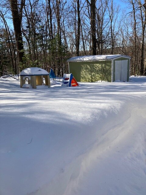
-
OBS/DISCO - The Historic James Blizzard of 2022
ORH_wxman replied to TalcottWx's topic in New England
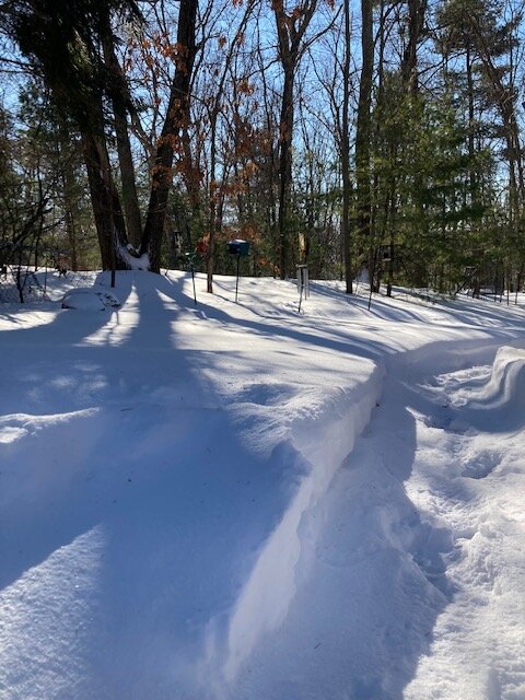
Trees do help a lot. I’ve noticed that where I live too. Snow seems much more evenly distributed with all the woods around me versus my old place which was not a ton of trees. The trees act as a wind break. -
OBS/DISCO - The Historic James Blizzard of 2022
ORH_wxman replied to TalcottWx's topic in New England
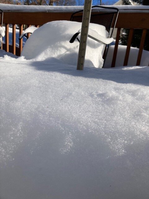
And TauntonBlizz posted a pic of him snow blowing that was pretty good evidence of 30”+. Snow on the level was comfortably over his 26” auger housing. -
OBS/DISCO - The Historic James Blizzard of 2022
ORH_wxman replied to TalcottWx's topic in New England
Yep. Bad run and over a 5 winter sample, pretty easy to happen. -
OBS/DISCO - The Historic James Blizzard of 2022
ORH_wxman replied to TalcottWx's topic in New England
That band was friggin awesome. It was like a lake effect streamer for a while. Grabbed an extra 3-4” of pure arctic fluff in about 2-3 hours. -
OBS/DISCO - The Historic James Blizzard of 2022
ORH_wxman replied to TalcottWx's topic in New England
The end is near now. You can tell we’re on the western side of it and it’s also weakening a little to boot. Vis up substantially in the last 5 min. -
OBS/DISCO - The Historic James Blizzard of 2022
ORH_wxman replied to TalcottWx's topic in New England
I echo this sentiment. Awesome storm for the UUU crowd and NeonPeon. Having young kids myself, I really appreciate the snowfalls more since I get to watch them go crazy in it. -
OBS/DISCO - The Historic James Blizzard of 2022
ORH_wxman replied to TalcottWx's topic in New England
Oh yeah. Right there near intersection of 290 and 495. I used to go there all the time to an old driving range near the Solomon Pond Mall. I think they closed it down years ago though. -
OBS/DISCO - The Historic James Blizzard of 2022
ORH_wxman replied to TalcottWx's topic in New England
What town is he again? I remember y out said he was just a bit east of ORH.

