ORH_wxman
-
Posts
90,902 -
Joined
-
Last visited
Content Type
Profiles
Blogs
Forums
American Weather
Media Demo
Store
Gallery
Everything posted by ORH_wxman
-
Pretty ripe pack now....looks like about 6-8" OTG eyeballing right now.
-
Ukie and GGEM have it today....GFS was a close miss. We'll see if Euro bites.
-
If it can set up a barrier jet, then its off to the races...it will rip down the coastal plain at like 15+ knots...gotta get it there first though.
-
High stakes forecast in the BOS-ORH corridor.....the timing of the flip is literally during the heaviest precip of the storm. A couple hours could make difference of like 0.40" of QPF.
-
Congrats the on the CJ
-
There is significant timing of the wave itself too....some of those frigid members shut the precip off in early afternoon while the warmer ones might delay the cold, but they are precipitating well into afternoon and even evening.
-

-
Some of these mesos at 12z are obscenely frigid tomorrow AM. This is going to be an interesting nowcast....because while model bias may be to cool the midlevels too quick, the surface/BL is a different story. The typical bias on model guidance is to cool too slowly when you have a meso-low out east....particularly if a weak barrier jet forms over SW ME and SE NH and then that will just rip right down the corridor east of ORH hills.
-
Next week is a classic Tip warm bum-bums in the car type of week....atmosphere is cold enough to support snow but getting into 2nd week of February means if its sunny, it will feel pretty warm when you don't have a fresh airmass in place. Those are the type of days that are like 41/9 for the rad pits that have snow cover.
-
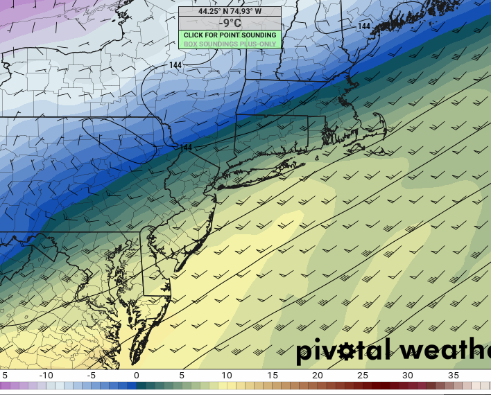
That's probably pure sleet with pixie dust mixed in....the cold layer is -10C on that which can actually form dendrites and the warm layer looks +3C-ish.....in addition the cold layer is really deep.
-
HRRR definitely cooled off. That's a lot of frozen precip here between 12z and 18z tomorrow AM....like 0.80" melted.
-
Looks like a scalping here Friday morning. Meh…hopefully we can flip to a burst of snow at the end.l for a quick inch to freshen things up.
-
GFS has a lot of frozen QPF in MA. Like around an inch here. It’s pretty remarkable the differences still.
-
Yeah it looks active on that look. It could change of course, but I’m betting we see a few legit chances during the Feb 10-20 period.
-
I supposed it’s possible. But these tend to have pesky warm layers aloft that prolong the sleet. If you get another tick colder on the 00z run then the snow would be looking a lot better in SNH.
-
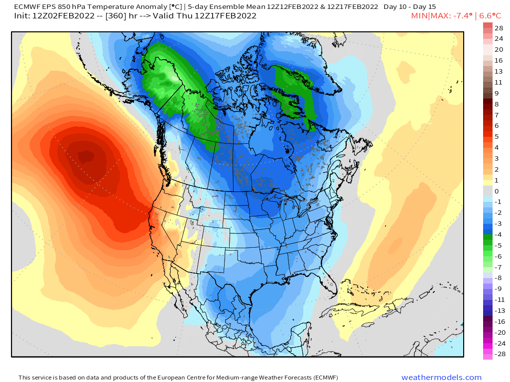
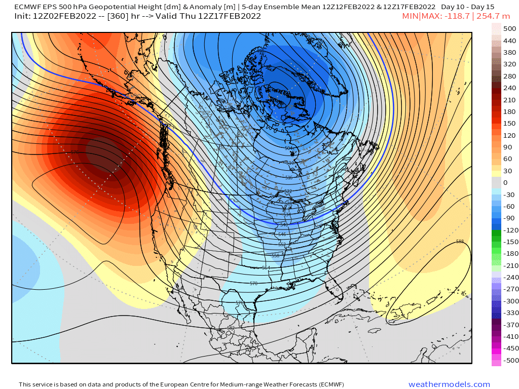
EPS looking pretty cold for mid-February. (5 day mean Feb 12-17)


-
But man, that is a pelletfest for about 4-5 hours here on Friday morning. During heavy precip too.
-
Nice little snow burst on the back end this run for the pike region.
-
That's a close call...the warm layer is also pretty fat on that and approaching 5C...gets hard to refreeze into pellets when that happens.....BUT, the cold layer is REALLY cold. It is even harder to NOT refreeze into pellets when your cold layer is -8C. Typically when the cold layer gets to -6C or so, ZR becomes difficult unless the -6C layer is right near the ground, which in this case it is not. So I'd prob say that is a sleet sounding....though maybe sort of a mix of sleet and ZR is possible too, but I'd be surprised if that was mostly ZR.
-
No, prob shifted north now...maybe N CT to S MA...but it's also possible it just never really materializes....if 900-925 hugs the below-freezing sfc air pretty close, then it will just be a brief period of ZR and then pellets (or a mix of both which will also cut down on accretion) and then mostly rain south of where that line slows down.
-
I'm selling big ice....seems the 900-925 layer cools very quickly behind the surface....that says pellets to me. I want to see the atmospheric profile more sloped for ice. There will be a narrow area of decent glaze, but it likely won't be crippling.
-
Ptype map on pivotal is trying to show ZR on Friday morning but it looks more like pellets...that's cold at 925 (-5ish) after 15z.
-
Ukie has a nice snower for 2/7-8 but no other support at the moment.
-
Maybe he wants temps and not dewpoints....here's temps
-
Yes, I did mention that....and we often see late shifts north on these. The most "interesting" aspect of the storm in SNE is now all about the frontal boundary at the surface.....if we meso-low this thing with a finger of low pressure over the Cape and into the waters east of BOS, then it's going to be a lot of icing (sleet may cut down though?)..