

ORH_wxman
-
Posts
90,902 -
Joined
-
Last visited
Content Type
Profiles
Blogs
Forums
American Weather
Media Demo
Store
Gallery
Everything posted by ORH_wxman
-
Yeah that is part of the reason this has a lower ceiling than a 2010-esque event. I remember that one had saturation up to like 500mb.
-
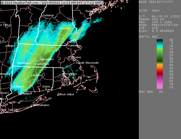
Looks pretty decent on radar with the light band. Gotta be some moderate in that
-
Yeah the sleet tickles up to near MA border and then collapses back south with a bit of a secondary with another 6 hour burst. Man, almost everything went right during that 3 week stretch. Funny to say almost because we actually whiffed on a couple that just missed us east like 1/31/15…I think that one got downeast Maine hard.
-
Ukie and GGEM aren’t buying the GFS suppression for next Friday and neither am I.
-
We prob want this south right now given other guidance.
-
Oops didn’t see Seymour’s squall thread. I’ll move the talk over there
-
I think some areas in N CT had 4-5” in that one. I think even BDL in the valley cleaned up.
-
Not really. The 20+ dbz echoes initially hit ORH around 505pm and then don’t clear out until 540ish. That’s a long time under 20+ dbz echoes in that unstable environment. I remember the event very well. We had about 3.5” in 35-40 minutes along with a flash freeze.
-
Yeah that squall line even on the robust HRRR is so narrow. The 2010 event was like 5x as wide. It was like 20+ miles wide. If it verifies that narrow then it’s going to be like 5-7 minutes and then done instead of 30+ minutes like we saw in a 2010 event. 5-7 minutes can still cause major road issues if it’s 4-5” per hour stuff, but you’d still end up with under an inch.
-
I wonder why they don’t supplement this with actual obs from first order sites. It has BOS at 31” when they are actually over 40”.
-
Antecedent airmass is better than 2/4. But this could definitely still be mostly sleet and ZR if it is amped enough. My gut says more snow than 2/4 but this is still 6 days out so really anything is on the table.
-
Most guidance had a band of lighter snow out ahead of the squalls.
-
Euro was a big thump for pike region northward. These solutions don’t really matter that much though at 6+ days out.
-
Yeah that looked good on 18z GFS. I’d like to see the vort track just a little further east though like more over PIT/CLE. Otherwise we risk getting a more shredded precip shield.
-
Yes....well not 70, but prob easily cracking 60.
-
Yeah they were always too amped on coastals....but they did WINDEX well. They were also good in icing events...prob mostly due to better resolution than most other guidance back then....I doubt they'd beat out the current hi res stuff in CAD nowadays.
-
The old RSM members on the SREF were excellent in WINDEX events too. Too bad we still can't have them around for winter.
-
It was the 1/28/10 event.
-
EPS is actually reloading the EPO at the end of the run too....we might be in that pattern for a while...maybe through mid-March, but we'll see if future runs break it down faster. The LR hasn't been very accurate this year.
-
It's hard to have a crap pattern with 200+ DM anomalies at H5 over Yukon/NW territories. If you keep shifting the ridge westward over the Bering Strait and then shove a deep trough into the four corners, then I'd be a little more concerned.
-
Ridge is def further east on this EPS run for the pattern post-2/25. Then it retrogrades a bit back but into an excellent position still and it's associated with split flow.
-
It's a week out....meaningless at this point. But the pattern def favors a colder type overrunning storm with that monster EPO ridge displaced a bit east which is supporting a monster 1040+ high over Ontario/Quebec.
-
Can't buy one all winter. Maybe this is the one.
-
Why are you posting a 153 hour CMC map? That event isn't until like 174-180h, lol.


