

ORH_wxman
-
Posts
90,902 -
Joined
-
Last visited
Content Type
Profiles
Blogs
Forums
American Weather
Media Demo
Store
Gallery
Everything posted by ORH_wxman
-
Winter storm for the 25th of February is imminent.
ORH_wxman replied to Typhoon Tip's topic in New England
Depends how deep the omega is on these. Sometimes you get monster omega punching up into 500mb and you get good snow growth anyway (ala 12/16/07) but most of the time these have crappier snowgrowth. It’ll be heavy baking powder for several hours which is good for base building but not great for maximizing accumulations. This could also trend another 75-100 miles north so that most of SNE ends up with 2-4” before the flip…that’s another possibility. -
Winter storm for the 25th of February is imminent.
ORH_wxman replied to Typhoon Tip's topic in New England
My guess is sleet will def make it to at least the MA/NH border. You aren’t tracking that vort through central NY and keeping sleet line south of the pike. That doesn’t mean no big thump before that though. The thump looks very strong right now on most guidance. -
The GYX to ORH axis (including Rays area) has taken it on the chin this winter. Kind of due for a few snow bombs that hit 15+ miles inland.
-
Winter storm for the 25th of February is imminent.
ORH_wxman replied to Typhoon Tip's topic in New England
It did this in the Feb 4th system. It eventually caved at lest partway. -
Sorry to hear my friend. Hopefully the new place is good to you. Maybe we can get one more big dog before this season is over.
-
Winter storm for the 25th of February is imminent.
ORH_wxman replied to Typhoon Tip's topic in New England
You proudly flaunt your IPA affinity. Nothing wrong with that or the edibles. I don’t personally care, lol. I just noticed you were making more and more posts about it recently. Though the “Friday is gone” post did cause some of us to be concerned maybe you had consumed 3 or 4 IPAs instead of the usual one or two before passing out. -
Winter storm for the 25th of February is imminent.
ORH_wxman replied to Typhoon Tip's topic in New England
Yeah I’m selling GFS. This pattern wants to track the vort well west and typically that is going to hint where the trends will happen. Even the GFS is tracking the vort from about Erie PA to CNE. That’s not typically going to stay all snow south of the pike. -
Winter storm for the 25th of February is imminent.
ORH_wxman replied to Typhoon Tip's topic in New England
You are becoming obsessed with his weed usage. It’s prob 10x healthier than beer. -
Luckily for the ski areas, the pattern setting up after Wednesday’s torch is one where NNE can rebuild some base and maintain it. It will be a cold pattern…not one of those “we got 6” of feathers and it was 38 degrees and sunny two days later so it all evaporated” type patterns. I’d honestly be kind of surprised if NNE doesn’t clean up the next 3 weeks based on ensemble guidance. Of course, this winter has found ways to disappoint so a screw job wouldn’t be a total shock but it would still be something that’s low probability to me. Esp up there.
-
Easiest way to get there for you is prob something like 10” to close out February next week and then a 50 spot in March and a 30 spot in April. 50 inches in March there is prob not THAT anomalous. I’d bet it’s like 1 sigma above normal.
-
Winter storm for the 25th of February is imminent.
ORH_wxman replied to Typhoon Tip's topic in New England
Prob more of a sleet bomb there. -
Winter storm for the 25th of February is imminent.
ORH_wxman replied to Typhoon Tip's topic in New England
Yeah I actually think he’s a solid tv met here. But they all kind of have to play up “nice” weather and torches…esp during the cold season when most normal people hate the cold and snow. Only sickos like us want it. Though up in your neck of the woods it’s a little more balanced because a lot of the economy is driven by winter sports in the cold season. -
Yeah the only question is how much western troughing there is underneath the EPO blocking…we obviously don’t want too much or you get cutter city…but one good thing in this pattern is the +NAO is actually not that bad….it’s a monster vortex displaced a bit southwest so it actually might produce a lot of confluence in Quebec….we had that in December 2007 which helped it be such a prolific month in New England despite a lot of western troughing.
-
We probably need to start a March thread but it’s an impressive pattern out at the end of the ensembles.
-
Winter storm for the 25th of February is imminent.
ORH_wxman replied to Typhoon Tip's topic in New England
This run definitely had a healthier thump than 00z. I don’t care if it’s warmer aloft if it’s producing better precip on the front end. I’d rather 8” and then sleet/ZR than staying all snow with the same amount. I’d be surprised if we stayed all snow in this unless the whole vort track trends about 75-100 miles south of current guidance. But the key is having that front end WCB with a bent back WF to produce. Sometimes, you get a more shredded precip look on the front end and you’re done after 2-4” even if the profile is colder initially…12/16/07 is a good example against some system like 1/28/09 or 1/11/09…the latter two had better antecedent airmasses but the former produced more snow because we really ripped on the front end. -
Yeah euro says we do another one on 2/27.
-
Winter storm for the 25th of February is imminent.
ORH_wxman replied to Typhoon Tip's topic in New England
Great run for many. Solid snows N of MA/CT border and plenty of sleet and ZR for Kevin which is what he was hoping for. -
Winter storm for the 25th of February is imminent.
ORH_wxman replied to Typhoon Tip's topic in New England
Canadian held serve and Ukie took a good bump north too. -
I know. He wants someone to respond telling him it will snow more there than he says. But nobody actually knows how this will trend 5 days out. History and the SE ridge in place says my bet is it trends north, but there’s other factors that could mute that so it wouldn’t be utterly shocking to me if it doesn’t trend north. Probabilistic forecasting is the way to go here.
-
There’s plenty of SWFEs that have given you warning snows. I’d def favor north right now but speaking in absolutes is pretty silly at D5.
-
Not nearly the meat grinder in place as there was in that pattern.
-
As someone who lives in the pike region, I’ll be hoping for some southerly ticks today because these come north more often than not once inside of 84 hours.
-
What in the hell are you talking about? Nothing has changed on Friday for like 3 days.
-
Looks pretty good for N ORH county
-
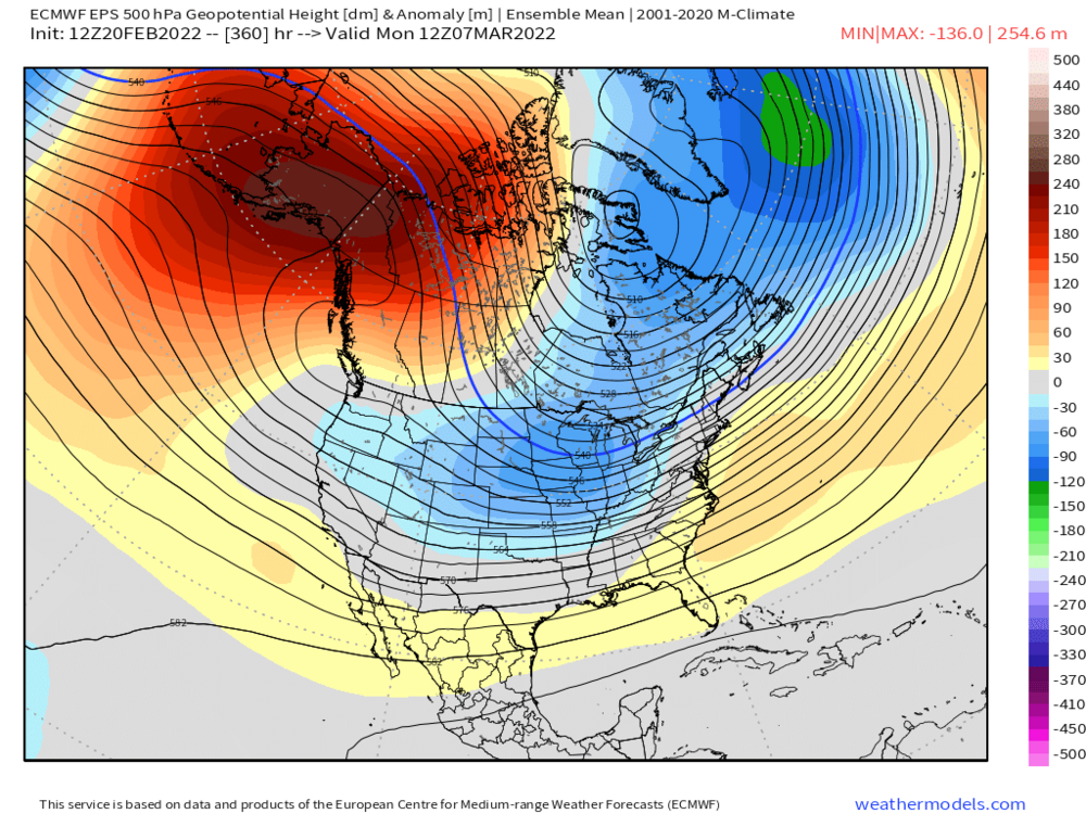
+300 DM anomaly at H5 over the EPO region on the 360h EPS today. That is crazy.


