

ORH_wxman
-
Posts
90,902 -
Joined
-
Last visited
Content Type
Profiles
Blogs
Forums
American Weather
Media Demo
Store
Gallery
Everything posted by ORH_wxman
-
Winter storm for the 25th of February is imminent.
ORH_wxman replied to Typhoon Tip's topic in New England
IJD is a bit of a snow hole because warm air from the south gets in there unimpeded and it can get a bit of downsloping on an east or northeast wind. It’s not the worst spot in CT but usually most of the towns to your north/northeast/west will do better. I remember the storm you are talking about though last year…I think it was the super bowl Sunday storm on 2/7/21. That awesome band smoked your area. -
Winter storm for the 25th of February is imminent.
ORH_wxman replied to Typhoon Tip's topic in New England
Just need some pics of your kids playing in 12”+ Friday evening while puffy 30 to 1 CJ dendrites fall on a light northeast wind as you are snow blowing the driveway. -
Winter storm for the 25th of February is imminent.
ORH_wxman replied to Typhoon Tip's topic in New England
In all seriousness, you at least aren’t gonna get screwed in this one. Jackpot or not….you’re a lock for 8-12” with some upside for 12-16 if you can get into that quasi-stationary banding Friday morning/midday. -
Winter storm for the 25th of February is imminent.
ORH_wxman replied to Typhoon Tip's topic in New England
He’ll get like 9-10” with round 1 and then the evening CJ/IVT will give him another 3” of currier and Ives jspin fluff and it will allow him to beat Ray by 0.2” and then Ray will have a huge meltdown. -
Winter storm for the 25th of February is imminent.
ORH_wxman replied to Typhoon Tip's topic in New England
Looks slightly colder than 12z. But almost the same. Noise. -
Yeah it would favor those type of threats. Cutters are a definite risk too.
-
Winter storm for the 25th of February is imminent.
ORH_wxman replied to Typhoon Tip's topic in New England
Yeah I wouldn't change any forecasts yet unless I was on the low side already....if 00z comes in similar to these non-NAM solutions, then I'm probably going to up my expectation to like 8-14" for the pike region. Right now, I'm kind of thinking more like 5-10. -
Winter storm for the 25th of February is imminent.
ORH_wxman replied to Typhoon Tip's topic in New England
18z Deutschmark went south/colder too to round out the JV suite. -
Winter storm for the 25th of February is imminent.
ORH_wxman replied to Typhoon Tip's topic in New England
This is the furthest north that run gets with the sleet line....I'm skeptical but that's kind of like the Euro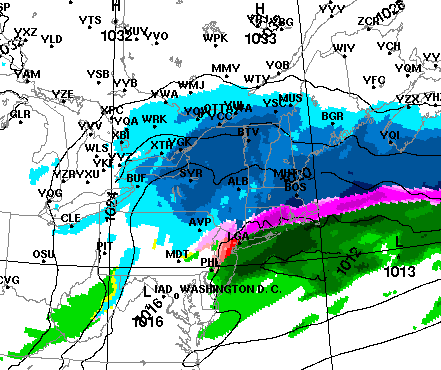
-
Winter storm for the 25th of February is imminent.
ORH_wxman replied to Typhoon Tip's topic in New England
18z Reggie went another tick colder. Here's 12z Friday: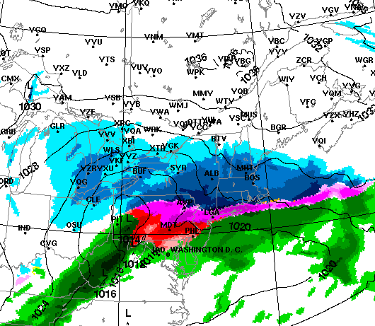
-
Winter storm for the 25th of February is imminent.
ORH_wxman replied to Typhoon Tip's topic in New England
I wouldn't be surprised if the NAM comes south at 00z and the other guidance comes north to narrow the goalposts. Other guidance is so much colder/south than the NAM that at some point we're going to need to see a convergence. -
Winter storm for the 25th of February is imminent.
ORH_wxman replied to Typhoon Tip's topic in New England
Yeah it went south and is still the warmest....tells you how much of an outlier it was at 12z. I'll bet it comes south again at 00z. -
Yeah between now and the first couple days of March, there's a couple pulses of western ridging that might help aid any diving shortwaves....after that, we get more western troughing. Too bad we couldn't keep the 2015-esque look out there that guidance had last week....but we knew that probably wasn't verifying. The monster EPO block isn't going anywhere though so we're going to continue to have winter threats right into mid-March most likely.
-
Winter storm for the 25th of February is imminent.
ORH_wxman replied to Typhoon Tip's topic in New England
18z NAM coming in with stronger confluence....shocker I know. -
Winter storm for the 25th of February is imminent.
ORH_wxman replied to Typhoon Tip's topic in New England
Then the jackpot zone would prob shift to like metro-west along 128 down into N RI just on the cold side of the CF and you can add 2-4" to your totals in N CT. -
Winter storm for the 25th of February is imminent.
ORH_wxman replied to Typhoon Tip's topic in New England
Yeah there is going to be some CF enhancement on this storm too....The combo of CF enhancement and wherever the mid-level WF slows down and starts to slide east is where they could get smoked...like a 12-16" spot....and right now the best spot for that looks like NE MA and SE NH....maybe back down 495 to near ORH assuming we don't see any northward ticks. -
Winter storm for the 25th of February is imminent.
ORH_wxman replied to Typhoon Tip's topic in New England
I honestly am not sure where Ray would rather be right now for this event....I would definitely trade the pike region for NH border region in this. Does it mean NH border will jackpot? No, that could happen 20 miles north or 20 miles south, we don't know yet, but they are the most locked-in for warning snows out of any spot. I could still taint enough to only get 4-6" whereas that isn't going to happen up there and a tick south doesn't take them out of 8-10" amounts whereas it might take CON out of them. Ray's area probably has the most wiggle room in both directions. Jackpots aren't easy to get...so nobody should ever expect them. But being in a relatively "Stress-free" zone for solid warning snows is about as good as you can expect 48 hours before an overrunning event. -
Winter storm for the 25th of February is imminent.
ORH_wxman replied to Typhoon Tip's topic in New England
George is in Foxborough -
Winter storm for the 25th of February is imminent.
ORH_wxman replied to Typhoon Tip's topic in New England
Chris (Oceanstatewx) and I were discussing yesterday that this one will likely have a stripe of 12-15" somewhere because as the bent back mid-level WF progresses north, it encounters so much resistance that it starts sliding east and where that happens is where a zone sees quasi-stationary banding for 4-6 hours and that will be enough to turn the usual 6-10" into a 10-15" jackpot zone. -
Winter storm for the 25th of February is imminent.
ORH_wxman replied to Typhoon Tip's topic in New England

-
Winter storm for the 25th of February is imminent.
ORH_wxman replied to Typhoon Tip's topic in New England
May have to bump this one Friday evening.... -
Winter storm for the 25th of February is imminent.
ORH_wxman replied to Typhoon Tip's topic in New England
There's also a nice ~600mb sig that is up into upstate NY over to central/northern VT and into Phin/Alex land....I bet there will be a band up there too that isn't really visible on the QPF maps. -
Winter storm for the 25th of February is imminent.
ORH_wxman replied to Typhoon Tip's topic in New England
Yes....I expect a little nudge back north too.....I'd be surprised if the storm verified as cold as the 12z Euro....but it's good to see a south tick to give some wiggle room for when that north nudge happens. -
Winter storm for the 25th of February is imminent.
ORH_wxman replied to Typhoon Tip's topic in New England
Anything meaningful should be done by mid to late afternoon Friday there....might be some lingering light snows into evening but the meat of the event is over after 18z. -
Winter storm for the 25th of February is imminent.
ORH_wxman replied to Typhoon Tip's topic in New England
Lot of confluence up north....difficult to trend it hard north when you have a 1040 high sitting over Ottawa the night before. It's not like one of those SWFE's where the high is trying to hold on in Nova Scotia as the storm gets going.


