

ORH_wxman
-
Posts
90,902 -
Joined
-
Last visited
Content Type
Profiles
Blogs
Forums
American Weather
Media Demo
Store
Gallery
Everything posted by ORH_wxman
-
Winter storm for the 25th of February is imminent.
ORH_wxman replied to Typhoon Tip's topic in New England
Yeah....that thump is really good here. Most of our snow is from 4am to 10am....so it's important that it slams during that time before we dryslot. -
Winter storm for the 25th of February is imminent.
ORH_wxman replied to Typhoon Tip's topic in New England
Yes, I think this is actually a pretty good map. I might bring the "uncertain" dotted line up into the BOS-ORH zone too, but that's nitpicking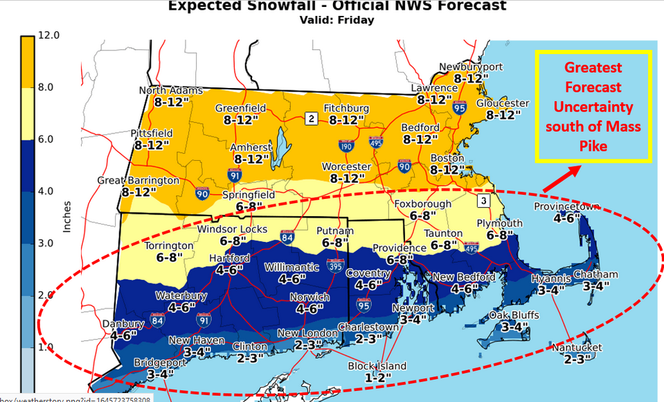
-
Winter storm for the 25th of February is imminent.
ORH_wxman replied to Typhoon Tip's topic in New England
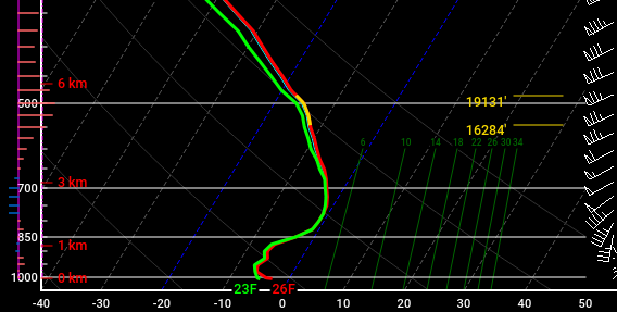
Well you chose the 24h sounding....at 12z tomorrow. Most guidance has you pinging by then so the GFS is cold. Here's the 3km NAM sounding at 2am for you....notice how its marginal and perhaps could be sleet: Now here's the sounding 2 hour later at 4am....notice how it has cooled a bit as the lift in the DGZ looks much stronger and the precip gets heavier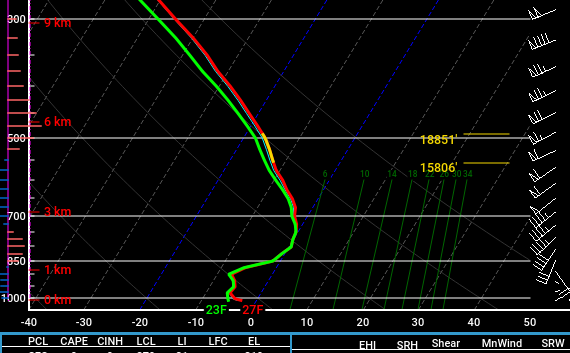
-
Winter storm for the 25th of February is imminent.
ORH_wxman replied to Typhoon Tip's topic in New England
You guys in SW CT might start as straight sleet but then flip to moderate/heavy snow for a few hours as the lift deepens and cools the marginal warm layer, before it finally gets overwhelmed by WAA. -
Winter storm for the 25th of February is imminent.
ORH_wxman replied to Typhoon Tip's topic in New England
No it won't mix that much there....it might ping as the precip starts getting lighter near midday, but the damage is done by then....decent chance you don't mix at all. -
Winter storm for the 25th of February is imminent.
ORH_wxman replied to Typhoon Tip's topic in New England
Looked awesome for pike up to S NH....I'm expecting to ping though even though GFS says it stays south. But just need to hold off the pingers until about 15z and we're locked for solid warning snows. -
Yeah the ensmebles have a bit of reload....so for a few days, the cold in Canada looks a bit drained and gives the impression that winter threats are over. But once the reload happens....you can see how Canada cold reloads too....see animation below on the T850 anomalies....I started the loop at 192 hours when Canada is kind of drained of big cold and watch how it reloads:
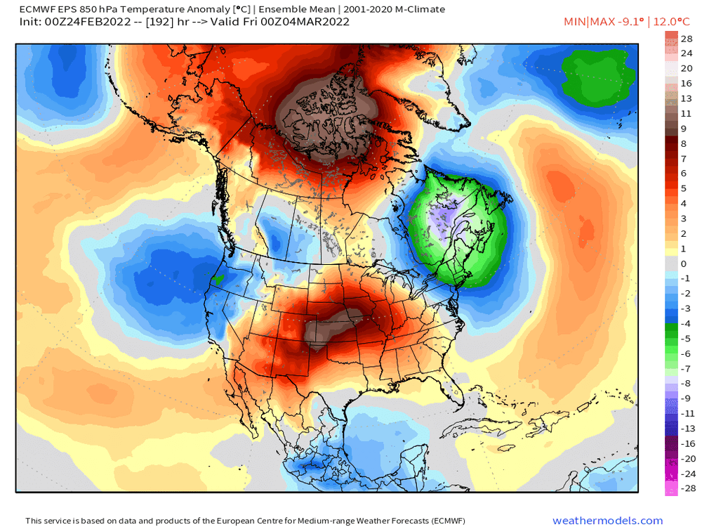
-
Winter storm for the 25th of February is imminent.
ORH_wxman replied to Typhoon Tip's topic in New England
FV3 is garbage....useless in this setup until they fix its bad cold bias. -
Winter storm for the 25th of February is imminent.
ORH_wxman replied to Typhoon Tip's topic in New England
Almost dead nuts with 06z. Might have been like 4 miles north, lol -
Winter storm for the 25th of February is imminent.
ORH_wxman replied to Typhoon Tip's topic in New England
You never had a shot down there. -
Winter storm for the 25th of February is imminent.
ORH_wxman replied to Typhoon Tip's topic in New England
Yeah, I've been saying that zone for days? Lol....not sure why you are making it sound like I was previously disagreeing with you. -
Winter storm for the 25th of February is imminent.
ORH_wxman replied to Typhoon Tip's topic in New England
They will occur where the QS banding starts slowing down and sliding east....wherever that occurs is where the 12"+ amounts happens. Best guess is S VT to S NH...but it could be into N MA too. -
Winter storm for the 25th of February is imminent.
ORH_wxman replied to Typhoon Tip's topic in New England
It is still tracking the vort north of the Euro and some other guidance....the 12z run is tracking it over northern Lake Ontario. While others are more like BUF to ROC . It's not a massive difference but that 25-30 miles matters when we're talking about areas that are flirting with the sleet line. -
Winter storm for the 25th of February is imminent.
ORH_wxman replied to Typhoon Tip's topic in New England
We didn't get more snow along the pike than 06z because the QPF was pretty weak sauce this run compared to previous. QPF is under an inch for us through 21z tomorrow on the 12z run. -
Winter storm for the 25th of February is imminent.
ORH_wxman replied to Typhoon Tip's topic in New England
Def colder than 06z though...06z gave almost no snow south of HFD, now the 12z gives advisory snows down there. -
Winter storm for the 25th of February is imminent.
ORH_wxman replied to Typhoon Tip's topic in New England
12z NAM tickling colder through 21 hours. Heavy snow down in parts of S CT at 09z while the previous run was scalping them. -
Winter storm for the 25th of February is imminent.
ORH_wxman replied to Typhoon Tip's topic in New England
Yeah the CF will def be most pronounced in SE NH or S ME....but that isn't the only factor in the best snowfall...you want to overlap that with the strongest fronto banding....the fronto banding is a little stronger south and it weakens some as it goes north into S ME. So I'm picking your area to S NH to get the best of both worlds (longest exposure to good fronto banding while getting CF enhancement at the same time) -
Winter storm for the 25th of February is imminent.
ORH_wxman replied to Typhoon Tip's topic in New England
There will be 12"+ totals....this is not skimpy on QPF. Most likely spot is prob S NH/S VT and N MA near the border and maybe into far S ME where they get into quasi-stationary banding for a while while those of us to the south are dryslotted for a time. -
Winter storm for the 25th of February is imminent.
ORH_wxman replied to Typhoon Tip's topic in New England
HRRR looks a little colder than 06z through 24 hours -
Winter storm for the 25th of February is imminent.
ORH_wxman replied to Typhoon Tip's topic in New England
Almost every model has it mostly done by 18z unless you are up by Ray…then round 2 starts sinking south and filling in late afternoon. -
Winter storm for the 25th of February is imminent.
ORH_wxman replied to Typhoon Tip's topic in New England
06z euro is prob in the middle of guidance right now. NAM is still the warmest by a decent amount though the gap isn’t nearly as much as 12z yesterday when it was actually failing to give Ray warning snows. -
Winter storm for the 25th of February is imminent.
ORH_wxman replied to Typhoon Tip's topic in New England
Clearly no coordination between ALY and BOX since one office tossed the NAM and the other is buying it. -
Winter storm for the 25th of February is imminent.
ORH_wxman replied to Typhoon Tip's topic in New England
Btw, I watched him too. Amazing how much energy he still has. You can tell he still gets excited for these higher impact snow events. Lol. Hopefully he goes another couple winters before hanging them up…all time great. First ballot HOFer. -
Winter storm for the 25th of February is imminent.
ORH_wxman replied to Typhoon Tip's topic in New England
He will probably peak at the 00z NAM to make sure it comes south a little more and then update the map for the 11pm segment. -
Winter storm for the 25th of February is imminent.
ORH_wxman replied to Typhoon Tip's topic in New England
It’s because they don’t forecast for NH. They are using the GYX forecast for the NH amounts. I would assume they coordinate more with GYX on the border region before they issue a more final map.


