ORH_wxman
-
Posts
93,093 -
Joined
-
Last visited
Content Type
Profiles
Blogs
Forums
American Weather
Media Demo
Store
Gallery
Everything posted by ORH_wxman
-
Possible coastal storm centered on Feb 1 2026.
ORH_wxman replied to Typhoon Tip's topic in New England
It is also a low probability to even have a major threat less than a week after a biggie. But here we are....whether it hits or not. -
Possible coastal storm centered on Feb 1 2026.
ORH_wxman replied to Typhoon Tip's topic in New England
Ukie is a whiff again, but slightly better aloft. -
Possible coastal storm centered on Feb 1 2026.
ORH_wxman replied to Typhoon Tip's topic in New England
Late surge this run NW -
Possible coastal storm centered on Feb 1 2026.
ORH_wxman replied to Typhoon Tip's topic in New England
OP GFS gonna be east too. -
Possible coastal storm centered on Feb 1 2026.
ORH_wxman replied to Typhoon Tip's topic in New England
RGEM looked pretty good at 84... -
Possible coastal storm centered on Feb 1 2026.
ORH_wxman replied to Typhoon Tip's topic in New England
NAM would prob still get eastern areas I think…but I’m not gonna spend more than about 30 seconds extrapolating the 84h NAM. -
Possible coastal storm centered on Feb 1 2026.
ORH_wxman replied to Typhoon Tip's topic in New England
No the storm could still track closer but it’s not going to be via that route. It would likely be pulled almost due north on a closer track…we could track it from east of HSE up near the BM and that would probably spread decent snows back to the valley. -
Possible coastal storm centered on Feb 1 2026.
ORH_wxman replied to Typhoon Tip's topic in New England
Yeah…i mean I’d love for that low to track from interior NC to inside the BM, lol…but that’s not happening in this setup. -
I remember when he saw no shadow in 2013…I think we had like 75” of snow after that point. The smart pick though is for him to see his shadow. He sees it most years.
-
Possible coastal storm centered on Feb 1 2026.
ORH_wxman replied to Typhoon Tip's topic in New England
That’s not the actual low track…not sure why it’s depicted that way. The low actually starts off the coast of Savannah (after a weak vestige near FL panhandle 12 hours earlier) It’s not over interior NC and moving northeast. -
Possible coastal storm centered on Feb 1 2026.
ORH_wxman replied to Typhoon Tip's topic in New England
Half of the MBTA trains stopped working that winter. It was a disaster commuting on the train into Boston. I had my office in the seaport that winter. Seaport was prob ground zero though, lol. I remember that one mesoscale event in mid-February (not the 2/15 storm) where there was this very narrow band of snow hugging the coast. Like back bay was sunny I think and when we got to south station, it was almost a whiteout. They had like 3-4” of feathers on the seaport. -
Possible coastal storm centered on Feb 1 2026.
ORH_wxman replied to Typhoon Tip's topic in New England
CFS? Lol. Surprised Ant didn’t pull out the Korean. -
Possible coastal storm centered on Feb 1 2026.
ORH_wxman replied to Typhoon Tip's topic in New England
AI hasn’t been as consistent as last couple threats. They kind of locked in pretty early on those. Sometimes they’ve shown a hit in this and other times it’s a cape scraper. -
Possible coastal storm centered on Feb 1 2026.
ORH_wxman replied to Typhoon Tip's topic in New England
Well if we only looked at GEFS and EPS, we’d predict a big hit for eastern areas. -
March 1960 was pretty widespread but didn’t get quite as far south with the snow.
-
Possible coastal storm centered on Feb 1 2026.
ORH_wxman replied to Typhoon Tip's topic in New England
It’s the 84h NAM but that would likely extrapolate to a hit on some level. -
Possible coastal storm centered on Feb 1 2026.
ORH_wxman replied to Typhoon Tip's topic in New England
In my defense, my guess was correct. It was hidden down in the memory hole but not quite deep enough. -
Possible coastal storm centered on Feb 1 2026.
ORH_wxman replied to Typhoon Tip's topic in New England
He used to post here right? All of the sudden I can’t remember his handle…rainshadow? He was at Mt holly by that point. -
Possible coastal storm centered on Feb 1 2026.
ORH_wxman replied to Typhoon Tip's topic in New England
I have another analog https://www.meteo.psu.edu/ewall/NARR/1989/us0224.php#picture Ok, just had to get the childhood PTSD out of the way…I do think this one looks better than that one did. -
Possible coastal storm centered on Feb 1 2026.
ORH_wxman replied to Typhoon Tip's topic in New England
Would be nice to get the Euro suite on board. Need a 100 mile bump west on it. -
Possible coastal storm centered on Feb 1 2026.
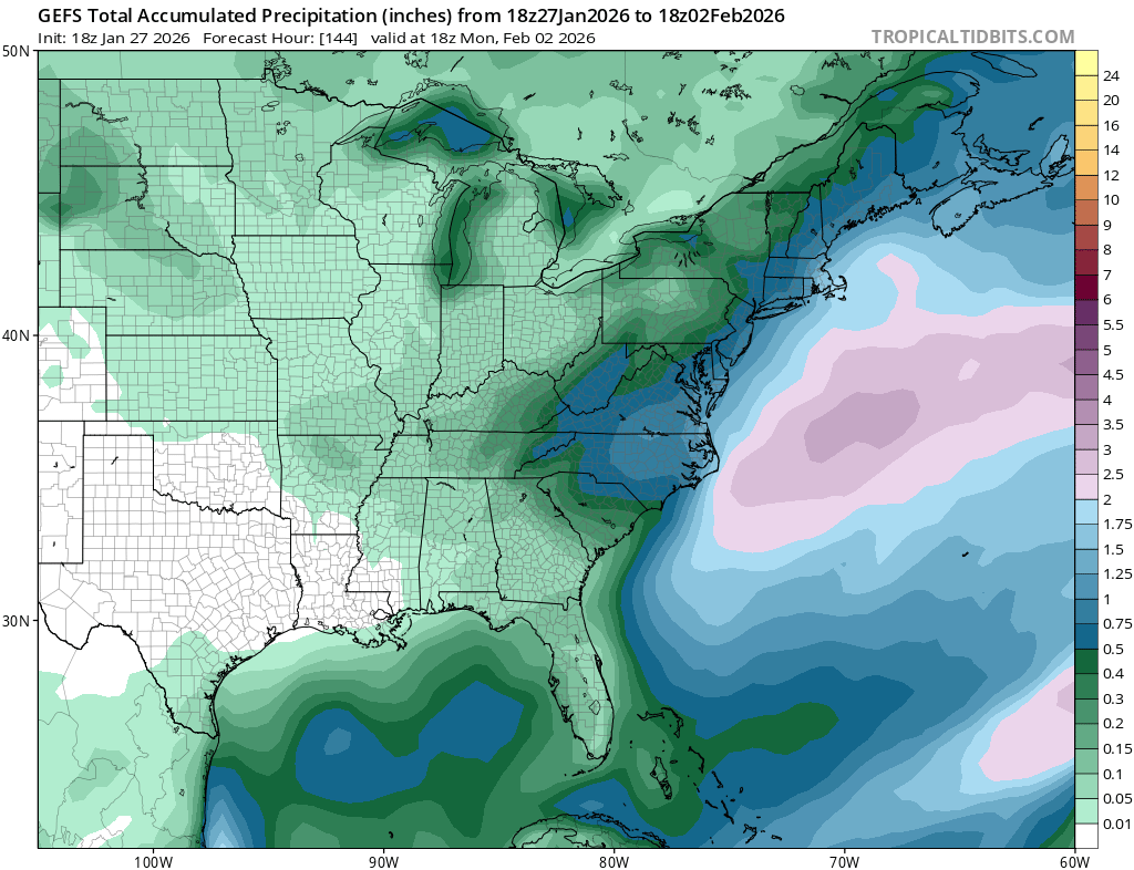
ORH_wxman replied to Typhoon Tip's topic in New England
GEFS mean is a huge storm for eastern folks and a moderate storm even for western NE. Edit: 4seasons beat me to it
-
Possible coastal storm centered on Feb 1 2026.
ORH_wxman replied to Typhoon Tip's topic in New England
Someone needs to AI a pic of Scooter rounding up Wolf pelts. -
Yeah the new PNS looks better
-
The newer PNS is a total disaster. Can’t see dates and they only have times without AM/PM designation….but it honestly looks like they left a whole bunch of lower reports in there from yesterday before the storm was over. So many of those numbers don’t pass the smell test. They have exactly 2 totals over 20” in Middlesex county and a dozen sub-17” totals.
-
Possible coastal storm centered on Feb 1 2026.
ORH_wxman replied to Typhoon Tip's topic in New England
These trends are poor so far at 12z. Sans GFS. I guess is Euro comes west, we won’t care that much about the Ukie/GGEM.