

ORH_wxman
-
Posts
90,902 -
Joined
-
Last visited
Content Type
Profiles
Blogs
Forums
American Weather
Media Demo
Store
Gallery
Everything posted by ORH_wxman
-
March 12 Rain to…more rain? Maybe some snow
ORH_wxman replied to HoarfrostHubb's topic in New England
Prob would’ve been Dec 10, 2008 -
March 12 Rain to…more rain? Maybe some snow
ORH_wxman replied to HoarfrostHubb's topic in New England
Yep. These are the events Kevin can get terrain enhancement on. He needs a westerly component or a southerly component where he is. -
March 12 Rain to…more rain? Maybe some snow
ORH_wxman replied to HoarfrostHubb's topic in New England
Kuchera (not posting 10 to 1 in this)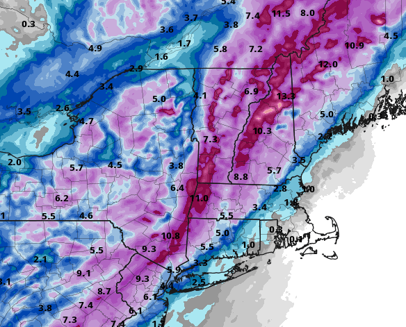
-
March 12 Rain to…more rain? Maybe some snow
ORH_wxman replied to HoarfrostHubb's topic in New England
3km is actually snowier for SNE and more potent with the dynamics than 12z. -
March 12 Rain to…more rain? Maybe some snow
ORH_wxman replied to HoarfrostHubb's topic in New England
Yeah the dynamics look much better on that run....hopefully it plays out with stronger dynamics. Weak and strung out it not going to be as fun....even if it might get 1.5" of slush on the weak scenario versus 0.7" on the stronger scenario. -
March 12 Rain to…more rain? Maybe some snow
ORH_wxman replied to HoarfrostHubb's topic in New England
18z NAM going west a solid tick. -
March 12 Rain to…more rain? Maybe some snow
ORH_wxman replied to HoarfrostHubb's topic in New England
Yes, and then a week later there was a marginal 8-10" storm for north of the pike....basically a front ender at 32-33F isothermal sounding. That was poorly forecasted. -
March 12 Rain to…more rain? Maybe some snow
ORH_wxman replied to HoarfrostHubb's topic in New England
There will be some good precip rates, but duration is an issue. This thing will be screaming northeast. -
March 12 Rain to…more rain? Maybe some snow
ORH_wxman replied to HoarfrostHubb's topic in New England
Around here I only really want to see about -5C or so which the top of the saturated layer achieves (at least on the western half of the sleet band)....there's so much salt nuclei in SNE sticking out into the ocean that the baseline numbers get skewed warmer for ice crystals. That said, my guess is the HRRR is too cold anyway, so it's prob a moot point.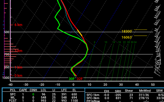
-
March 12 Rain to…more rain? Maybe some snow
ORH_wxman replied to HoarfrostHubb's topic in New England
Pivotal is probably too wide with the sleet ptype looking at the soundings. Like it's showing sleet where the entire column is colder than -2C but because it's not saturated in the DGZ, it shows up as sleet. -
March 12 Rain to…more rain? Maybe some snow
ORH_wxman replied to HoarfrostHubb's topic in New England
There was 1-2" in the interior on 3/3 -
March 12 Rain to…more rain? Maybe some snow
ORH_wxman replied to HoarfrostHubb's topic in New England
For us, yes....out west though it's been a much bigger differences on some of these runs. -
March 12 Rain to…more rain? Maybe some snow
ORH_wxman replied to HoarfrostHubb's topic in New England
All the 12z hi-res guidance seems pretty bullish on snow in SNE...esp central/west....GFS kind of meh, though it continues to trend east. -
March 12 Rain to…more rain? Maybe some snow
ORH_wxman replied to HoarfrostHubb's topic in New England
Yeah if you compare all the solutions from like 2 days ago, the Euro is taking most guidance to the woodshed in the means. Definitely a needed coup for that model. -
March 12 Rain to…more rain? Maybe some snow
ORH_wxman replied to HoarfrostHubb's topic in New England
They will be bad in the interior for sure...maybe even the coast if the snow rips for a couple hours. But these are always much tougher than a system like Wednesday. Prob a blend between the two....even Kuchera is prob a lot better in this setup. -
March 12 Rain to…more rain? Maybe some snow
ORH_wxman replied to HoarfrostHubb's topic in New England
Prob about 10 to 1? It was pretty fluffy in terms of snow growth but also a little pasty because the sfc was near freezing so they kind of offset eachother to be near 10 to 1. -
March 12 Rain to…more rain? Maybe some snow
ORH_wxman replied to HoarfrostHubb's topic in New England
They are going to be more accurate in this setup than the 10 to 1 clown maps you are posting -
March 12 Rain to…more rain? Maybe some snow
ORH_wxman replied to HoarfrostHubb's topic in New England
That’s almost warning snowfall for ORH and advisory even into eastern areas. -
March 12 Rain to…more rain? Maybe some snow
ORH_wxman replied to HoarfrostHubb's topic in New England
LOL 18z euro -
March 12 Rain to…more rain? Maybe some snow
ORH_wxman replied to HoarfrostHubb's topic in New England
3km NAM still trying to redevelop the low southward along the front later in the event to give a quick burst of moderate to heavy snow and crashing temps in SNE. -
March 12 Rain to…more rain? Maybe some snow
ORH_wxman replied to HoarfrostHubb's topic in New England
Greens to whites to SR/Sugarloaf crush job. -
March 12 Rain to…more rain? Maybe some snow
ORH_wxman replied to HoarfrostHubb's topic in New England
NAM def more amped than 12z. -
March 12 Rain to…more rain? Maybe some snow
ORH_wxman replied to HoarfrostHubb's topic in New England
Whole system was kind of meh from a dynamics standpoint...for a min i thought it was gonna try and go the 3km NAM route of redeveloping a nice low along the front further south, but it wasn't quite able to do that. It would still flip most people over to snow but prob not more than an inch or two once you are southeast of Berkshires/NW CT in SNE....it's a decent event for CNE/NNE but again, lacking the dynamics so it's not double digits. -
March 12 Rain to…more rain? Maybe some snow
ORH_wxman replied to HoarfrostHubb's topic in New England
Wow this run is going to be interesting,,.cold. -
March 12 Rain to…more rain? Maybe some snow
ORH_wxman replied to HoarfrostHubb's topic in New England
Absolutely, and someone living in DC would kill for Ray's 43" even though he's about ready to throw himself off the Tobin with that seasonal total. All about expectations. Anyways, not to derail too much....here's what we got for this threat: East basket: NAM/Euro/UKMET West Basket: GFS/ICON/RGEM In between: GGEM


