ORH_wxman
-
Posts
90,902 -
Joined
-
Last visited
Content Type
Profiles
Blogs
Forums
American Weather
Media Demo
Store
Gallery
Everything posted by ORH_wxman
-
March 2022 Obs/Disc: In Like a Lamb, Out Like a Butterfly
ORH_wxman replied to 40/70 Benchmark's topic in New England
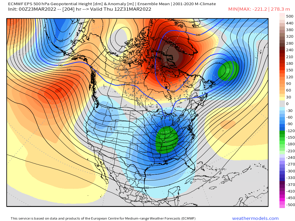
If you're trying to get a good late season snow event, best window on the EPS is for 3/31ish......the synoptic pieces are all there (big Davis Strait block, 50/50 low, and trough moving into the OH Valley)
-
March 2022 Obs/Disc: In Like a Lamb, Out Like a Butterfly
ORH_wxman replied to 40/70 Benchmark's topic in New England
He's been trying the Kevin reverse psych angle for like a week-plus now. If he keeps saying it will never happen, maybe it will? But yeah, even though this is a pretty good pattern coming up for a late season snow threat, you still need a lot to go right...esp down there. Not as hard for a place like ORH county or NW MA. Most will at least see flakes this weekend though under that ULL for Saturday/Sunday. -
March 2022 Obs/Disc: In Like a Lamb, Out Like a Butterfly
ORH_wxman replied to 40/70 Benchmark's topic in New England
It was later than that....pretty sure it was 4/12/13 -
March 2022 Obs/Disc: In Like a Lamb, Out Like a Butterfly
ORH_wxman replied to 40/70 Benchmark's topic in New England
Get ready for some bare ground and teens next week when walking out the door. At least in years like 2017 and 2018, I still had a deep snow pack at this point, so it wasn't all bad having cold....but I Agree this is probably the absolute worst. -
March 2022 Obs/Disc: In Like a Lamb, Out Like a Butterfly
ORH_wxman replied to 40/70 Benchmark's topic in New England
No it could absolutely deliver a winter threat. It’s below normal heights and below normal temps but you can easily get 38F rain on that in late March and early April. -
March 2022 Obs/Disc: In Like a Lamb, Out Like a Butterfly
ORH_wxman replied to 40/70 Benchmark's topic in New England
EPS looks like a ‘rhea pattern all the way to the end of the run. -
March 2022 Obs/Disc: In Like a Lamb, Out Like a Butterfly
ORH_wxman replied to 40/70 Benchmark's topic in New England
Nothing was worse than April '95 IMHO....that was the worst. Full sun with bare ground on April 5th but a high in the mid 20s with 30-40mph CAA gusts. http://www.meteo.psu.edu/fxg1/NARR/1995/us0405.php -
March 2022 Obs/Disc: In Like a Lamb, Out Like a Butterfly
ORH_wxman replied to 40/70 Benchmark's topic in New England
I agree....we've had relatively few "deep CAD" events....where you have strong CAD in the 850-sfc layer and it's torching higher up. It seems those types of events have trended more strung out the past couple winters so they don't end up as mixed....we had a few down here this winter, but the mix zones were relatively narrow with maybe the exception of the 2/4 event. But that kind of matches the longwave pattern....we've had some crappy Pacific setups where the NAO muted the torch at times....like last January/early Feb and this past December where we had a trough digging down to Cabo but a big -NAO block that ground everything to a pulp. -
March 2022 Obs/Disc: In Like a Lamb, Out Like a Butterfly
ORH_wxman replied to 40/70 Benchmark's topic in New England
Too bad we couldn't see one more panel on the Euro....guidance has definitely been targeting month-end to 4/2 range as winter storm potential. -
March 2022 Obs/Disc: In Like a Lamb, Out Like a Butterfly
ORH_wxman replied to 40/70 Benchmark's topic in New England
I think it's happened more recently....we had some pretty nice springs for a while from '08-'12 and then we kind of paid the piper back....though last year wasn't bad. But we had some horrific ones back in 2020, 2018, 2016. -
March 2022 Obs/Disc: In Like a Lamb, Out Like a Butterfly
ORH_wxman replied to 40/70 Benchmark's topic in New England
Lol...that was an epic IPA-infused meltdown you had. I was claiming the final week of the month looked cold and that this month would end up colder than 2021, 2020, and 2016 and you absolutely lost it. Powderfreak had a perfect breakdown of it...I'd have to go back and find it. -
March 2022 Obs/Disc: In Like a Lamb, Out Like a Butterfly
ORH_wxman replied to 40/70 Benchmark's topic in New England
That's been signaled for a a few cycles now...as soon as I saw that westward NAO block slowly decaying on ensemble guidance, i was thinking "here comes the wheel o 'rhea".....hopefully there's enough cold to make it snow instead of 37F rain and drizzle like would happen 2+ week later in the spring. April '96 had a similar look with that ULL spinning in place that managed to produce 2 storms out of the same trough....so you never know. -
March 2022 Obs/Disc: In Like a Lamb, Out Like a Butterfly
ORH_wxman replied to 40/70 Benchmark's topic in New England
The CAD is pretty deep....so you may get some sleet....the sfc winds are not strong and out of the E or NE. It will be interesting to see your obs. -
March 2022 Obs/Disc: In Like a Lamb, Out Like a Butterfly
ORH_wxman replied to 40/70 Benchmark's topic in New England
Wow thats a solid 3-4F step change. Makes sense now on that +8 monthly anomaly....tossed. -
March 2022 Obs/Disc: In Like a Lamb, Out Like a Butterfly
ORH_wxman replied to 40/70 Benchmark's topic in New England
Just give us one more good snow event....it's already a lock to be shitty and cold so we might as well cash in sometime next week or next weekend. -
March 2022 Obs/Disc: In Like a Lamb, Out Like a Butterfly
ORH_wxman replied to 40/70 Benchmark's topic in New England
Mass plant die-off next week with -20C 850 temps? -
March 2022 Obs/Disc: In Like a Lamb, Out Like a Butterfly
ORH_wxman replied to 40/70 Benchmark's topic in New England
No it's still there. Very blocky look for month-end. There's nothing imminent though, so not really worth commenting too much. There's an outside chance at something around D5-6 (there's some wave-spacing issues though), but I think the better chance is more like D8-10 assuming the block holds....it could just lift out too though like the OP GFS did today. -
March 2022 Obs/Disc: In Like a Lamb, Out Like a Butterfly
ORH_wxman replied to 40/70 Benchmark's topic in New England
It's tough love...he's given many opportunities to tone down his posts but refuses to take the hints. -
March 2022 Obs/Disc: In Like a Lamb, Out Like a Butterfly
ORH_wxman replied to 40/70 Benchmark's topic in New England
Deep insight that can only be found on Americanwx Forums. -
March 2022 Obs/Disc: In Like a Lamb, Out Like a Butterfly
ORH_wxman replied to 40/70 Benchmark's topic in New England
Yeah that's a very deep H5 anomaly just south of us. Also, EPS/GEFS have a pretty nice 'rhea signal for early April with a decaying west-based -NAO. -
March 2022 Obs/Disc: In Like a Lamb, Out Like a Butterfly
ORH_wxman replied to 40/70 Benchmark's topic in New England
IPA bottles everywhere all over the coach and floor. -
March 2022 Obs/Disc: In Like a Lamb, Out Like a Butterfly
ORH_wxman replied to 40/70 Benchmark's topic in New England
The reason you get a lot of resistance is for posts like these. Do you look at any data or just decide to post and hope it’s not spectacularly inaccurate? 1. There’s a decent chance that this March is actually colder than 2020 and 2021. Throw in 2016 too if you want yet another year that this one won’t beat post-2012. 2. All guidance is signaling a return to colder weather the final week of the month. -
March 2022 Obs/Disc: In Like a Lamb, Out Like a Butterfly
ORH_wxman replied to 40/70 Benchmark's topic in New England
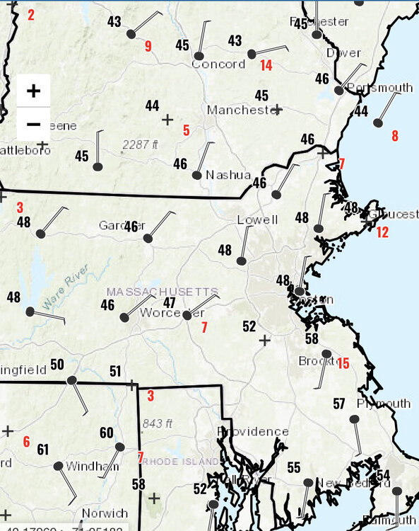
How fast is it moving? Like 1mph? It was almost to the pike around noontime…and at 6pm, BAF-ORH-BOS all socked in with northerly wind flags. -
March 2022 Obs/Disc: In Like a Lamb, Out Like a Butterfly
ORH_wxman replied to 40/70 Benchmark's topic in New England
-
March 2022 Obs/Disc: In Like a Lamb, Out Like a Butterfly
ORH_wxman replied to 40/70 Benchmark's topic in New England
The clouds and precip are the big killers in spring. If it’s sunny, you can usually get away with a nice day unless it’s one of those strong CAA airmasses with lots of wind…then it sucks.