

ORH_wxman
-
Posts
90,902 -
Joined
-
Last visited
Content Type
Profiles
Blogs
Forums
American Weather
Media Demo
Store
Gallery
Everything posted by ORH_wxman
-
There’s usually better baroclinicity in the winter too which helps intensify secondary mid-level centers which thwarts the SE flow and starts turning it more E and ENE. We don’t have that here.
-
Hopefully it keeps trending colder. It’s already doomed to be a dogshit day Tuesday. Might as well get some snow out of it. My guess is it ends up as mostly a frigid rain though.
-
That departing shortwave ahead of Tuesday’s system needs to slow down to give a good chance of snow over interior. It lifts out a little too fast which allows the Tuesday system to tuck in too tight and bring the low level flow out of the east and southeast.
-
At least we had yesterday
-
There aren't many birds that color around here that are also small, so I'd be surprised if it was something else. But yeah, Ginxy cell phone pixels FTL....too much white to be a black and white warbler. I guess it could be a lightly-colored mockingbird, but body type doesn't quite match.
-
Scooter gets revenge finally.
-
Looks like a snow bunting that hasn't migrated back north yet.
-
We don't have any Norway maples in this neighborhood, so my area always looks like a nuclear crater until at least the 3rd week of April, and often later. We have forsythia budding out and some of those thorny bushes starting to green, but basically no trees.
-
Was nice late morning but since then we’ve had a lot of clouds and wind has picked up. Temp has fallen about 4F off its high too. Back into the upper 40s.
-
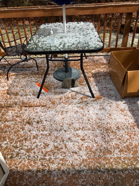
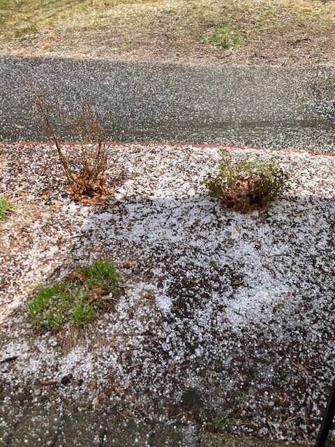
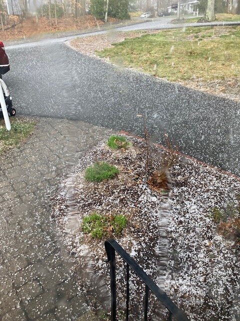
That wraps up severe season here…we won’t top that one the rest of the season. Hail was really impressive for a few min.
-
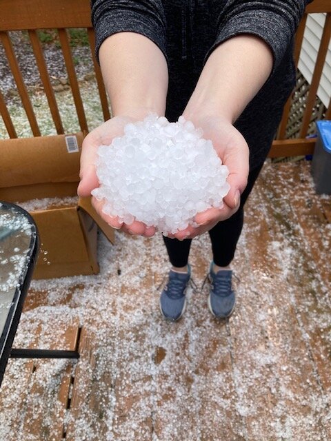
Just got smoked with hail
-
Yeah we’re due for some good Decembers. We’ve paid back our surplus from the 2000s at this point. It’s kind of like how we had a pretty long stretch of lousy Marches until 2013 broke it and then we had a bunch of good ones. I’m feeling a december turn-around at some point here soon. The funny part though is on paper, the interior had great snow Decembers in 2019 and 2020 but the cutters rendered them pretty mediocre for sensible wx. 2019 did keep pack most of the month but it had the same feel as this winter where it was often thin and icy because it was leftovers from a cutter. Last really wintry December here was 2017.
-
That's too bad...it was a pristine coop....those are getting rarer and rarer these days.
-
40" is really hard to do....a few spots got it in 1995-1996....not sure anyone did in 2004-2005, maybe briefly down near PYM but even there probably not. 2014-2015 is really the only season that did it in the coastal plain in a widespread fashion. ORH hills are a different animal...you aren't going to compete with their longer term snow depths if you are on the CP.
-
Yeah, I mean he's not in Pinkham Notch, but that area has a much higher return rate on 100" winters than where you are or down in Ginxyland. Obviously the last few seasons haven't been good there, but it doesn't really change those stats. Nobody has been really cleaning up recently. Even last winter (2020-2021), the zone that was above average was not threatening any major milestones. You had like an area of 70"+ from where I am to ORH and some 60"+ totals into N CT and N RI. It wasn't a blockbuster.
-
Your area had like 125" in '95-'96....I doubt Scooter beat you that winter. The only one for sure is 2014-2015. What about 2000-2001, 1992-1993, 1976-1977, or 1968-1969? Those were all huge winters up there that crushed the totals on the coast and S of pike.
-
Your ceiling is higher up there than south of the pike. From a raw percent anomaly standpoint it probably isn't, but from an absolute snowfall total it is. You can get 100" a lot easier than a place like N Foster for example (I purposefully picked a pretty good S of Pike station).
-
Lot of uncertainy later next week....seems like Tuesday is probably going to be pretty nice, but no guarantees after that. Some guidance punches us into a warm sector for an early summer preview but others show legit hideous high to our northeast screwing us over.
-
Yeah it was really bad there.
-
Yeah the GFS was utterly brutal..... Euro is trying to sneak at least 1 early summer day in there next Wednesday, but then I don't like the look by 216h....you have the big low out in the lakes and lurking CAD setting up in Maine and NH. Verbatim it still busts us into the 70s next Thursday, but it's 48F in PSM/Cape Ann while its 75F in ORH....more often than not that gradient ends up 100 miles southwest.
-
And there's the CAD showing up next week....hopefully we can sneak in a 70 burger before it hits us
-
Euro would prob be upper 70s to maybe low 80s if that verified. I’m bracing for the two by four to the back of the head though…waiting for that BDF to show up. But it would be a welcome several days if it doesn’t. I remember mid April 2002 very well…think we busted out like 3 or 4 consecutive 85-90F days. It was a true taste of summer. April 2009 did as well though maybe a day shorter in duration.
-
Looks like the accumulating snow level was about 1500-1600 feet. The very top of "little wachusett" in the foreground looks slightly whitened and I think thats about 1500 feet at the top of that one.
-
Yeah that storm was good. I got a bit over 8” and it was dense typical SWFE type snow that was hard to melt even with the late Feb/early March sun angle. You can see why when we get a couple of those types of systems back to back earlier in a winter (like Dec or Jan with low sun angle), it sets the stage for a good pack winter. That stuff is just really tough to melt. Totally different than the blower fluff on 1/7.
-
If the person weights cold and pack retention heavily, then they could. But for most people who post on here, I’d agree since most people here value large storms disproportionately.


