ORH_wxman
-
Posts
90,902 -
Joined
-
Last visited
Content Type
Profiles
Blogs
Forums
American Weather
Media Demo
Store
Gallery
Everything posted by ORH_wxman
-
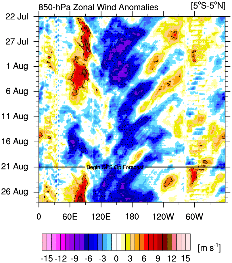
Yes. Only thing that might prevent the really cold stuff from surfacing is that so far the easterlies are having a hard time getting east of 150W or so. But even getting the good easterlies to 150W, that is far enough to cause some good upwelling into Nino 3/3.4 anyway.
-
Update: On 8/21, NSIDC SIA was 3.93 million sq. Here's how other post-2007 years compared on the same date: 2021: -300k 2020: -1.09 million (-1090k) 2019: -870k 2018: -300k 2017: -540k 2016: -820k 2015: -380k 2014: +320k 2013: -30k 2012: -1.18 million (-1180k) 2011: -780k 2010: -100k 2009: +190k 2008: -270k 2007: -900k
-
Yeah that is correct....but those subsurface anomalies are no slouch. They are very cold so I'd expect Nino 3 and 3.4 to really cool over the next month or so barring a reversal in guidance on the easterlies.
-
The only issue I have with the ECMWF forecast is it doesn't look like it's matching empirical reality early on. The Nina is def not going to steadily weaken in the next few weeks. I'd bet on strengthening looking at these graphs

-
You basically had the equivalent of widespread F2 tornado damage between BOS and CT river. That’s catastrophic.
-
If another ‘38 hit, we’d prob be out for a month outside of the densely populated areas right near cities. They’d prob get most of those back within a week or two but far suburbs/exurbs and beyond would take quite a bit longer. The sheer volume of tree damage to clear away would be the biggest limiting factor to restoring the grid.
-
Yeah though my gut says it’s not gonna be weak. We will have a better idea after the winter on how well that warm pool has maintained. But who knows. 1976-77 was a weak Nino and that was coming off a 3 year Niña.
-
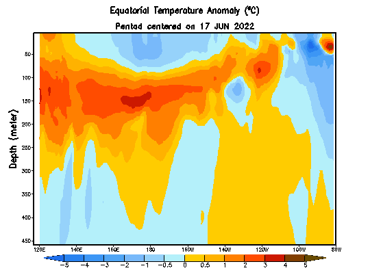
That's a good look though at least....we want the western region to warm while eastern region cools. That warm pool out west in the subsurface is probably the fuel for El Nino in 2023-2024....
-
Last two 3rd year Ninas weren't that bad....2000-2001 (which was historic further north in the interior, but still good where you are) and '75-'76 (maybe near avg there, but pretty good further northeast).
-
I did take more time off this summer than usual though....I usually still consistently post in summer, but just a more infrequent rate. I basically went 2 months without posting at all, but it was good for me since work was getting a bit much during late spring/early summer and then we had a busy family vacation schedule mid-summer. There really was nothing to post about either wx-wise most of this summer. I made some posts in the arctic sea ice thread occasionally but not in here. With ENSO starting to become more defined, I started posting in the winter thread earlier this week. But yeah, there was a time back on eastern when many of us would disappear almost the whole warm season.
-
Rubber band snaps and we get a ton of storms in fall and winter.
-
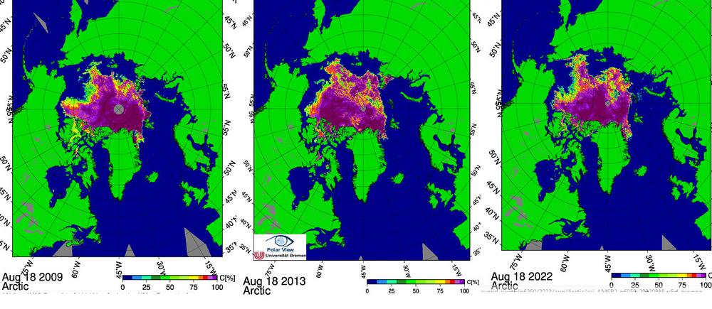
I decided to compare the other 2 closest years to this one to see if we can try and gauge how close we will finish. 2009 and 2013 are both within 10k of 2022 for sea ice area. At first glance to me, I think 2022 has more vulnerable ice than both of those years. 2022 has a more pronounced "arm" of ice into the ESS than those years had and that arm is usually vulnerable to additional melt into September if other years are any gauge. The one offsetting factor might be lower concentration ice really high in latitude near the pole....this will refreeze into 100% concentration ice very quickly in September even as the "ESS arm" continues to melt. So this would help offset the East Siberian losses at least partially. 2009 min was 3.55 million sq km and 2013 min was 3.61 million sq km. My guess is 2022 finishes below both of these, but I think it's very likely we'll finish higher than 2018 which was the 4th highest finish (3.23 million sq km) since 2007 only behind 2009, 2013, and 2014.....btw the latter year, 2014, had a big falloff from it's current position to finish in between 2009 and 2013 at a min of 3.58 million sq km.
-
Update: On 8/18, NSIDC SIA was at 3.97 million sq km. Here's how other post-2007 years compared on the same date: 2021: -280k 2020: -1.00 million (-1000k) 2019: -920k 2018: -170k 2017: -530k 2016: -770k 2015: -590k 2014: +520k 2013: -10k 2012: -1.12 million (-1120k) 2011: -660k 2010: -240k 2009: +10k 2008: -270k 2007: -870k
-
That season was historically awful after about mid-December. We had a couple of smaller events after the big one was wiped out by a cutter a week later, but then that season basically went '88-'89 on us despite being a borderline weak Nino.... If all you knew is we had a borderline weak El Nino and in early December, we had a monster storm, we'd probably be all thinking triple digit seasonal totals for the interior. Shows how much we would have known.
-
Last one around here was December 1-3, 2019. Prob have to go back to the Jan 2016 blizzard to have one for the Mid-Atlantic to NYC crowd. You need a good downstream block in the Atlantic usually and a relaxed enough flow to create a cutoff at least temporarily.
-
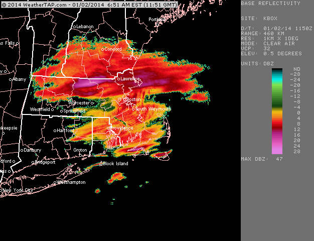
A lot of it fell before the main synoptic stuff arrived. I was actually working in Boston that day and we had a lot of weenie flakes with occasionally light-steady snow, but the radar was totally lit up on the north shore....I think some areas had 10" before the better synoptic stuff even moved in. I don't have a lot of radar saved from that storm, but here was the ocean enhancement just starting that morning. It really cranked in the several hours after this though....but you can see it starting to get going off the ocean on the north shore.
-
'13-14 really wasnt much to write home about anywhere in New England outside of maybe western CT? They did pretty far above climo I think. Feb/Mar 2014 were pretty epic in NNE and even parts of the interior of SNE but January was kind of a buzzkill despite the cold....we had like 3 separate hideous cutters that month to ruin the vibe. In NNE, January was actually just an epic turd....at least in SNE we got a couple good events despite the cutters mixed in....up there, they either whiffed or got cutters that month....very different from 1994 when at least we were keeping the cold and snowpack around when it wasn't snowing. I'd certainly take another '13-14 though....it was a solid winter, but it falls short of several others in the past 15 years like '17-18, '14-15, '12-13, and '10-11.
-
Yeah and we actually got some ridiculous stuff in the 2013-2015 period further east. Some stations in the Midwest/upper plains had their coldest winter on record in 2013-2014. Then a chunk of New England had their coldest month on record in February 2015.
-
Yeah the plains and Canada haven’t had any trouble being cold recently. We’re getting shafted recently on top of any underlying warming trend. I’ll have to find the graphic (or I could prob just make one I guess), but I recently saw a NHEM temp trend from 1990-2021 and New England was one of the warmest trends anywhere outside of the arctic. We can send that one to Tip when he says we’ve been avoiding the warming….maybe for a while we were but not anymore.
-
One that actually acts like it too. (Unlike the faux ‘18-19 version)
-
It really seems like the best combo for widespread cold is a -PDO regime in the N PAC combined with ENSO skewing warm. It’s kind of a weird combo since -PDO tends to go with Nina but that 2009-2015 period had a couple El Niño events and a warm neutral mixed in there despite the -PDO dominating….at least until 2014 when it started shifting positive before ‘14-15 winter. Now the -PDO has been dominating again but we can’t buy an El Niño except for that fraud 2018-2019 event which acted like a La Niña anyway. This winter will be the 5th La Niña since 2016.
-
Even the river valley there is around 850-900 so most places are high, but the relative elevation matters a lot once you get on the west side of the slopes there. The eastern side of Templeton closer to Gardner airport would def do better than the western lower part near Phillipston but even the “screw zone” in Templeton isn’t going to be under a 70” average I don’t think. Maybe high 60s at worst. The 1200-1300 foot zone near Gardner prob gets 75-80”.
-
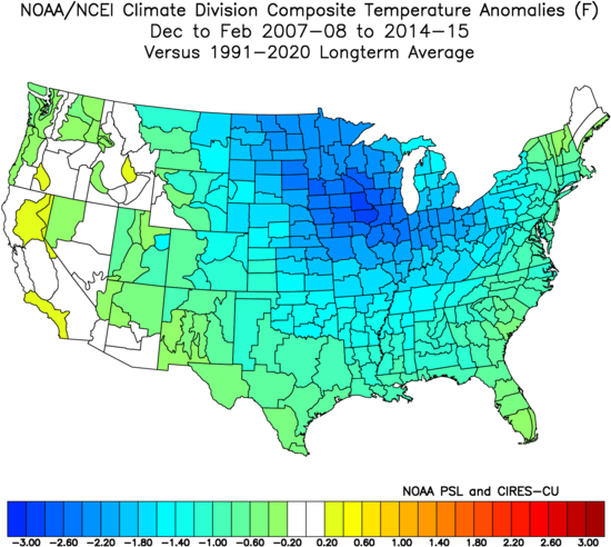
Or we could just get a lot of cold everywhere like ‘07-08 to ‘14-15
-
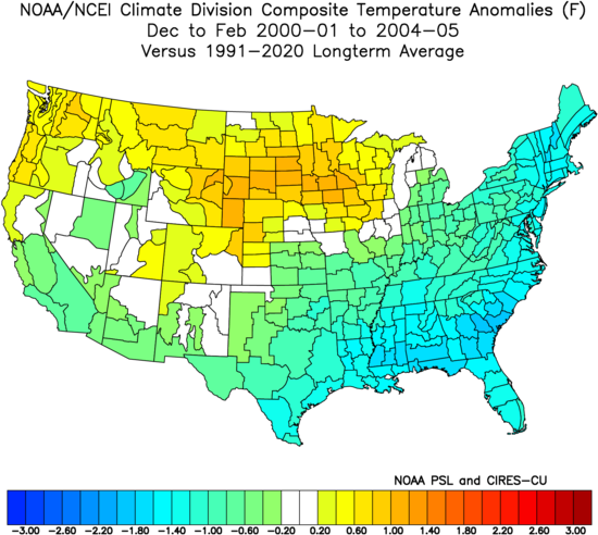
Going back to the temp anomalies. We probably need some weak ENSO events that skew toward El Niño to shift the temps more toward cold in the east relative to the plains. Kind of like the 5 year period we saw between 2000-2001 and 2004-2005
-
Yeah it depends on where he is. If he’s down near the Burnshirt River on the western side then it will be notably less than Hubbdave but the Eastern and southeastern side of Templeton is really high. Like 1100-1300 feet. They might get even a little more.