

ORH_wxman
-
Posts
90,902 -
Joined
-
Last visited
Content Type
Profiles
Blogs
Forums
American Weather
Media Demo
Store
Gallery
Everything posted by ORH_wxman
-
Update: NSIDC SIA was 3.24 million sq km on 9/11.....this is 40k above the minimum of 3.20 million sq km several days ago. There is still a chance we could set a new minimum being that close, however, the lower concentration ice near the pole is starting to rapidly freeze and there have been some slight gains in the Beaufort over the weekend, so this will make it hard to dip much more....the losses in the still-vulnerable ESS will have to be higher than the gains elsewhere. NSIDC extent currently sits at 4.82 million sq km. This is slightly above the min (so far) of 4.80 million sq km. This has a better chance than area to dip back below the min, but no guarantees on that either.
-
I mean it almost happened again in 2008. It was just a more marginal airmass in ‘73. You have to walk a fine line between too much cold (which causes more sleet/snow) and not enough like ‘08 south of ORH. Usually a pretty epic setup happens once per decade or 15 years and then you have to see if you cash in. We really haven’t had a great setup in a while so we’re kind of due. 12/23/17 was close but not quite.
-
Yeah that one was very widespread too. Got into BOS and PVD. Tolland prob came close in Nov 2002 as well but the real high-end stuff was more in NW CT. I think Tolland prob had more like a third to a half inch of accretion in that one. There was another in early January 2005 that dropped similar amounts to the 2002 event in N CT at elevation…we actually had mostly/all snow in ORH in that one with like 8-10”.
-
Yeah typically you want to see about 500m of below freezing to start refreezing into ice pellets, but there are caveats which often apply to New England ice events…hence the frequent ice events where the layer is more like 800-1000m thick….if the warm layer is greater than 6C, then you will not refreeze into ice pellets. This happens a lot in our siggy icing events…we’ll be blasting +8 to +10C at 850 while we wedge a cold layer of -5 or -6C at 925 underneath it (translating to -2 or -3 at the sfc…or -1C in the case of 2008, lol) On the flip side, if you have a warm layer that is merely +1 or +2C, you will have a hard time getting straight ZR and usually that’s a scalp-fest.
-
That is mostly correct for down here too....the rare in-situ icing event with light SE winds or something is when you'll actually see the CT River valley hang on the longest. Usually these events aren't huge though because they only last a few hours and below freezing layer is very thin so accretion is not very efficient. If we're talking situations where an ice storm warning may be necessary, it's almost always going to be worse with elevation (at least up to a point like you said...usually around 2k feet or so)
-
I remember at 1200 feet in Paxton had at least half an inch of ice one of the days when the cold drain came pretty far south. I think the whole town lost power for a while….similar in Holden. We had a light glaze in ORH at 600 feet where I was at the time…but even up on the hills above 800 feet you could see significantly more.
-
Saw this in the Dec '08 ice storm....FIT and Leominster at 300-400 feet were covered in over an inch of ice and looked like a war zone....you went up to the other side and even areas at like 800-900 feet near ORE and Athol had trouble accreting more than a tenth or two.
-
I started figuring it out in the early '90s when we had some ice events and on the weather channel local forecatss when they showed the nearby obs, Chicopee Falls and Hartford and Windsor Locks were always like 34F and raining. I kept thinking "I remember reading that valleys are supposed to keep the ice longer, why are they always warmer in these events?" Then I remember Harvey cam eon in an event maybe in the mid'90s and explained that the coldest layer of the atmosphere was actually around 1500-2000 feet in an ice event, and that is when it started really clicking....the soundings later on just confirmed when I had started learning.
-
There really isn't a replacement for looking at models all the time and noticing what they do in winter storms. Basically experience. That requires a lot of weenie-ism though as you said. You have to want to look at them all the time or you never will. You can read stuff from a textbook, but it is not always going to help....or you might even get the wrong idea if it's not applicable to our area. I know Chris (Oceanstatewx) and I have discussed in the past on here how reading about ice storm climo/setups in a text book will probably get you into a lot of trouble in New England because a lot of that climo and literature was based off the midwest/plains where the undercutting airmasses are typically shallower....so they all say "the ice will be the worst in the valleys and hold there the longest".....whereas in New England, we typically have a normal lapse rate in the lowest 2000-2500 feet so elevation actually helps in most cases up to that level while a lot of times the valleys could be raining. If you didn't look at obs all the time, soundings all the time, or drive around like a weenie during marginal ice events, you might never really learn about our icing climo and still think the cookie cutter textbook is the way to forecast here.
-
Given how uncertain LR forecasting is, the math becomes less and less useful and learning to analyze, quality-check, and weight data becomes a lot more important. There is definitely a bit of art to LR forecasting. The physics/math seems to become more important in shorter term forecasts where we have a lot more certainty on certain parameters....like, I can say "jesus, there is a 75 knot low-level jet slamming into a dead calm cold dome over the interior.....I don't care what certain QPF forecasts look like, someone is going to get a fronto death band". But even these days, the models have gotten so much better, you don't have to augment them as much as we did 15 years ago. Back in the late-aughts, we still had model guidance that would print a half inch of QPF in the cold sector of a coastal when you had dynamics that would easily support double that and we had to tell everyone to stop being QPF queens. Nowadays, the discrepancies aren't as large, though they obviously still do exist.
-
It's going to be hard to run a correlation on temps alone that mean much.....mostly because the Antarctic SPV was affected by the ozone hole for so long which cooled the stratosphere down there. So you are prob going to get an inverse correlation for the rest of the globe.....which can be explained by that. If we could somehow remove that influence, it would be helpful.
-
Yeah that was an ugly Ukie run...+EPO/NAO pattern....woof. Prob something like '98-99 or '99-'00.
-
What model ensemble is that? That NAO looks pretty ridiculous.
-
Update: On 9/6, NSIDC SIA fell to 3.2 million sq km...this puts 2022 slightly below 2018's 3.23 million sq km minimum. The low concentration ice near the pole has yet to refreeze which allowed the losses on the periphery to add up enough to pass 2018. The next one on the list is 2021 which had a min of 3.16 million sq km. As for extent, the NSIDC extent is currently at 4.85 million sq km. We'll see how much lower this goes in the next few days...we haven't had a min above 4.8 million sq km since 2014 (though last year was close at 4.72 million sq km). My guess is we drop below 4.8 million sq km and perhaps below last year as well, but no guarantees.
-
Yes agreed....that would be frigid in Canada with that H5 pattern....and hopefully we'd get some better timing to allow for more SWFEs and keeping the cold locked into New England over the top. Hopefully we see that Aleutian ridge beef up a little more on future runs which would help push the cold a little further south.
-
No it was mostly rain into the Berkshires too except a bit of snow at the onset. I think the high terrain of VT/NH got at least some paste in that one. You might be thinking of the 2/24/10 storm. That one crushed ORH county back to the Berkshires. MPM had like 2 feet. I had about a foot in ORH before it mixed while 495 eastward had zilch. Then the retro-rainstorm the next day ruined a lot of it but it changed back to snow pretty quickly in the Berkshires and they picked up another 10-15”. I think even Hubbdave got another 8-10” too and I couldn’t believe it since I wasn’t that far from him but only got 2-3” after it flipped back.
-
I always say that was the week a toddler-aged Bryce learned all the swear words.
-
I think my one melt in the middle of an event was the firehose rain storm in mid-March 2010. We missed a 2-3 foot paste bomb by like 1C over the interior. (We actually had a little wet snow at the beginning) Everyone has at least one. Some have hundreds, lol.
-
Might be one last hurrah…not sure if it will be enough for 3 tenths but it has a chance if you can get under one of the heavier echoes and they don’t weaken.
-
You had a mini melt before 3/4/19. You were all “congrats powderfreak. Congrats dendrite” every run that wiggled north. Then we made fun of you for b**ching your way to 17-18 inches, lol.
-
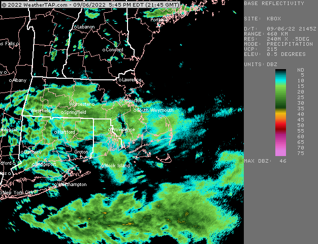
About 3.60” right now. Over an inch in the past 3 hours. Just steady heavy rain but nothing torrential.
-
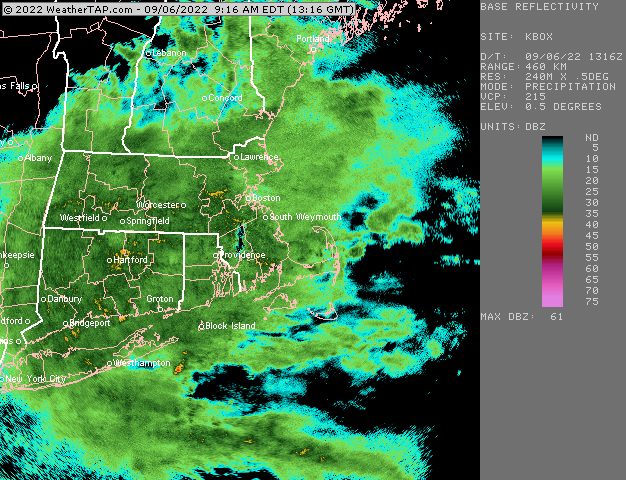
That’s just the beam being blocked by something close by to the tower.
-
Looks like wxwatcher91 finally got some good rates in HFD too…a nice region-wide soaker
-
Triggered.
-
If that was the radar in a 25F airmass in December you’d be floating face down in your local salt marsh.


