ORH_wxman
-
Posts
90,902 -
Joined
-
Last visited
Content Type
Profiles
Blogs
Forums
American Weather
Media Demo
Store
Gallery
Everything posted by ORH_wxman
-
I think it’s a fluke. Dec ‘92 didn’t screw N RI like Mar ‘13 did. Woonsocket over to Burrilville got annihilated.
-
You’d do well on a more easterly flow like a Dec ‘92. Regular coastal with winds more NNE don’t provide enhancement there….the rare westerly flow event does well there too.
-
Yeah some of those scrapers can give PTSD in the interior. But in my long experience with central MA wx, I feel like as long as you are on the east slope of the ORH hills, higher elevation is going to equal more ice and more snow. The extra elevation outstrips any other variable when you are still on the east side of the spine. Once you go west of the spine far enough, things change since you start to lose the orographic enhancement on easterly and northeasterly flow.
-
My guess is you get both a little more ice and a little more snow there.
-
No he must be up by Justice hill in Sterling...i don't think anywhere else is in town is high enough to be over 800 feet.
-
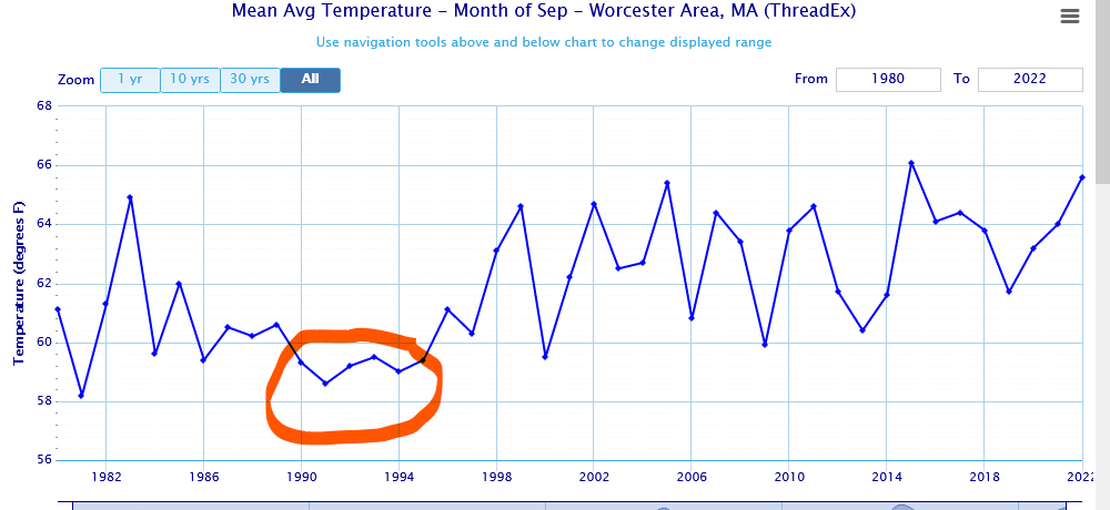
We had some cold Septembers back then....they show up well on the time series:
-
Took ORH until noontime to reach 60F under full sun. Pretty decent airmass for mid-September....esp compared to the most recent 10 or 15 years (Sept has been one of the warmest months relative to avg)
-
Update: NSIDC area stood at 3.28 million sq km on 9/15. There is a good chance we've reached the minimum already, but we're still close enough (80k higher than min) that we can't call it quite yet. NSIDC extent continues to fall though, down to 4.65 million sq km. So we likely haven't reached the min yet on extent. I'll do a full verification of earlier prediction on 7/1 once both area nd extent min have been reached.
-
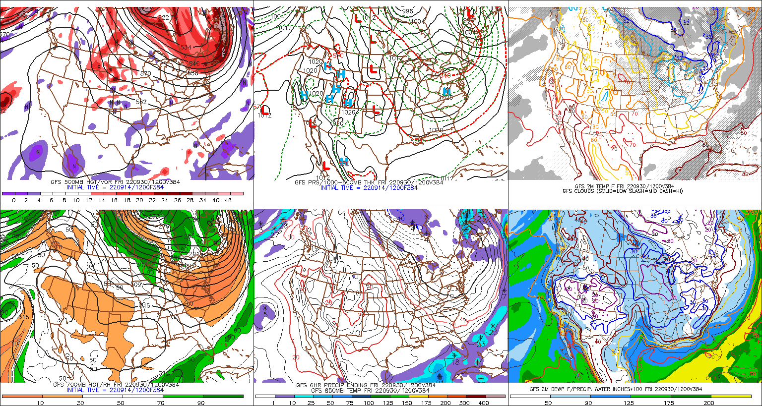
Shortwave behind that tracks into Quebec....need it further south for a good SWFE.
-
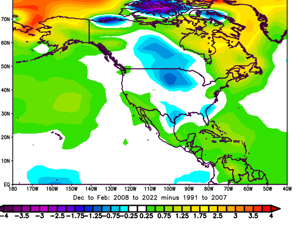
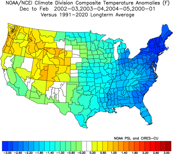
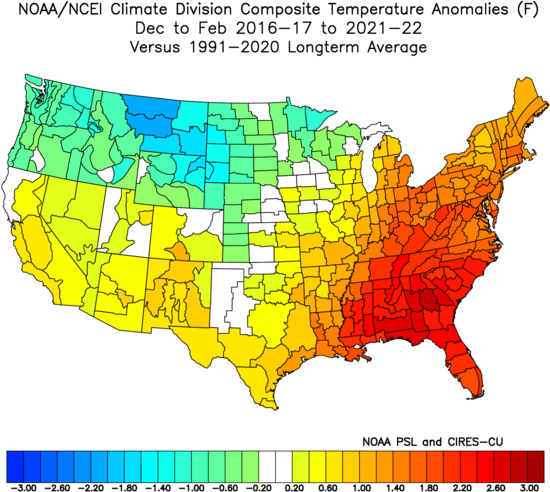
To further my point above....this is pretty amazing....look at the difference in winter temps between 2008-2022 and 1991-2007.....where is the warmest region in the US? New England. Coldest? Upper plains. A winter like '02-'03 would def work to reverse that trend. That winter was actually pretty mild in the northern plains but it was frigid over NE.
-
You could maybe throw in December 2017 into early January 2018 for another semi-sustained period where the cold was centered over us. But yeah, it's been pretty tough on a longer timeline since those early 2000s winters.....most of the cold has been centered over the plain states and into upper Rockies.....theyve had colder winters in the past 10-15 years there than they did in the 1990-2005 period.
-
Yeah those colder early 2000s winters (sans '01-'02) had the cold centered right over NY/New England. We haven't really seen that since on any sustained basis except maybe for that 8-10 week period in 2015.
-
Not sure there is anything more insecure than going on a weather forum and chastising people and then bragging about your wealth.....you hate to see it.
-
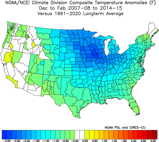
I would argue we weren't the center of the cold either in the 2007-2015 period.....we did have the record-breaking cold in Feb 2015, but the cold anomalies were largely centered to our west otherwise
-
Prior to 2015 maybe that was the case, but not since then....the eastern US has been a torch....only the far southeast US has been warmer than our region.
-
The northeast has actually been one of the warmest regions relative to average in the entire country since the 2015 snow/cold blitz. So a little regression on that front wouldn’t be surprising.
-
Maybe we can have a repeat of 9/30/92....only 60 runs to go
-
We're definitely overdue for a big -NAO December....haven't had one since the back to back jobs in 2009 and 2010.
-
We didn’t have a very poleward Aleutian ridge either last December. We still could’ve done well with a slightly less ridiculous PNA trough out west, but a much better EPO region would’ve made things a lot easier. You push the meat grinder region further southeast in that scenario….and we end up a lot colder with a little more space to maintain shortwaves.
-
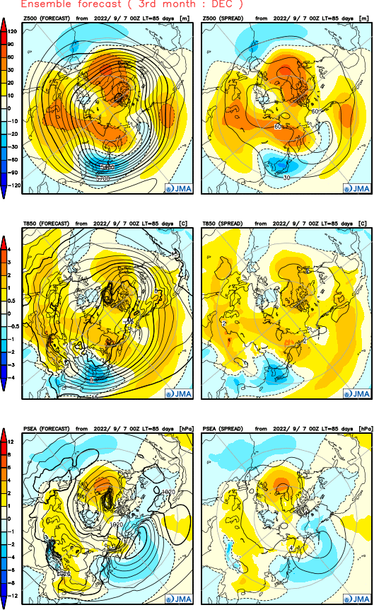
JMA wants to slam the big -NAO in December....we've seen this from a few seasonals. I'm skeptical of seasonal models but if there's a theme that starts emerging, I want to see if it actually verifies.
-
I'm not sure it affects us that drastically once winter comes around. The entire arctic ocean save for maybe near the Bering Strait is long frozen by that point.....but fast refreeze could lead to colder airmasses earlier in fall. There's some research that all the latent heat release from fast refreeze could affect the height pattern up there in different ways, but it's still pretty marginal attribution at the moment.
-
Here's one list....but it only goes through 2013. Looks like there's plenty of events that happened in a westerly QBO phase. Easterly is favored for sure, but it's like a 60/40 split. This list was only "major" events which actually reverse the wind field. https://www.researchgate.net/figure/List-of-the-Major-SSW-Events-Recorded-Between-1958-and-2013-Peak-lunar-tidal-Peak-ZMZW_tbl1_324608809
-
Yeah although there was a pretty good one in late Feb 1995 and early March 1991. But the really high-end ones seem to be earlier in the winter.
-
Widespread damaging ice storms are pretty rare whereas the localized ones are more common for obvious reasons. An often-overlooked biggie was Dec 3-5, 1964....that was prob the benchmark for post-1950 ice storms in interior SNE until December 2008 happened. The December 1964 ice storm was particularly damaging across eastern NY State too. I think Albany had almost an inch of ice in that. But pretty much everyone from about I-495 up around Ray's area down to my area and out to E NY got absolutely crushed. The ice even got into BOS in the latter half of the system and produced significant accretion but it was nothing like it was over the interior. One of the unique things about the December 2008 ice storm was that unlike most of the other monsters on the list, it was fairly short-lived. It happened mostly over a 12-18 hour period. Most places had only minor accretion during the day on 12/11....and then all hell broke loose overnight and it was done by 7-8am the next morning.
-
Mostly confined to Litchfield county...so I don't think it can be considered in the same league as a storm like 1921. It was pretty devastating where it stayed ice though....just not a huge area like some other storms.