

ORH_wxman
-
Posts
90,902 -
Joined
-
Last visited
Content Type
Profiles
Blogs
Forums
American Weather
Media Demo
Store
Gallery
Everything posted by ORH_wxman
-
Me too. I remember every tropical update that summer. Hurricane Allison and Hurricane Erin were two of my favorites and then it felt like we were tracking Felix for an eternity as it teased the east coast a couple times before recurving. Hell I even remember some of he useless pacific hurricanes that formed off western Mexico and went to nowhere. Then you had threats way into October with Hurricane Opal…and by the time you were done with that, the snows started two weeks later in early November and we weren’t taking a Gatorade break until late April. It was like being a little kid in ToysRUS where your attention span never had a chance to suffer boredom. If the booms and busts of the late 80s/early 90s cemented me as a wx weenie, June 1995-April 1996 made me downright obsessed with weather.
-
Sounds like attendance at this one is going to be pretty good.
-
A lot of seasonal models have liked November to be pretty cold too....my hope is that it is skewed toward 2nd half of November and carries over into December.
-
Your 'hood is due for a good one....been kind of rough on the north shore of MA and sea coast of NH the last few winters.
-
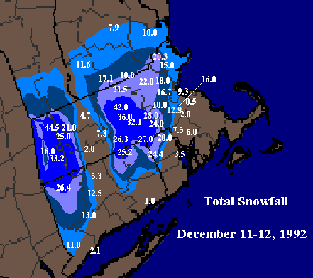
The Franklin coop to the west of Walpole at 250-300 feet reported 28 inches....which I think is not totally believable, but you get the idea on the gradient. I could believe the higher spots in Walpole getting 18" though. The 12.9" from the coop was one of the lower spots at 170 feet. Those spots in Walpole at 250-350 feet prob did quite a bit better.
-
Still a few showers west near ME/NH border, but mostly done.
-
From my memory, you are correct about the forecasts leading into Friday and including Friday morning itself. What I recall happening though is an "over correction" by late Friday night where they assumed the R/S line would just keep collapsing SE to include the south shore and much of SE MA so they hoisted blizzard warnings right to places like PYM, but it actually stalled before getting there.
-
I think this reflects the totals a bit better....added the 20.3" up near Ray at Groveland coop and brought 20" contour a bit southeast into far western Norfolk county near Medway/Bellingham/Franklin. I added Walpole's 12.9" total too in there on the plot and Hopkinton's 28".
-
There was a huge directional gradient right around there (in addition to elevation which was obvious in that storm). I think Walpole had 13", then once you got up to around Hopkinton/Milford, it was 24-28", and then back southeast to near Attleboro as you said, it was single digits. I need to tighten up the gradient between Milford and Mansfield....the 20"+ was actually a bit southeast of where I have it on that map but then it goes from that to single digits really fast so I should make the map reflect that a bit better.
-
I actually have to extend that 20" contour further northeast to near Ray's current location (Groveland coop had over 20" from that event). I noticed it a few years ago but never updated it. Also have to extend it SE past my current area. The really tight gradient is near Walpole/Franklin.
-
Almost Halloween....time to give Scooter nightmares.

-
"I can't believe I got 12"!!!" (when every single model had an inch of QPF all snow with the dynamics to support it)
-
Both the reverse psychology and the over-zealous positive hype are manifestations of emotion over science and objectivity. They both degrade the integrity of the discussion from a scientific standpoint. Everyone is susceptible to it, but controlling it as much as possible will lead to more accurate forecasts and better dialogue.
-
Hype sells, but reverse psychology is also rampant on here. Just downplay and poo-poo every event so you can convince yourself that you are not "invested emotionally" in a winter or a storm threat.
-
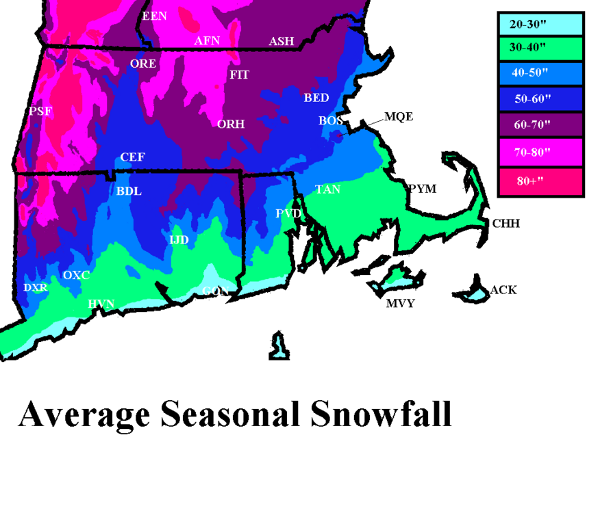
Foxborough itself is actually not bad for snow....gets more than Boston does being southwest inland and a few hundred feet in elevation. If you want, say, another 10-15" per year and a bit better retention, then you'll want to move northwest of Foxborough out toward ORH...but as someone already said, that's a bit of a haul. IF you don't mind an hour commute though, then it works. Best spot near ORH is probably on west side in the town of Paxton or some of the high spots in Holden. My current area (Holliston/Hopkinton/Ashland) is a bit closer and maybe 30 minutes away but probably gets 10" more than Foxborough with better retention. Hopkinton esp is good because it has a lot of spots over 500 feet in elevation. Here's my crude SNE annual snowfall map i made years ago. Foxborough is basically halfway between BOS and PVD in that band of 50"+ that extends southeast from the main dark blue area.
-
What did you get there? About 30 inches in that storm? There were other storms that month too which were good over the interior.
-
Yes it was still a good event inland but we spent most of that storm watching messenger post about heavy bands down in that area. Ray made a comment about the storm being a little lame compared to a few of the meso model runs early that morning and messenger posts about how good it is down there and then Ray just goes off about cranberry bogs and nobody giving a crap about the 5 people who live there…LOL. Just classic.
-
That’s when Ray went on his infamous Cranberry Bog rant….one of the all-timers. LOL.

-
Yep obviously. Lol. Still had a good pack on Xmas after the cutter on Xmas Eve but man, we were so close to currier and Ives perfection that year.
-
It was almost 3-pronged….you had the classic SWFE (all snow version) portion on 12/19…everyone gets 6-10” from that. Then on 12/20, we had the CJ/IVT hanging back with those frigid temps. Some places on the coast picked up an extra 6-7” of fluff. Even back in ORH, I had 3” from that. Then on 12/21 we had the late blooming redeveloper….that’s where you jackpotted for SNE playing naked twister with the CF(and really close to coast flipped to rain) and you also getting a piece of the late-blooming deformation zone later that evening to give you an extra 3-4”. I remember you had like 12-13” in that 12/21 portion while I had around 8-9” in ORH.
-
Ha I remember that happening in the 12/19-20, 2007 OES/IVT event. He had like an inch and then started dripping at 34F when the sun came out while it snowed for another 8-12 hours out east with temps in the 20s.
-
Yeah basically inside of 128 got screwed with BL temps. But even out in ORH where we stayed all snow, we got dryslotted horribly after 10 inches. It was a good storm but nothing amazing…and seeing the deformation band out in E NY down to NNJ made it less appealing too.
-
How about one of those really cold early season events to track where there’s ocean enhancement and light easterly flow. Like 12/19-20/08 or something like that.
-
I think he was saying “horrible” in that he didn’t want to experience that winter again down where he is. Despite the March ‘01 debacle down there, it actually wasn’t a bad winter for NYC. They got the big 12/30/00 storm, though 2/5/01 there was excruciating (big snow just to the west) and of course the March bust.
-
It depends if he ends up in the doghouse with his better half if there’s a big snow event in the first week of December.


